
Red Bluff, California facts for kids
Quick facts for kids
City of Red Bluff
|
|
|---|---|

Cone & Kimball Plaza clocktower, known as the "Center of the City"
|
|
| Motto(s):
"A Great Place To Live"
|
|

Location in California (left) and Tehama County (right)
|
|

Red Bluff, California
Location in the United States

Red Bluff, California
Location in California
|
|
| Country | United States |
| State | California |
| County | Tehama |
| Incorporated | March 31, 1876 |
| Area | |
| • City | 7.67 sq mi (19.88 km2) |
| • Land | 7.56 sq mi (19.58 km2) |
| • Water | 0.11 sq mi (0.30 km2) 1.48% |
| Elevation | 305 ft (93 m) |
| Population
(2020)
|
|
| • City | 14,710 |
| • Density | 1,917.9/sq mi (739.9/km2) |
| • Urban | 18,434 |
| Time zone | UTC−8 (Pacific (PST)) |
| • Summer (DST) | UTC−7 (PDT) |
| ZIP code |
96080
|
| Area code | 530 |
| FIPS code | 06-59892 |
| GNIS feature IDs | 277581, 2411527 |
Red Bluff is a city in and the county seat of Tehama County, California, United States. The population was 14,710 at the 2020 census, up from 14,076 at the 2010 census.
It is located 131 miles (211 kilometers) north of Sacramento, 31 miles (50 km) south of Redding, and it is bisected by Interstate 5. Red Bluff is situated on the banks of the upper Sacramento River.
It was originally known as Leodocia, but was renamed to Covertsburg in 1853. It got its current name in 1854. Located at the head of navigation on the Sacramento River the town flourished in the mid to late 19th century as a landing point for miners heading to the Trinity County gold fields and later as a temporary terminus for the Southern Pacific Railroad's northward expansion.
Contents
Geography
Red Bluff is on the northern edge of the Sacramento Valley, and is the third largest city in the Shasta Cascade region. It is about 30 mi (48 km) south of Redding, 40 mi (64 km) northwest of Chico, and 125 mi (201 km) north of Sacramento.
The city is located at 40°10′36″N 122°14′17″W / 40.17667°N 122.23806°W (40.176640, -122.237951). According to the United States Census Bureau, the city has a total area of 7.7 square miles (20 km2). 7.6 square miles (20 km2) of it is land and 0.1 square miles (0.26 km2) of it is water. The total area is 1.48% water.
History
The Nomlaki (Central Wintun) and Southern Yana people originally inhabited the area along the banks of the Sacramento River where Red Bluff was built. Most of the native population of the area are thought to have died in a malaria epidemic or smallpox epidemic brought by trappers in the early 1830s, shortly before white settlers arrived in the 1840s.
While the Spanish army officer Gabriel Moraga explored the southern Sacramento Valley in 1808, it was not until the 1821 expedition of Luís Antonio Argüello that Europeans recorded a visit to the Red Bluff area. On April 10, 1828, Jedediah Smith passed through on the way to Oregon. In 1843 Peter Lassen, John Bidwell, and John Burheim came in pursuit of horse thieves; Lassen then applied for a Mexican land grant. The first house where Red Bluff now is an adobe structure put up late in 1849 by John Myers, who conducted it for a short time as a hotel. In the following spring Mr. Cooper erected a small adobe there, and A.M. Dibble built another at the "Adobe" Ferry, one mile (1.6 km) north. This adobe has been incorrectly associated with William B. Ide, whose home was south of Red Bluff. Settlement began in 1850 when Sashel Woods and Charles L. Wilson began laying out a town called Leodocia. It was known by that name and Covertsburg until 1854, when maps showed the community as Red Bluffs.
In 1851 Captain Ellbridge G. Reed built and started a hotel near where the creek now known as Reeds Creek enters the Sacramento River and conducted it with great success for years. Being at the head of navigation, Red Bluff soon forged ahead, and during the early mining excitements in the northern mines was a great staging town, and did an immense amount of transhipping and teaming of goods. It languished later on with the subsidence of activity in the mines, reviving again in the early 1870s on the advent of the railroad. In 1854 Red Bluff had a population of 1,000 people. In 1860 it had twice as many. On the organization of the county in 1856, there was a strong attempt to locate the county seat at Tehama, but in March, 1857, Red Bluff was chosen.
The city of Red Bluff was incorporated in 1876.
Climate
Red Bluff has a Mediterranean climate (Csa) with cool, wet winters and hot, dry summers. There are an average of 100.1 days annually with highs of 90 °F (32 °C) or higher and an average of 21.5 days with lows of 32 °F (0 °C) or lower. The record highest temperature was 121 °F (49 °C) on August 7, 1981, and the record lowest temperature was 17 °F (−8 °C) on January 9, 1937. Annual precipitation averages 23.21 inches (59.0 cm) with measurable precipitation falling of an average of 71 days. The wettest year was 1983 with 52.98 inches (134.6 cm) and the driest year was 1976 with 7.20 inches (18.3 cm). The most rainfall in one month was 21.47 inches (54.5 cm) in January 1995 and the most rainfall in 24 hours was 3.55 inches (9.0 cm) on January 8, 1995. The most snowfall in one month was 15.0 inches (38 cm) in January 1937.
| Climate data for Red Bluff, California (Red Bluff Municipal Airport), 1981–2010 normals | |||||||||||||
|---|---|---|---|---|---|---|---|---|---|---|---|---|---|
| Month | Jan | Feb | Mar | Apr | May | Jun | Jul | Aug | Sep | Oct | Nov | Dec | Year |
| Record high °F (°C) | 80 (27) |
85 (29) |
92 (33) |
98 (37) |
108 (42) |
117 (47) |
119 (48) |
121 (49) |
118 (48) |
107 (42) |
93 (34) |
83 (28) |
121 (49) |
| Average high °F (°C) | 54.9 (12.7) |
60.0 (15.6) |
64.9 (18.3) |
71.2 (21.8) |
81.1 (27.3) |
90.0 (32.2) |
97.2 (36.2) |
95.7 (35.4) |
90.0 (32.2) |
78.2 (25.7) |
62.7 (17.1) |
54.3 (12.4) |
75.0 (23.9) |
| Average low °F (°C) | 37.9 (3.3) |
40.7 (4.8) |
43.6 (6.4) |
47.0 (8.3) |
54.3 (12.4) |
61.7 (16.5) |
65.6 (18.7) |
63.0 (17.2) |
58.8 (14.9) |
51.2 (10.7) |
42.3 (5.7) |
37.5 (3.1) |
50.3 (10.2) |
| Record low °F (°C) | 17 (−8) |
21 (−6) |
26 (−3) |
28 (−2) |
33 (1) |
42 (6) |
51 (11) |
50 (10) |
41 (5) |
30 (−1) |
24 (−4) |
13 (−11) |
13 (−11) |
| Average precipitation inches (mm) | 5.02 (128) |
4.06 (103) |
3.20 (81) |
1.56 (40) |
1.22 (31) |
0.47 (12) |
0.11 (2.8) |
0.13 (3.3) |
0.50 (13) |
1.21 (31) |
2.85 (72) |
4.16 (106) |
24.49 (622) |
| Average snowfall inches (cm) | 0.4 (1.0) |
0 (0) |
0 (0) |
0 (0) |
0 (0) |
0 (0) |
0 (0) |
0 (0) |
0 (0) |
0 (0) |
0 (0) |
0.7 (1.8) |
1.1 (2.8) |
| Average precipitation days (≥ 0.01 in) | 11.1 | 9.9 | 9.8 | 6.5 | 5.0 | 2.5 | 0.4 | 0.6 | 1.6 | 4.1 | 8.6 | 10.8 | 70.9 |
| Average snowy days (≥ 0.1 in) | 0.3 | 0.1 | 0 | 0 | 0 | 0 | 0 | 0 | 0 | 0 | 0 | 0.3 | 0.7 |
| Mean monthly sunshine hours | 165.1 | 195.2 | 267.8 | 328.8 | 396.3 | 404.4 | 436.9 | 397.5 | 344.0 | 281.4 | 172.1 | 153.4 | 3,542.9 |
| Source: NOAA | |||||||||||||
Demographics
| Historical population | |||
|---|---|---|---|
| Census | Pop. | %± | |
| 1870 | 992 | — | |
| 1880 | 2,106 | 112.3% | |
| 1890 | 2,608 | 23.8% | |
| 1900 | 2,750 | 5.4% | |
| 1910 | 3,530 | 28.4% | |
| 1920 | 3,104 | −12.1% | |
| 1930 | 3,517 | 13.3% | |
| 1940 | 3,824 | 8.7% | |
| 1950 | 4,905 | 28.3% | |
| 1960 | 7,202 | 46.8% | |
| 1970 | 7,676 | 6.6% | |
| 1980 | 9,490 | 23.6% | |
| 1990 | 12,363 | 30.3% | |
| 2000 | 13,147 | 6.3% | |
| 2010 | 14,076 | 7.1% | |
| 2020 | 14,710 | 4.5% | |
| U.S. Decennial Census | |||
2010
At the 2010 census Red Bluff had a population of 14,076. The population density was 1,833.6 people per square mile (708.0/km2). The racial makeup of Red Bluff was 11,366 (80.7%) White, 128 (0.9%) African American, 438 (3.1%) Native American, 187 (1.3%) Asian, 16 (0.1%) Pacific Islander, 1,168 (8.3%) from other races, and 773 (5.5%) from two or more races. Hispanic or Latino of any race were 3,037 persons (21.6%).
The census reported that 13,637 people (96.9% of the population) lived in households, 150 (1.1%) lived in non-institutionalized group quarters, and 289 (2.1%) were institutionalized.
There were 5,376 households, 2,033 (37.8%) had children under the age of 18 living in them, 1,969 (36.6%) were opposite-sex married couples living together, 1,022 (19.0%) had a female householder with no husband present, 404 (7.5%) had a male householder with no wife present. There were 537 (10.0%) unmarried opposite-sex partnerships, and 27 (0.5%) same-sex married couples or partnerships. 1,629 households (30.3%) were one person and 678 (12.6%) had someone living alone who was 65 or older. The average household size was 2.54. There were 3,395 families (63.2% of households); the average family size was 3.11.
The age distribution was 3,950 people (28.1%) under the age of 18, 1,534 people (10.9%) aged 18 to 24, 3,561 people (25.3%) aged 25 to 44, 3,157 people (22.4%) aged 45 to 64, and 1,874 people (13.3%) who were 65 or older. The median age was 32.2 years. For every 100 females, there were 92.4 males. For every 100 females age 18 and over, there were 87.7 males.
There were 5,872 housing units at an average density of 764.9 per square mile, of the occupied units 2,277 (42.4%) were owner-occupied and 3,099 (57.6%) were rented. The homeowner vacancy rate was 3.5%; the rental vacancy rate was 7.3%. 5,652 people (40.2% of the population) lived in owner-occupied housing units and 7,985 people (56.7%) lived in rental housing units.
2000
At the 2000 census there were 13,147 people in 5,109 households, including 3,239 families, in the city. The population density was 1,768.7 people per square mile (683.2/km2). There were 5,567 housing units at an average density of 748.9 per square mile (289.3/km2). The racial makeup of the city was 86.7% White, 0.6% Black, 2.2% Native American, 1.6% Asian, 0.1% Pacific Islander, 5.8% from other races, and 3.0% from two or more races. Hispanic or Latino of any race were 13.7%.
Of the 5,109 households 36.2% had children under the age of 18 living with them, 42.4% were married couples living together, 16.5% had a female householder with no husband present, and 36.6% were non-families. 30.7% of households were one person and 14.0% were one person aged 65 or older. The average household size was 2.47 and the average family size was 3.07.
The age distribution was 28.7% under the age of 18, 9.9% from 18 to 24, 28.6% from 25 to 44, 18.0% from 45 to 64, and 14.7% 65 or older. The median age was 34 years. For every 100 females, there were 90.1 males. For every 100 females age 18 and over, there were 84.1 males.
The median income for a household in the city was $27,029, and the median family income was $32,799. Males had a median income of $26,807 versus $21,048 for females. The per capita income for the city was $14,060. About 17.7% of families and 21.1% of the population were below the poverty line, including 29.6% of those under age 18 and 9.7% of those age 65 or over.
Events
- The annual Red Bluff Round-Up, first held in 1921, has become one of the west's largest rodeos. The town is well known throughout the nation due to its popular bull competitions.
News
- Red Bluff's Little League 11–12 year old All-Star baseball team was the Northern California State Champions and the runner up in the 2011 Little League All-Star west region. The team played twice on television, ESPN and ESPN 2. After the tournament the team was honored by the San Francisco Giants for winning the Northern California Championship.
- Red Bluff's Little League 11–12 year old All-Star baseball team was the United States Little League Champion and the runner-up in the 1974 Little League World Series.
- On April 30, 1984, the Cone & Kimball building in downtown Red Bluff burned down. A park with a new clock tower was built on its lot in 2007.
- In late 1984, it was discovered that Colleen Stan had been kept as a sex slave on Weed Court since 1977, without anyone outside her abductors household knowing.
- On November 19, 2002, Andrew Mickel shot and killed Officer David Mobilio of the Red Bluff Police Department in an attempt to make a political statement against "corporate irresponsibility" and the government's "police-state tactics". The case brought national media attention to Red Bluff.
Notable people
- Clancy Barone, offensive line coach for the National Football League
- Mary Brown, widow of John Brown the Abolitionist, and her family lived in Red Bluff from 1864 until 1870. Her house at 135 Main Street, built for her by the citizens of Red Bluff, is a state historic landmark. When Speaker of the U.S. House of Representatives Schuyler Colfax passed through Red Bluff in 1865, Mary Brown and her daughters are the only persons mentioned.
- Chuck Cecil, former National Football League safety
- Michael Chiarello, celebrity chef
- Jim Davis, Major League Baseball pitcher for the Giants, Cubs and Cardinals. In 1956, he became the first pitcher in 40 years to record four strikeouts in a single inning
- Shane Drake, award-winning music video director
- Clair Engle, former United States Senator, was known as "The Pride of Red Bluff"
- Jesse Freitas Sr., American football player.
- Al Geiberger, 1966 PGA Championship winner, was born here
- Gale Gilbert, NFL quarterback
- Margaret Glaspy, Singer-Songwriter
- Leo Gorcey, stage and movie actor
- Marv Grissom, Major League Baseball player
- Jim Hanks, voice and character actor (brother of Tom Hanks)
- William B. Ide, who joined the Bear Flag Revolt and was named President of the California Republic
- Roy Joiner, Major League Baseball pitcher of 1930s
- Bill Redell, former Occidental College quarterback and College Football Hall of Fame member
- Swede Risberg, baseball player banned after Black Sox Scandal, died in Red Bluff
- Jeff Serr, radio personality and voice actor
- Robert Shaw, choral conductor
Images for kids
-
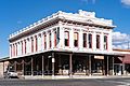
Odd Fellows Building in downtown Red Bluff (2020)
-
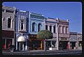
Main Street stores, 1987


See also
 In Spanish: Red Bluff para niños
