
Red River of the South facts for kids
Quick facts for kids Red River |
|
|---|---|

Red River looking east, north of Bonham, Texas: Texas is to the right, Oklahoma is on the left, and the border between the two states runs along the south (right) bank of the river.
|
|

Map of the Red River watershed
|
|
| Native name | Bah'hatteno |
| Other name(s) | Rivière Rouge (former French name), Río Colorado (former Spanish name) |
| Country | United States |
| States | Texas, Oklahoma, Arkansas and Louisiana |
| Physical characteristics | |
| Main source | Harmon County, Oklahoma 1,535 ft (468 m) 34°34′35″N 99°57′54″W / 34.57639°N 99.96500°W |
| River mouth | Atchafalaya River 30 ft (9.1 m) 31°01′10″N 91°44′52″W / 31.01944°N 91.74778°W |
| Length | 1,360 mi (2,190 km) |
| Basin features | |
| Basin size | 65,595 sq mi (169,890 km2) |
The Red River is a tributary of the Mississippi River. It begins in Texas, and flows through the states of Oklahoma, Arkansas, and Louisiana. It merges with the Mississippi River in Louisiana. The river's name comes from the red clay that is found along it. The Red is about 1,320 mi (2,120 km) long.
The biggest dam on the Red River is Denison Dam, which was created in 1943. It forms Lake Texoma. This lake covers 89,000 acres (360 square kilometers). There are also some other dams on the river's tributaries. At its end at the Mississippi River, it has a flow of 7,000 cubic feet (200 cubic meters) of water every second. In early 2009, the river experienced a series of catastrophic floods.
- Tyson, Carl N. The Red River in Southwestern History. Norman: University of Oklahoma Press, 1981. ISBN: 0-8061-1659-5
Images for kids
-

State Highway No. 78 Bridge at the Red River between Oklahoma and Texas, photographed on the Oklahoma side
-
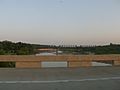
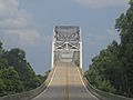
Crossing the Red River at the Texas–Oklahoma border from I-35
-
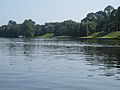
The Red River took a new channel near Natchitoches, Louisiana, and left behind Cane River Lake.
-
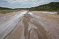
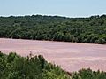
Salt beds in the Red River
-
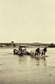
Crossing the North Fork of the Red River near Granite, Oklahoma, 1921.
-
Red River, Texas
-
Red River LA 2 Bridge, not the Jimmie Davis Bridge, atop the Red River between Bossier and Caddo parishes near Shreveport
-
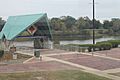
Popular pedestrian walkway along the Red River in Alexandria, Louisiana


See also
 In Spanish: Río Rojo (Misisipi) para niños
