
Red Run Covered Bridge facts for kids
Quick facts for kids Red Run Covered Bridge |
|
|---|---|
 |
|
| Coordinates | 40°10′34″N 76°05′00″W / 40.1762°N 76.0833°W |
| Locale | Lancaster County, Pennsylvania, United States |
| Characteristics | |
| Design | single span, double Burr arch truss |
| Total length | 107 feet (32.6 m) |
| History | |
| Constructed by | Elias McMellen |
| Construction begin | 1866 |

|
|

The Red Run Covered Bridge or Oberhaltzer's Covered Bridge is a covered bridge that once spanned the Muddy Creek in Lancaster County, Pennsylvania, United States. It was built in 1866 by Elias McMellen and is currently situated on private property next to the Red Run Campground. It is 107 feet long with a width of 15 feet and is also known as the Oberholzer's Covered Bridge.
The bridge has a single span, wooden, double Burr arch trusses design. It is painted red, the traditional color of Lancaster County covered bridges, on the outside. Both approaches to the bridge are painted in the traditional white color.
The bridge's WGCB Number is 38-36-10. Added in 1980, it is listed on the National Register of Historic Places as structure number 80003539. It is located at 40°10′34.2″N 76°5′0″W / 40.176167°N 76.08333°W (40.17617, -76.08333).
Dimensions
- Length: 107 feet (32.6 m) length or 128 feet (39 m) total length
- Width: 15 feet (4.6 m) total width
Gallery
-
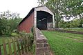
View of the front of the bridge
-
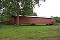
Side of the bridge
-
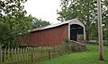
A three quarters view
-
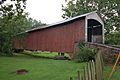
A closer view
-
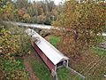
View from above towards river
-
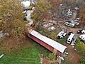
View from above towards campground


