Redfield, Arkansas facts for kids
Quick facts for kids
Redfield, Arkansas
|
|
|---|---|
|
City
|
|
| City of Redfield | |

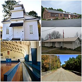
Clockwise from top: The Old Redfield School, Redfield City Hall, the Dollarway Road, Redfield Gymnasium, and the Lone Star Baptist Church
|
|

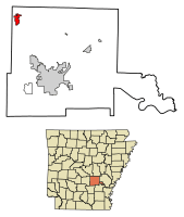
Location in Jefferson County and Arkansas
|
|
| Country | |
| State | |
| County | Jefferson |
| Township | Barraque |
| Founded | December 20, 1880 |
| Incorporated | October 18, 1898 |
| Founded by | James K. Brodie |
| Named for | Jared E. Redfield |
| Government | |
| • Type | Mayor–Council |
| Area | |
| • Total | 3.148 sq mi (8.15 km2) |
| • Land | 3.094 sq mi (8.01 km2) |
| • Water | 0.054 sq mi (0.14 km2) |
| Elevation | 302 ft (92 m) |
| Population
(2020)
|
|
| • Total | 1,505 |
| • Density | 486.43/sq mi (187.84/km2) |
| Time zone | UTC−06:00 (CST) |
| • Summer (DST) | UTC−05:00 (CDT) |
| ZIP code |
72132
|
| Area code | 501 |
| FIPS code | 05-58580 |
| GNIS feature ID | 58477 |
| Highways | |
| Major airport | Clinton Airport (LIT) |
Redfield is a small city in the Pine Bluff metropolitan area of northwestern Jefferson County in the U.S. state of Arkansas. The city is situated on the Union Pacific Railway (UP) and is approximately 23 miles (37 km) south of Little Rock, the state capital. As of the 2020 census, Redfield has a population of 1,505.
History
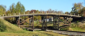
Following the arrival of the Little Rock, Mississippi River and Texas Railway, The municipality was incorporated by the Jefferson county court on October 18, 1898. Four historic properties have been listed on the National Register of Historic Places (NRHP): Dollarway Road (1974), West James Street Overpass (1995), Lone Star Baptist Church (2005), and Redfield School Historic District (2014).
To the area now known as Redfield came Auguste Le Noir de Serville, after serving with the French in the American Revolutionary War and being wounded at Yorktown. Killed by a falling tree in 1828, de Serville was buried with honors, and his funeral was attended by political and military notables.
Demographics
| Historical population | |||
|---|---|---|---|
| Census | Pop. | %± | |
| 1890 | 400 | — | |
| 1900 | 333 | −16.7% | |
| 1910 | 278 | −16.5% | |
| 1920 | 296 | 6.5% | |
| 1930 | 350 | 18.2% | |
| 1940 | 339 | −3.1% | |
| 1950 | 291 | −14.2% | |
| 1960 | 242 | −16.8% | |
| 1970 | 277 | 14.5% | |
| 1980 | 745 | 169.0% | |
| 1990 | 1,082 | 45.2% | |
| 2000 | 1,157 | 6.9% | |
| 2010 | 1,297 | 12.1% | |
| 2020 | 1,505 | 16.0% | |
| U.S. Decennial Census | |||
2020 census
| Race | Num. | Perc. |
|---|---|---|
| White (non-Hispanic) | 1,163 | 77.28% |
| Black or African American (non-Hispanic) | 213 | 14.15% |
| Native American | 5 | 0.33% |
| Asian | 13 | 0.86% |
| Pacific Islander | 3 | 0.2% |
| Other/Mixed | 64 | 4.25% |
| Hispanic or Latino | 44 | 2.92% |
As of the 2020 United States census, there were 1,505 people, 640 households, and 428 families residing in the city.
2010 census
As of the census of 2010, there were 1,297 people, 525 households and 369 families residing in the city. There were 581 housing units. The racial makeup of the city was 91.7% White, 4.8% Black or African American, 0.1% Native American, 0.5% Asian, 0% Pacific Islander, 0.6% from other races and 2.3% from two or more races. 1.8% of the population were Hispanic or Latino of any race. There were 525 households, out of which 29.9% had children under the age of 18 living with them, 52.2% were married couples living together, 13.3% had a female householder with no husband present, and 29.7% were non-families. 26.1% of all households were made up of individuals, and 22.9% had someone living alone who was 65 years of age or older. The average household size was 2.47 and the average family size was 2.95. The median age was 38.5 years.
Highways
Redfield is on Highway 365 linking White Hall and Little Rock, as well as Highway 46, linking the city to Sheridan. It is also on Interstate 530 (via Highway 46).
Education
Public education in northwest Jefferson county is administered by the White Hall School District. The school district manages two secondary schools (White Hall High School and White Hall Middle School) and four elementary schools. The M. A. Hardin Elementary School is located in Redfield.
Infrastructure
Redfield is on Highway 365 linking Pine Bluff and Little Rock, as well as Highway 46, linking it to Sheridan. It is also on Interstate 530 (via Highway 46).
See also
 In Spanish: Redfield (Arkansas) para niños


