
Reichenbach im Kandertal facts for kids
Quick facts for kids
Reichenbach im Kandertal
|
||
|---|---|---|
|
||
| Country | Switzerland | |
| Canton | Berne | |
| District | Frutigen-Niedersimmental | |
| Area | ||
| • Total | 125.77 km2 (48.56 sq mi) | |
| Elevation | 700 m (2,300 ft) | |
| Population
(Dec 2020 )
|
||
| • Total | 3,638 | |
| • Density | 28.926/km2 (74.918/sq mi) | |
| Postal code |
3713
|
|
| Localities | Griesalp, Kiental, Reichenbach | |
| Surrounded by | Aeschi bei Spiez, Diemtigen, Frutigen, Kandergrund, Kandersteg, Lauterbrunnen, Wimmis | |

Reichenbach im Kandertal is a village and municipality in the administrative district of Frutigen-Niedersimmental in the canton of Berne in Switzerland.

Geography

The village of Reichenbach im Kandertal lies in the valley of the Kander river, and the municipality includes a 4.5 km (2.8 mi) long section of this valley and the slopes on either side. However it also extends some 16.5 km (10.3 mi) up the valley of the Chiene river, from its confluence with the Kander to its source below the Schilthorn and the Blüemlisalp massif. From the upper part of the Chiene valley, rough tracks cross the Sefinafurgga and Hohtürli passes towards Lauterbrunnen and Kandersteg respectively, forming part of the Alpine Pass Route, a long-distance hiking trail across Switzerland between Sargans and Montreux.
The settlements of Aris, Faltsche, Mülenen, Reichenbach, Reudlen, Schwandi and Wengi all lie in or on the slopes of the Kander valley, whilst Griesalp, Kien, Kiental, Ramslauenen and Scharnachtal lie in the Chiene valley. The peaks of the Ärmighorn, Bütlasse, Drättehorn, Dreispitz, Drunengalm, Dündenhorn, Fromberghorn, Gspaltenhorn, Hundshorn, Morgenhorn, Niesen, Schwalmere, Wätterlatte and Wildi Frau are all within, or on, the municipal boundary.
The municipality has an area of 125.77 km2 (48.56 sq mi). Of this area, 49.41 km2 (19.08 sq mi) or 39.3% is used for agricultural purposes, while 30.83 km2 (11.90 sq mi) or 24.5% is forested. Of the rest of the land, 2.84 km2 (1.10 sq mi) or 2.3% is settled (buildings or roads), 1.42 km2 (0.55 sq mi) or 1.1% is either rivers or lakes and 41.25 km2 (15.93 sq mi) or 32.8% is unproductive land.
Of the built up area, housing and buildings made up 1.0% and transportation infrastructure made up 1.0%. Out of the forested land, 20.8% of the total land area is heavily forested and 2.7% is covered with orchards or small clusters of trees. Of the agricultural land, 9.6% is pastures and 29.4% is used for alpine pastures. All the water in the municipality is flowing water. Of the unproductive areas, 8.9% is unproductive vegetation, 21.7% is too rocky for vegetation and 2.3% of the land is covered by glaciers.
Images for kids
-
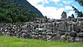
View of the Letzi Mülenen wall
-
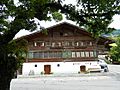
Gasthof Bären

.jpg)
See also
 In Spanish: Reichenbach im Kandertal para niños
