
Riau Islands facts for kids
Quick facts for kids
Riau Islands
Kepulauan Riau
|
|||
|---|---|---|---|
| Regional transcription(s) | |||
| • Jawi | كڤولاوان رياو | ||
     From top, left to right : Barelang Bridge, Scenery at Serasan Harbor in the Natuna Islands, Palmatak Island in the Anambas Islands, A view from Nyamuk in Siantan Timur, Beach in Bintan Island, Panoramic view of Batam Center Harbour
|
|||
|
|||
| Motto(s): | |||
.svg)
Location of Riau Islands in Indonesia
|
|||
| Country | |||
| Established | September 24, 2002 | ||
| Capital | Tanjung Pinang | ||
| Largest city | Batam | ||
| Area | |||
| • Total | 10,595.41 km2 (4,090.91 sq mi) | ||
| Area rank | 31st | ||
| Elevation | 2-5 m (−14.4 ft) | ||
| Highest elevation | 1,165 m (3,822 ft) | ||
| Lowest elevation | 0 m (0 ft) | ||
| Population
(2017)
|
|||
| • Total | 2,028,169 | ||
| • Rank | 27th | ||
| • Density | 191.41959/km2 (495.7745/sq mi) | ||
| • Density rank | 10th | ||
| Demonym(s) | Riau Islander Warga Kepulauan Riau (id) Kaum Kepulauan Riau (ms) |
||
| Demographics | |||
| • Ethnic groups | Malays (35.6%) Javanese (18.2%) Chinese (14.3%) Minangkabau (9.3%) Batak (8.1%) Buginese (2.2%) Banjarese (0.7%) |
||
| • Religion | Islam (77.51%) Protestantism (12.22%) Buddhist (7.57%) Roman Catholicism (2.46%) Confucianism (0.17%) Hinduism (0.05%) Others (0.02%) |
||
| • Languages | Indonesian (official) Malay (regional) Other languages: Javanese, Minangkabau, Batak, Buginese, Banjarese, Riau Hokkien, Hakka, Teochew, Yue, Mandarin, Tamil |
||
| Time zone | UTC+7 (Indonesia Western Time) | ||
| Postcodes |
29xxx
|
||
| Area codes | (62)77x | ||
| ISO 3166 code | ID-KR | ||
| Vehicle sign | BP | ||
| GRP per capita | $8,036 | ||
| HDI | |||
| HDI rank | 4th (2018) | ||


The Riau Islands (Indonesian: Kepulauan Riau) is a province of Indonesia. It comprises a total of 1,796 islands lying between the Malacca Strait, the Karimata Strait and the South China Sea. The province is located on one of the world's busiest shipping lanes, sharing water borders with Singapore, Malaysia, and Vietnam. Originally part of the province of Riau, the Riau Islands became Indonesia's third-youngest province in September 2002. The capital is Tanjung Pinang and the largest city is Batam.
The native inhabitants of the Riau Islands, called Orang Laut, formed the backbone of most Malay kingdoms from Srivijaya to the Johor Sultanate for the control of trade routes going through the Malacca Strait. After the fall of Malacca in 1511, the Riau islands became the centre of political power of the mighty Sultanate of Johor-Riau, based on Bintan Island, and were for long considered the centre of Malay culture.
Contents
Etymology
The origin of Riau Islands' name comes from the name Riau. Riau is allegedly derived from the word riuh, which in Malay means "loud" or "noisy". This is because the area of the Riau Islands was once a center of trade and crowd. Then this name developed with the use of the name Riau in the name of the Sultanate of Lingga. In the colonial period, the name Riau was spelled Riouw.
Geography and climate
Geography
The island of Batam, which lies within the central core group of islands (the Riau Archipelago), contains a majority of the province's population. Since becoming part of an economic zone with Singapore in 2006, it has experienced high population growth rates. Other highly populated islands in the Riau Archipelago include Bintan and Karimun, while the archipelago also includes islands such as Bulan and Kundur. There are around 3,200 islands in the province, which has its capital at Tanjung Pinang in the south of Bintan Island.
The Riau Islands province includes the Lingga Islands to the south of the main Riau Archipelago, while to the northeast lies the Tudjuh Archipelago, between Borneo and mainland Malaysia; the Tudjuh Archipelago consists of four distinct groups — the Anambas Islands, Natuna Islands, Tambelan islands and Badas Islands — which were attached to the new province, though not geographically part of the Riau Archipelago. The 2015 census count was 1,968,313, less than estimated, but it was still the second-fastest-growing province in Indonesia.
Riau Islands Province was established based on Law No. 25 of 2002 as the 32nd Province in Indonesia, covering Tanjungpinang City, Batam City, Bintan Regency, Karimun Regency, Natuna Regency, Lingga Regency and Anambas Regency. Overall the Riau Islands region consists of 5 districts and 2 cities, 42 subdistricts and 256 villages, with 2,408 big and small islands of which 40% have not been named and populated. The total area is 252,601 km2, of which 95% of it is ocean and only 5% is land area, with borders as follows:
| North | Vietnam and Cambodia |
| South | Bangka Belitung Islands and Jambi |
| West | Singapore, Malaysia and Riau |
| East | Malaysia, Brunei and West Kalimantan |
With a strategic geographical location (between the South China Sea, the Malacca Strait and the Karimata Strait) and supported by an abundance of natural potential, Riau Islands could become one of the economic growth centers for the Republic of Indonesia in the future, especially now that in some areas of the Riau Islands (Batam, Bintan and Karimun) a pilot project for the development of Special Economic Zones (Indonesian: Kawasan Ekonomi Khusus [KEK]) is being pursued through cooperation with the Singapore regime.
The implementation of the SEZ policy in Batam-Bintan-Karimun is a close cooperation between the central government and local government and the participation of the business world. This KEK/SER will be the nodes of the leading economic activity centers, supported by excellent service facilities and internationally competitive infrastructure capacity. Every business actor located within it will receive services and facilities of the highest quality that can compete with best practices from similar areas in Asia-Pacific.
Climate
As an archipelago, climatic conditions are affected by wind. Riau Islands Province has a wet tropical climate; there is a rainy season and a dry season interspersed with a transitional season with the lowest average temperature 20.4 °C. From November to February monsoon winds comes from the north, and between June to December the monsoon winds comes from the south. During the northern monsoon the wind velocity at sea can range from 20-30 knots; on land the wind can range from 3-15 knots. This causes potentially extreme weather in the Riau Islands, with rainfall of about 150-200 millimeters and wave height from 1.2 meters up to 3 meters.
History

From Srivijayan times until the 16th century, Riau was a central part of greater Malay kingdoms or sultanates, in the heart of what is often called the Malay World, which stretched from eastern Sumatra to Borneo. Orang Laut inhabited the islands and formed the backbone of most Malay kingdoms from Srivijaya to the Johor Sultanate for the control of trade routes going through the straits.
After the fall of Malacca in 1511, the Riau islands became the centre of political power of the mighty Sultanate of Johor or Johor-Riau, based on Bintan Island, and were for long considered the centre of Malay culture.
But history changed the fate of Riau as a political, cultural or economic centre when European powers struggled to control the regional trade routes and took advantage of political weaknesses within the sultanate. Singapore island, which had been for centuries part of the same greater Malay kingdoms and sultanates, and under direct control of the Sultan of Johor, came under control of the British.
The Anglo-Dutch Treaty of 1824 consolidated this new divide between north and south, with the British controlling all territories north of the Singapore strait and the Dutch controlling territories from Riau to Java.
After the European powers withdrew from the region, the new independent governments had to reorganise and find balance after inheriting 100 years of colonial boundaries. Before finding their current status, the territories of Indonesia, Malaysia, Singapore, Brunei and Borneo struggled and even came into military conflict against each other, and the Riau islands once again found themselves in the middle of a regional struggle.
The strong cultural unity of the region with Riau in the heart of this region never returned, and the line drawn by the British in 1819 remained, dividing the area into three new countries in 1965: Singapore, the Malaysian federation in the north, and Indonesia in the south.
Some level of unity returned in the Riau region for the first time after 150 years, with the creation of the Sijori Growth Triangle in 1989. But while bringing back some economical wealth to Riau, the Sijori Growth Triangle somewhat further broke the cultural unity within the islands. With Batam island receiving most of the industrial investments and dramatically developing into a regional industrial centre, it attracted hundreds of thousands of non-Malay Indonesian migrants, changing forever the demographic balance in the archipelago.
However, the upside of this demographic shift is that Batam is more multi-cultural and than how it was before, with a greater potential for better economic and educational development in future. Batam has become an industrial island with a booming tourism sector.
There have been various attempts at both independence and autonomy for this part of Indonesia since the founding of Indonesia in 1945.
Administrative divisions
This province is divided into five regencies (kabupaten) and two cities (kotamadya), listed below with their (provisional) populations at the 2010 Census:
| Name | Area (km2) | Population Census 2000 |
Population Census 2010 |
Population Est 2014 |
Capital | Notes | HDI 2018 Estimates |
|---|---|---|---|---|---|---|---|
| Batam City | 960.25 | 455,103 | 944,285 | 1,142,646 | Batam | includes Bulan, Galang and Rempang islands, as well as all of Batam Island |
0.805 (Very High) |
| Tanjung Pinang City | 144.56 | 142,929 | 187,359 | 226,716 | Tanjung Pinang | on Bintan Island | 0.783 (High) |
| Anambas Islands Regency (Kepulauan Anambas) |
590.14 | 28,510 | 37,411 | 45,270 | Tarempa | 0.675 (Medium) | |
| Bintan Regency | 1,318.21 | 110,068 | 142,300 | 172,192 | Bandar Seri Bentan | 0.734 (High) | |
| Karimun Regency | 912.75 | 171,405 | 212,561 | 257,212 | Tanjung Balai | including Karimun and Kundur Islands | 0.705 (High) |
| Lingga Regency | 2,266.77 | 79,451 | 86,244 | 104,361 | Daik | covering the Lingga Islands | 0.640 (Medium) |
| Natuna Regency | 2,009.04 | 52,741 | 69,003 | 83,498 | Ranai | 0.721 (High) |
Hubs
As the closest neighbour of Singapore and to realise that Soekarno–Hatta International Airport is fully utilised, Lion Air is developing hangars in Batam Island and Garuda Indonesia is developing a new airport, with runway and maintenance facilities so as to make a new air hub in Bintan Island.
Economy
As an island province, 96% of the province is covered with ocean. This condition is very conducive to the development of aquaculture enterprises ranging effort to use seeding cultivation technology and fishing.
Almost all areas in the province of Riau Islands has the potential to be processed into agricultural land and farms given fertile soil. The agricultural sector is a strategic sector, especially in the district of Bintan, Karimun and Batam. Besides the crops, and horticulture, other crops such as coconut, coffee, Gambier, pineapple and cloves are very well developed. Likewise, in the district of Bintan and Lingga very suitable for growing fruits and vegetables. In some of the island is suitable for oil palm plantations. One of the largest oil palm plantation in the Riau Islands are in the area of Tirta Madu.
Tourism
Tourism in the Riau Islands is one of the main sectors that help advance economic growth in the Riau Islands, Indonesia. Natural wealth, art, and culture is one of the important areas of tourism in the Riau Islands. The Riau Islands Nature has a tropical climate, with 2,408 islands of which 30% are uninhabited. The Lower Island of Anambas Islands is included in Asia's best tropical island version of CNN. In addition, Sisi Beach in Natuna has also become one of the best natural beaches in the world by Island magazine in 2006. Penyengat Island and Bintan Island are also examples of tourist destinations in the Riau Islands.
Demographics
Religion
| Religion in Riau Islands (2017) | ||||
|---|---|---|---|---|
| religion | percent | |||
| Islam | 77.51% | |||
| Protestantism | 12.22% | |||
| Buddhism | 7.57% | |||
| Roman Catholicism | 2.46% | |||
| Confucianism | 0.17% | |||
| Hinduism | 0.05% | |||
| Others | 0.02% | |||
Islam is the dominant religion in the province, with 77.51% of the total population identify themselves as Muslim. Other religions are Christianity, which forms 14.68% of the total population, Buddhism, which forms 7.51% of the total population, Hinduism, which forms 0.05% of the total population and Confucianism, which forms 0.17% of the total population.
Ethnic groups

Malay forms the dominant ethnic group of the province, with 35.6% of the total population identify themselves as Malay. The region is considered to be part of the Malay world. A subgroup of the Malays are called Orang laut. Orang laut are group of people who have a rich maritime culture, such as living in boats though in the present, many Orang laut have permanently settled on land. More broadly the term Orang Laut includes the various tribes and groups that settled on the islands and estuaries of the islands of Riau-Lingga, Tujuh Island, Batam Island, and the coast and islands off the coast of eastern Sumatra and the southern coast of the Malay Peninsula.
Orang laut are a tribe living in canoes or boat houses with major livelihoods as fish-seekers and other marine animals, such as sea cucumbers.
Other ethnic group are mostly immigrants coming from different parts of Indonesia.
Language
The language of the Riau Islands is known as Riau Malay. The Riau Islands are considered the birthplace of the modern Malay language, though it was the classical Malaccan Malay of the Johor court rather than Riau Malay that formed the basis of the standard language. Besides proper Riau Malay, there are several distinct varieties of Malay spoken in the province as well, especially those in Anambas Islands and Natuna Islands where they speak a form of Malay much more closely related to varieties of Malay in the eastern coast of Peninsular Malaysia like in Terengganu and Pahang as well as varieties spoken in Sarawak. Other languages spoken are Javanese, Sundanese, Batak and different varieties of Chinese, such as Hokkien, Hakka, Teochew and Cantonese.
Transportation
Sea

Due to the fact that the Riau Islands is an archipelagic province located in an archipelagic country, water transport becomes the main type of transportation. Inter-island connections are often contacted by water transport. This type of water transport includes ferries, boats, boats, canoes, speedboats, freight boats, pompongs, tankers, roro ships, and others. This ship consists of a ship owned by Pelni companies and private vessels. The main ports are in Batam, Bintan and Tanjungpinang. The ports include the Port of Sri Bintan Pura, Bulang Linggi Port, Nongsa Port, Telaga Punggur Harbor, Sekupang Port, and Batam Center Port. These ports have domestic destinations to the fellow cities of Riau Islands, cities in Sumatra, Java, Kalimantan, and even Sulawesi. International destinations are also being implemented, especially destinations to Malaysia, Singapore, and some yachts or tours from Japan, South Korea, Taiwan, Hong Kong, China, Qatar, UAE, the Philippines, Brunei Darussalam, Thailand, Cambodia and Vietnam.
Air
.jpg)
Air transport is the second major type of transportation in the Riau Islands after sea transportation. Bad weather, strong waves, and a long trip made some residents, especially residents of Anambas and Natuna Islands prefer using air transport rather than sea transportation. Six of the seven districts and cities in the Riau Islands already have an airport. Riau Islands has two international airports, namely Hang Nadim Airport in Batam and Raja Haji Fisabilillah International Airport in Tanjungpinang. Both airports have international flights to Malaysia, Singapore, China and Russia. Domestic airports consist of Ranai Airport, Dabo Airport, Sei Bati Airport, and Matak Airport. This domestic airport is connected to other cities/regencies Riau Islands, cities in Sumatra, Java, and Kalimantan. Construction of other domestic airports in the Riau Islands is the construction of Tambelan Airport in Bintan and the construction of Letung Airport in Anambas Islands.
Cuisine

Cuisine in the Riau Islands are mostly similar to the one in Peninsular Malaysia, owing to its similar culture. There are also some dishes that is influenced by other parts of Indonesia, such as Java. Due to its cultural diversity, the people of the Riau Islands has developed a unique dishes that cannot be found in other parts of Indonesia.
- Mie Tarempa - Mie Tarempa or Mie Siantan are made from yellow noodles from wheat flour, eggs, sprouts and pieces of sea fish fried with chilli spices. It can be easily found in the Anambas Islands, as well as its surrounding area.
- Laksa - Laksa or Lakse in local dialect is a kind of noodle food mixed with typical Chinese and Malay spice blend. Lakse has a round white and slightly thick noodle shape. The name of lakse is taken from Sanskrit which has a lot meaning. It shows that lute noodle is made with various spices. Lakse in the Riau Islands presented in several kinds, one of which is a typical Anambas lakse which is included in the category of lakse curry with a fatty and spicy sauce and rich in spices.
- Sup Ikan Batam - One of the most typical mackerel soups of Batam, popularly known as the Batam Fish Soup (Indonesian: Sup Ikan Batam). This Batam Fish soup is served with a slice of mackerel fish that had previously been separated from its bones. This piece of fish is smeared with egg whites to remove the fishy smell, then cooked with spices and mixed with starfruit and green tomatoes. Pieces of white or green mustard greens are also incorporated into this soup.
- Nasi Lemak - Nasi Lemak is rice cooked in coconut milk and spices such as ginger and sometimes herbs such as lemon grass for extra flavor, served with the usual condiments including fish chili or belgie crackers.
- Mie Lendir - This food consists of yellow noodles boiled with sprouts, and eaten with a boiled egg that is halved. This noodle is then watered with a thick peanut sauce. Its thick peanut sauce that make this food named Mie Lendir. Mie Lendir is usually sold in the morning, so the people of Riau Islands make this noodle as one of their breakfast menu.
- Bak kut teh (肉骨茶) - A Chinese-influenced dish found only in the region as well as neighboring Singapore and Malaysia. Bak kut teh means meat tea bone. Bak kut itself is pork ribs, while the word teh, whicn means tea in Hokkien, comes from either the dish brown sauce which is similar to the color of a tea, or that it was originally served with tea to mollify the taste.. This gravy is a pork broth, with spices such as garlic and strong pepper.
- Teh Tarik - Tea Tarik is a tea mixed with sweet milk. Foam that decorate the top of the tea is produced by pouring this herb from one glass to another. Tea Tarik is usually served and enjoyed with nasi lemak.
- Lempok durian - Dodol typical of Anambas has a distinctive taste and more tasty than that made in Sumatra or Kalimantan. Made from durian and granulated sugar, this traditionally made lempok starts at Rp 100,000 for a quarter kilogram and can be bought at restaurants and food stalls spread out in Tarempa or Letung.
- Gonggong - Believed to be named from the Chinese water god Gonggong (共工), this dish is the main specialty of the province. This food is usually processed by boiling and then eaten with special sauce. In Kepri itself, these marine animals are found in the waters of Lobam, Tanjung Uban, Bintan and Batam. The nutritional content of gong gong is very high, even some people believe gong food gong is able to install growth hormone, and increase vitality.
- Kue Deram-Deram - Deram dream is a traditional cake typical of Malay which is widely found in Tanjung Pinang especially in Penyengat Island. This cake looks like a donut yan has a hole in the middle. It's just the size is smaller and of course the resulting flavor is different.
- Lendot - Lendot is a typical Malay food that has a savory taste and a little spicy. Lendot made from sago flour, spices and kangkung then given additional extras such as snails, shrimp, squid or other seafood. Lendot is usually eaten hot or warm.
Images for kids
-
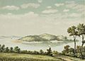
Pulau Penyengat (Lit: Wasp island), lithography of an original watercolour by J.C. Rappard. ca. 1883–1889.
-
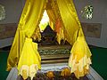
The Tomb of Puteri Hamidah, Queen of Sultan Mahmud Shah III.
-
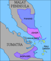
Anglo-Dutch Treaty of 1824
-

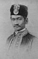
Ali Kelana, Crown Prince of Riau-Lingga, one of the founding fathers of the Roesidijah Club Riouw, the first modern organisation in the Netherlands East Indies. (taken in 1899)
-
Abdul Rahman II of Riau Lingga, the last sultan of Riau-Lingga sultanate. He was subsequently deposed by the Dutch and went into exile
-
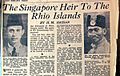
An article by H. M. Hassan entitled "The Singapore heir to the Rhio Islands" published in The Straits Times.
-
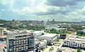
In the 1970s, the city of Batam started an industrial boom, which continues to this day
-
Tanjung Piayu, a scenic area in Batam
-
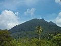
Tropical vegetation on Mount Ranai in eastern Great Natuna Island
-
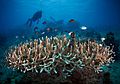
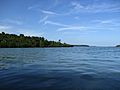
Coral Reef at Anambas
-
Tin mining in Singkep, Lingga Islands
-
PLTU Batam
-
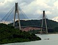
The cable-stayed Tengku Fisabilillah Bridge connecting Batam and Tonton, a part of the Barelang Bridge
-
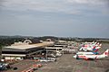
Hang Nadim International Airport in Batam, the busiest airport in the province
-
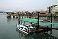
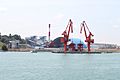
Tanjung Pinang Ferry Harbor
-
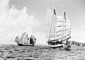
Chinese junks Sin Tong Heng and Tek Hwa Seng in the Sambu Island, Singapore Strait, c. 1936. The Chinese has inhabited the Riau Islands since the late 18th century
-
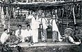
A troupe of local Riau Malay dancers performing the Joget Lambak. (taken in the late 19th century)
-
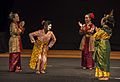
Mak Yong dancers in Bintan
-
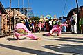
Malay men performing the Silat Pengantin traditional dance in a wedding ceremony at Lingga Islands
-
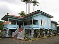
A typical Malay traditional house in the Taman Mini Indonesia Indah, Jakarta
-
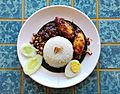
Nasi lemak Sambal Cumi, a variety of Nasi Lemak that can be found in the Riau Islands
-
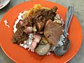
Nasi Campur, commonly consumed by the Chinese community in the Riau Islands
-
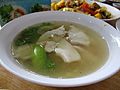
Sop Ikan Batam (Batam Fish Soup), a dish native to the city of Batam
-
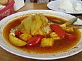
Sop Asam Pedas, a Malay-Minangkabau dish
-
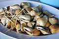
Siput Gongong, a common dish in Batam made of Laevistrombus canarium


.jpg)


_en_Tek_Hwa_Seng_bij_Poeloe_Samboe_TMnr_10010680.jpg)


See also
 In Spanish: Provincia de las Islas Riau para niños
