Richmond, Rhode Island facts for kids
Quick facts for kids
Richmond, Rhode Island
|
|
|---|---|

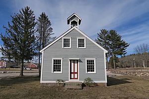
Bell School
Richmond Historical Society |
|

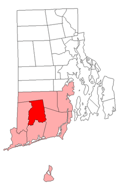
Location of Richmond in Washington County, Rhode Island
|
|
| Country | United States |
| State | Rhode Island |
| County | Washington |
| Area | |
| • Total | 40.8 sq mi (105.6 km2) |
| • Land | 40.6 sq mi (105.0 km2) |
| • Water | 0.2 sq mi (0.6 km2) |
| Elevation | 381 ft (116 m) |
| Population
(2020)
|
|
| • Total | 8,020 |
| • Density | 198/sq mi (76.4/km2) |
| Time zone | UTC−5 (Eastern (EST)) |
| • Summer (DST) | UTC−4 (EDT) |
| ZIP codes |
02812 (Carolina), 02832 (Hope Valley), 02836 (Kenyon), 02875 (Shannock), 02892 (West Kingston), 02894 (Wood River Junction), 02898 (Wyoming)
|
| Area code(s) | 401 |
| FIPS code | 44-61160 |
| GNIS feature ID | 1220089 |
| Website | http://www.richmondri.com |
Richmond is a town in Washington County, Rhode Island. The population was 8,020 at the 2020 census. It contains the villages of Alton, Arcadia, Barberville, Carolina, Hillsdale, Kenyon, Shannock, Tug Hollow, Usquepaug, Wood River Junction, Woodville, and Wyoming. Students in Richmond are part of the Chariho Regional School District.
Contents
History
The town of Richmond was originally part of the territory of Westerly, Rhode Island (1669 to 1747), which remained in dispute for several years between the British colonies of Rhode Island, Connecticut, and Massachusetts.
In 1665 Charles II, the King of England, dissolved the different charters of the three colonies in dispute, assumed governance, and renamed the area King’s County. In May 1669, the General Assembly of Rhode Island and Providence Plantations organized King’s County into the town of Westerly. After this the town of Westerly organized itself into four separate areas: Westerly, Charlestown, Richmond, and Hopkinton.
Richmond was incorporated as a separate and distinct town in 1747. It is bounded on the north by the town of Exeter, on the west by the Wood River, which separates it from Hopkinton, on the east by the towns of Exeter and South Kingstown, and on the south by the Pawcatuck River, which separates it from Charlestown.
Previous to both Colony and British rule the southern area of Rhode Island, encompassing Westerly, Charlestown, Richmond, and Hopkinton was inhabited and ruled by the Narragansett Indian Tribe. Records for Wood River Baptist Church go back to 1723, and it is mentioned in a 1709 deed.
Richmond is the site of one of the deadliest train disasters in American history. On April 19, 1873, there was a bridge washout in the village of Richmond Switch, which today is known as Wood River Junction. A passenger train approached, and, unaware of the bridge washout, ran off the tracks and into the water. 11 people are said to have died, although others were swept downstream and were unaccounted for.
The Washington County Fair, the largest fair in the state, has been held in Richmond since 1970.
In 2007 former resident Kirk W. House produced a historic photo book, Richmond, in the Arcadia Publishing "Images of America" series.
Geography
Richmond is 35 miles (56 km) south of the state's capital, Providence, Rhode Island. It is a mostly forested, landlocked community
According to the United States Census Bureau, the town has a total area of 40.8 square miles (105.6 km²), of which 40.6 square miles (105.0 km²) is land and 0.2 square miles (0.6 km²) is water.
Richmond borders Charlestown to the south, Exeter to the north and northeast, Hopkinton to the west, and South Kingstown to the southeast. Richmond is the only town in Washington County that does not border another county or the ocean.
A 2,359-acre (9.55 km2) tract in Richmond is owned by the state and managed for wildlife food and habitat as the Carolina Management Area. The Carolina Management Area is primarily forest (1,416 acres (5.73 km2)), but also includes wetlands and agricultural land.
Demographics
| Historical population | |||
|---|---|---|---|
| Census | Pop. | %± | |
| 1790 | 1,760 | — | |
| 1800 | 1,368 | −22.3% | |
| 1810 | 1,330 | −2.8% | |
| 1820 | 1,423 | 7.0% | |
| 1830 | 1,363 | −4.2% | |
| 1840 | 1,361 | −0.1% | |
| 1850 | 1,784 | 31.1% | |
| 1860 | 1,964 | 10.1% | |
| 1870 | 2,064 | 5.1% | |
| 1880 | 1,949 | −5.6% | |
| 1890 | 1,669 | −14.4% | |
| 1900 | 1,596 | −4.4% | |
| 1910 | 1,633 | 2.3% | |
| 1920 | 1,301 | −20.3% | |
| 1930 | 1,535 | 18.0% | |
| 1940 | 1,629 | 6.1% | |
| 1950 | 1,772 | 8.8% | |
| 1960 | 1,986 | 12.1% | |
| 1970 | 2,625 | 32.2% | |
| 1980 | 4,018 | 53.1% | |
| 1990 | 5,351 | 33.2% | |
| 2000 | 7,222 | 35.0% | |
| 2010 | 7,708 | 6.7% | |
| 2020 | 8,020 | 4.0% | |
| U.S. Decennial Census | |||
As of the census of 2000, there were 7,222 people, 2,537 households, and 2,034 families residing in the town. The population density was 178.1 people per square mile (68.7/km2). There were 2,620 housing units at an average density of 64.6 per square mile (24.9/km2). The racial makeup of the town was 96.97% White, 0.40% African American, 0.91% Native American, 0.44% Asian, 0.19% from other races, and 1.08% from two or more races. Hispanic or Latino of any race were 1.23% of the population.
There were 2,537 households, out of which 40.2% had children under the age of 18 living with them, 69.3% were married couples living together, 7.5% had a female householder with no husband present, and 19.8% were non-families. 14.3% of all households were made up of individuals, and 4.4% had someone living alone who was 65 years of age or older. The average household size was 2.84 and the average family size was 3.14.
In the town, the population was spread out, with 27.9% under the age of 18, 6.1% from 18 to 24, 34.4% from 25 to 44, 24.5% from 45 to 64, and 7.0% who were 65 years of age or older. The median age was 36 years. For every 100 females, there were 100.7 males. For every 100 females age 18 and over, there were 97.9 males.
The median income for a household in the town was $59,840, and the median income for a family was $64,688. Males had a median income of $41,357 versus $29,115 for females. The per capita income for the town was $22,351. About 1.9% of families and 3.0% of the population were below the poverty line, including 4.2% of those under age 18 and 4.3% of those age 65 or over.
National Register of Historic Places listings in Richmond
- Carolina Village Historic District
- John Hoxsie House
- Shannock Historic District
- Wyoming Village Historic District
Adjacent Towns
 |
Exeter |  |
||
| Hopkinton | Exeter, South Kingstown | |||
| Charlestown |
- Google, Inc. Google Maps – Richmond, Rhode Island [map]. Cartography by Tele Atlas.
Notable people
- Billy Gilman (born 1988), country artist and runner-up of Season 11 of The Voice. Gilman is from the village of Hope Valley and is often mistaken as being from Hopkinton because most of the village is located in that town
- Thomas A. Tefft (1826–1859), architect
- Frank J. Williams (born 1940), Chief Justice of the Supreme Court of Rhode Island (2001–2009)
See also
 In Spanish: Richmond (Rhode Island) para niños

