
River Camel facts for kids
Quick facts for kids River Camel |
|
|---|---|

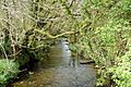
The Camel valley in winter. Taken from between Pendavey bridge and Polbrock looking upstream.
|
|

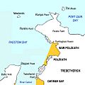
Sketch map of the River Camel and its tributaries
|
|
| Native name | Dowr Kammel |
| Country | United Kingdom |
| Region | Cornwall |
| Physical characteristics | |
| Main source | Hendraburnick Down Bodmin Moor 218 m (715 ft) 50°39′33″N 4°38′29″W / 50.65917°N 4.64139°W |
| River mouth | Padstow Bay Padstow, North Cornwall coast 50°33′02″N 4°53′37″W / 50.55056°N 4.89361°W |
| Length | 48 km (30 mi) |
| Basin features | |
| Basin size | 413 km2 (159 sq mi) |
| Tributaries |
|
The River Camel is a river in Cornwall, UK. It rises on the edge of Bodmin Moor and together with its tributaries drains a considerable part of North Cornwall. The river issues into the Atlantic Ocean having covered a distance of approximately 30 miles. The river is tidal as far upstream as Egloshayle and is popular for sailing, birdwatching and fishing.
Geology
The River Camel rises on the edge of Bodmin Moor, an area which forms part of the granite spine of Cornwall. The river's course is then through upper and middle Devonian rocks, predominantly slates. The only active quarry in the River Camel catchment area is Delabole Quarry. There are some disused mines for a variety of metals in the area. The catchment area of the River Camel covers a total of 413 km² on the western side of Bodmin Moor, and is mainly Devonian slates and granite, with some shales and sandstones.
Images for kids
-
The young River Camel at Slaughterbridge upstream of Camelford
-
Sketch map of the River Camel estuary
-
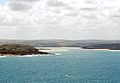
The estuary of the River Camel seen from Pentire Point with Trebetherick Point in the foreground.
-
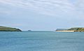
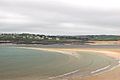
The estuary of the River Camel looking seaward from Padstow
-
The Doom Bar sandbank extends across the Camel estuary
-
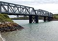
The Camel Trail crosses Petherick Creek on this bridge which formerly carried the North Cornwall Railway


