
River Tay facts for kids
Quick facts for kids River Tay |
|
|---|---|

Looking upstream (north) along the Tay from the centre of Perth
|
|
| Other name(s) | Tatha |
| Country | United Kingdom |
| Constituent country | Scotland |
| Physical characteristics | |
| Main source | Allt Coire Laoigh Ben Lui, Scottish Highlands, UK 720 m (2,360 ft) 56°23′07″N 4°47′36″W / 56.38528°N 4.79333°W |
| River mouth | Firth of Tay, North Sea Between Perth, Scotland and Dundee, Scotland, UK 0 m (0 ft) 56°21′18″N 3°17′54″W / 56.35500°N 3.29833°W |
| Length | 188 km (117 mi) |
| Basin features | |
| Basin size | 4,970 km2 (1,920 sq mi) |
| Tributaries |
|
The River Tay (Scottish Gaelic: Tatha) is the longest river in Scotland and the seventh-longest in the United Kingdom. The Tay originates in western Scotland on the slopes of Ben Lui (Scottish Gaelic: Beinn Laoigh), then flows easterly across the Highlands, through Loch Dochart, Loch Iubhair and Loch Tay, then continues east through Strathtay (see Strath), in the centre of Scotland, then southeasterly through Perth, where it becomes tidal, to its mouth at the Firth of Tay, south of Dundee. It is the largest river in the UK by measured discharge. Its catchment is approximately 2,000 square miles (5,200 km2), the Tweed's is 1,500 square miles (3,900 km2) and the Spey's is 1,097 square miles (2,840 km2).
Images for kids
-
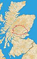
Catchment of the River Tay within Scotland.
-
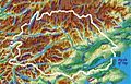
Catchment of the River Tay.
-
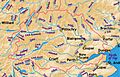
Tributaries of the River Tay.
-
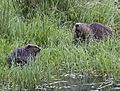
Tayside beaver with her kit. Courtesy of Ray Scott 2010.


See also
 In Spanish: Río Tay para niños
