
Tiber River facts for kids
Quick facts for kids Tiber (Tevere) |
|
| River | |
 The Tiber in Rome
|
|
| Country | Italy |
|---|---|
| Regions | Emilia-Romagna, Tuscany, Umbria, Lazio |
| Provinces | Forlì-Cesena, Arezzo, Perugia, Terni, Viterbo, Rieti, Roma |
| Comuni | Pieve Santo Stefano, Sansepolcro, Città di Castello, Umbertide, Orte, Rome |
| Tributaries | |
| - left | Chiascio, Nera, Aniene |
| - right | Nestore, Paglia |
| City | Rome |
| Source | Mount Fumaiolo |
| - location | Forlì-Cesena, Emilia-Romagna, Italy |
| - elevation | 1,268 m (4,160 ft) |
| - coordinates | 43°47′13″N 12°04′40″E / 43.78694°N 12.07778°E |
| Mouth | Tyrrhenian Sea |
| - location | Ostia, Lazio, Italy |
| - elevation | 0 m (0 ft) |
| - coordinates | 41°44′26″N 12°14′00″E / 41.74056°N 12.23333°E |
| Length | 405 km (252 mi) |
| Basin | 17,375 km² (6,709 sq mi) |
| Discharge | for Rome |
| - average | 231 m³/s (8,158 cu ft/s) |
The Tiber (Latin: Tiberis, Italian: Tevere) is the third-longest river in Italy, rising in the Apennine Mountains in Emilia-Romagna and flowing mainly through Umbria and Lazio to the Tyrrhenian Sea, between Ostia and Fiumicino.
The river is well-known because the city of Rome was founded on its eastern banks.
Geography
The Tiber river has a length of 405 km (252 mi), and a drainage basin with an area of approximately 17,375 km2 (6,709 sq mi), almost 5% of the territory of the country.
It is the third longest river of Italy, after the Po and the Adige rivers, and the second by drainage basin after the Po.
| River | Length (km) | Watershed (km²) |
|---|---|---|
| Po | 652 | 74,970 |
| Adige | 410 | 12,200 |
| Tiber | 405 | 17,375 |
Course
The Tiber starts near the town of Balze, Verghereto comune in the southwestern end of the Forlì-Cesena province, in the southern side of Monte Fumaiolo. The source of the river is formed by two springs that are 10 m (33 ft) from each other in a forest on the mountain at an elevation of 1,268 m (4,160 ft) above sea level.
The Tiber flows through Emilia-Romagna about 4 kilometres (2.5 miles) and then it gets into Tuscany where flows through Pieve Santo Stefano and Sansepolcro. Between these two localities there is a dam with a large reservoir that is named as Montedoglio Lake (Italian: Lago di Montedoglio). From here, the river flows through a wide plain (Val Tiberina) and gets in the Perugia province (Umbria) and flows through the towns of Città di Castello and Umbertide.
To the south of Torgiano, it is joined by its left side by the Chiascio river and then, in the Marsciano dam, by the Nestore river by its right side. Soon another right tributary, the Paglia, joins the Tiber.
The river forms the border between the Umbria (province of Terni) and Lazio (province of Viterbo) regions. Near the city of Orte, it is joined by the left side by its main tributary, the Nera river.
It flows through the Lazio region (Viterbo, Rieti and Rome provinces) and is joined by the Aniene river, flows through the city of Rome and, finally, into the Tyrrhenian Sea between Ostia and Fiumicino.
Main tributaries
The main tributaries are:
| Tributary | Length | Discharge |
|---|---|---|
| Left tributaries | ||
| Chiascio | 82 km | 19 m³/s |
| Nera | 116 km | 168 m³/s |
| Aniene | 99 km | 35 m³/s |
| Right tributaries | ||
| Nestore | 64 km | 11 m³/s |
| Paglia | 86 km | 11 m³/s |
Discharge
The average yearly discharge (volume of water which passes through a section of the river per unit of time) of the Tiber is 240 m3/s (8,500 cu ft/s) at its mouth.
The mean monthly discharges (in m³) for 2011 in Rome were:
| 644 | 548 | 491 | 316 | 205 | 175 | 97 | 84 | 91 | 324 | 897 | 840 |
| Jan | Feb | Mar | Apr | May | Jun | Jul | Aug | Sep | Oct | Nov | Dic |
Gallery

-
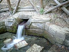
Spring of river Tiber on Monte Fumaiolo.
-
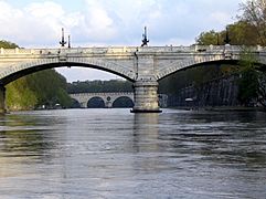
The river Tiber in Rome.
-
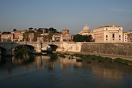
View of the Tiber looking towards the Vatican City.


.jpg)
Related pages
Images for kids
-
Highest level of Tiber for 40+ years, 13 December 2008, at Tiber Island
-
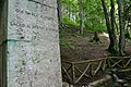
Column built by Mussolini near the source of Tiber
-
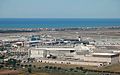
ome Fiumicino airport is also located near the river.
-
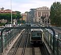
rain going over the river
-
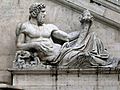
Roman representation of Tiber as a god (Tiberinus) with cornucopia at the Campidoglio, Rome


See also
 In Spanish: Tíber para niños
