
Robbinsville Township, New Jersey facts for kids
Quick facts for kids
Robbinsville Township, New Jersey
|
|
|---|---|
|
Township
|
|
| Township of Robbinsville | |

Robbinsville Town Center along Route 33
|
|
| Motto(s):
"Be at the Center of it All"
|
|

Location in Mercer County and the state of New Jersey.
|
|

Census Bureau map of Washington Township, Mercer County, New Jersey (currently known as Robbinsville Township)
|
|

Robbinsville Township, New Jersey
Location in Mercer County, New Jersey

Robbinsville Township, New Jersey
Location in New Jersey

Robbinsville Township, New Jersey
Location in the United States
|
|
| Country | |
| State | |
| County | |
| Incorporated | March 15, 1859, as Washington Township |
| Renamed | January 1, 2008, as Robbinsville Township |
| Named for | George R. Robbins |
| Government | |
| • Type | Faulkner Act (mayor–council) |
| • Body | Township Council |
| Area | |
| • Total | 20.58 sq mi (53.30 km2) |
| • Land | 20.44 sq mi (52.94 km2) |
| • Water | 0.14 sq mi (0.36 km2) 0.68% |
| Area rank | 139th of 565 in state 5th of 12 in county |
| Elevation | 121 ft (37 m) |
| Population | |
| • Total | 15,476 |
| • Rank | 168th of 564 in state 9th of 12 in county |
| • Density | 757.1/sq mi (292.3/km2) |
| • Density rank | 413th of 564 in state 11th of 12 in county |
| Time zone | UTC−05:00 (Eastern (EST)) |
| • Summer (DST) | UTC−04:00 (Eastern (EDT)) |
| ZIP Code |
08691
|
| Area code(s) | 609 |
| FIPS code | 3402163850 |
| GNIS feature ID | 0882122 |
Robbinsville Township is a township in Mercer County, New Jersey, United States. The township is part of the New York Metropolitan area as defined by the United States Census Bureau, but directly borders the Philadelphia metropolitan area and is part of the Federal Communications Commission's Philadelphia Designated Market Area. As of the 2010 United States Census, the township's population was 13,642, reflecting an increase of 3,367 (+32.8%) from the 10,275 counted in the 2000 Census, which had in turn increased by 4,460 (+76.7%) from the 5,815 counted in the 1990 Census. The township is named for George R. Robbins, who served in the United States House of Representatives from 1855 to 1859 and lived in the area.
What is now Robbinsville Township was originally incorporated as Washington Township (named for George Washington) by an act of the New Jersey Legislature on March 15, 1859, from portions of East Windsor Township. On November 6, 2007, voters approved by a vote of 1,816 to 693 a measure that changed the township's name from Washington Township (the name of five other municipalities in New Jersey) to Robbinsville, named after a settlement within the township. The official changeover took place January 1, 2008, as signs and other items with "Washington" on them began to be changed.
Robbinsville Township is known for reaching the Little League Softball World Series in four of the seven years from 2008 to 2014, the only program in the nation to do so. The team won the championship in 2014 with a 22-0 postseason record and a 4–1 win against Bossier City, Louisiana in the tournament final. the team was featured in a story by ESPNw as a perennial softball powerhouse.
Contents
Geography
According to the United States Census Bureau, the township as of 2010 had a total area of 20.491 square miles (53.072 km2), including 20.316 square miles (52.618 km2) of land and 0.175 square miles (0.454 km2) of water (0.86%). The township borders East Windsor Township, Hamilton Township, and West Windsor Township in Mercer County; and Allentown, Millstone Township and Upper Freehold Township in Monmouth County. Unincorporated communities, localities and place names located partially or completely within the township include Allens Station, Carsons Mills, Hillside Terrace, Meadows Terrace, New Canton, New Sharon, Pages Corners, and Windsor.
Demographics
| Historical population | |||
|---|---|---|---|
| Census | Pop. | %± | |
| 1860 | 1,279 | — | |
| 1870 | 1,294 | 1.2% | |
| 1880 | 1,281 | −1.0% | |
| 1890 | 1,126 | −12.1% | |
| 1900 | 1,157 | 2.8% | |
| 1910 | 1,090 | −5.8% | |
| 1920 | 1,161 | 6.5% | |
| 1930 | 1,347 | 16.0% | |
| 1940 | 1,365 | 1.3% | |
| 1950 | 1,843 | 35.0% | |
| 1960 | 2,156 | 17.0% | |
| 1970 | 3,311 | 53.6% | |
| 1980 | 3,487 | 5.3% | |
| 1990 | 5,815 | 66.8% | |
| 2000 | 10,275 | 76.7% | |
| 2010 | 13,642 | 32.8% | |
| 2020 | 15,476 | 13.4% | |
| Population sources: 1860-1920 1860-1870 1870 1880-1890 1890-1910 1910-1930 1930-1990 2000 2010 2020 |
|||
Census 2010
As of the census of 2010, there were 13,642 people, 5,087 households, and 3,591 families residing in the township. The population density was 671.5 per square mile (259.3/km2). There were 5,277 housing units at an average density of 259.7 per square mile (100.3/km2)*. The racial makeup of the township was 81.59% (11,131) White, 3.12% (426) Black or African American, 0.10% (13) Native American, 12.67% (1,729) Asian, 0.00% (0) Pacific Islander, 0.71% (97) from other races, and 1.80% (246) from two or more races. [[Hispanic (U.S. Census)|Hispanic or Latino of any race were 4.13% (564) of the population.
There were 5,087 households out of which 41.7% had children under the age of 18 living with them, 60.0% were married couples living together, 7.7% had a female householder with no husband present, and 29.4% were non-families. 25.8% of all households were made up of individuals, and 8.6% had someone living alone who was 65 years of age or older. The average household size was 2.66 and the average family size was 3.26.
In the township, the population was spread out with 28.7% under the age of 18, 4.3% from 18 to 24, 28.4% from 25 to 44, 28.8% from 45 to 64, and 9.7% who were 65 years of age or older. The median age was 39.2 years. For every 100 females there were 91.3 males. For every 100 females ages 18 and old there were 87.8 males.
The Census Bureau's 2006-2010 American Community Survey showed that (in 2010 inflation-adjusted dollars) median household income was $92,440 (with a margin of error of +/- $11,773) and the median family income was $124,816 (+/- $10,353). Males had a median income of $96,156 (+/- $4,577) versus $65,327 (+/- $8,597) for females. The per capita income for the borough was $44,149 (+/- $2,813). About 2.7% of families and 3.1% of the population were below the poverty line, including 3.7% of those under age 18 and 4.9% of those age 65 or over.
Census 2000
As of the 2000 United States Census there were 10,275 people, 4,074 households, and 2,815 families residing in the township. The population density was 501.8 people per square mile (193.7/km2). There were 4,163 housing units at an average density of 203.3 per square mile (78.5/km2). The racial makeup of the township was 91.00% White, 2.89% African American, 0.14% Native American, 4.31% Asian, 0.55% from other races, and 1.11% from two or more races. Hispanic or Latino of any race were 2.72% of the population.
There were 4,074 households, out of which 36.0% had children under the age of 18 living with them, 59.8% were married couples living together, 7.3% had a female householder with no husband present, and 30.9% were non-families. 26.4% of all households were made up of individuals, and 7.4% had someone living alone who was 65 years of age or older. The average household size was 2.52 and the average family size was 3.09.
In the township the population was spread out, with 26.1% under the age of 18, 3.7% from 18 to 24, 37.9% from 25 to 44, 22.6% from 45 to 64, and 9.7% who were 65 years of age or older. The median age was 37 years. For every 100 females, there were 91.4 males. For every 100 females age 18 and over, there were 87.7 males.
The median income for a household in the township was $71,377, and the median income for a family was $90,878. Males had a median income of $61,589 versus $44,653 for females. The per capita income for the township was $35,529. About 2.5% of families and 3.7% of the population were below the poverty line, including 4.1% of those under age 18 and 5.0% of those age 65 or over.
Development
Robbinsville Town Center, near the intersection of U.S. Route 130 and Route 33, is a mix of about 1,000 housing units, including loft-style condominiums, townhouses, duplexes, single-family homes, and real estate space.
Plans are underway to redevelop the portion of the township which lies to the south of Route 33, between the Hamilton Township border and U.S. Route 130. In December 2010, the state approved designating this property as an area in need of development, which allows the township to draft a plan and appoint a redeveloper to revive stalled construction projects there.
A planned Burger King restaurant at the corner of U.S. Route 130 south and Main Street has similarly generated concerns from neighbors. It has been since replaced with a Taco Bell restaurant which was scheduled to be completed in late 2014 but opened on April 15, 2015.
Robbinsville is home to a large warehouse colony, located on West Manor Way, just adjacent to the entrances and exit ramps to exits 7 and 8 off of Interstate 195. It is home to a variety of companies' distribution centers, including Scholastic Books, JDSU, Sleepy's, and Grainger Products. The Robbinsville Field House is a large membership gym located at the entrance to the warehouse colony near Route 526. An Amazon.com Fulfillment Center warehouse opened in the Matrix Business Park off of CR 539 in July 2014.
Transportation
Roads and highways

As of May 2010[update], the township had a total of 99.99 miles (160.92 km) of roadways, of which 78.26 miles (125.95 km) were maintained by the municipality, 8.16 miles (13.13 km) by Mercer County, 8.37 miles (13.47 km) by the New Jersey Department of Transportation and 5.20 miles (8.37 km) by the New Jersey Turnpike Authority.
_from_the_overpass_for_the_ramp_to_northbound_Interstate_95_(New_Jersey_Turnpike)_in_Robbinsville_Township,_Mercer_County,_New_Jersey.jpg)
Four major U.S./State/Interstate routes pass through the township: the New Jersey Turnpike (Interstate 95), Interstate 195 (the Central Jersey Expressway), U.S. Route 130 and Route 33. County routes that pass through include County Route 526 (which passes through the center of the township) and both County Route 524 and County Route 539 (Old York Road), which travel along the southeastern border of the township.
Interstate 195 is a major artery that connects Trenton to the Jersey Shore and the New Jersey Turnpike. Interchange 7A (for the Turnpike) is located in the township, with a 13-lane toll gate. Interstate 195 also provides access to Six Flags Great Adventure in Jackson Township.
Public transportation
NJ Transit provides bus service to and from Trenton on the 606 route.
Robbinsville Township is home to Trenton-Robbinsville Airport (identifier N87), an uncontrolled general aviation airport, with a 4,275-foot (1,303 m) long runway. The airport averages 30,000 aircraft operations per year.
Points of interest
Wineries
Restaurants
- Papa's Tomato Pies
- De Lorenzo's Tomato Pies
Religious institutions

- Swaminarayanan Akshardham – the world's largest Hindu temple, inaugurated in 2014
Education
The Robbinsville Public School District serves students in kindergarten through twelfth grade. Schools in the district (with 2018–19 enrollment data from the National Center for Education Statistics) are Sharon Elementary School with 1,058 students in grades PreK-4, Pond Road Middle School with 1,031 students in grades 5-8 and Robbinsville High School with 1,053 students in grades 9-12.
Prior to the 2006–07 school year, high school students from here were sent to Lawrence High School in Lawrence Township as part of a now-ended sending/receiving relationship with the Lawrence Township Public Schools. Robbinsville High School serves all of Robbinsville Township's high school students on site and graduated its first class of 150 students in June 2008.
Eighth grade students from all of Mercer County are eligible to apply to attend the high school programs offered by the Mercer County Technical Schools, a county-wide vocational school district that offers full-time career and technical education at its Health Sciences Academy, STEM Academy and Academy of Culinary Arts, with no tuition charged to students for attendance.
Notable people
People who were born in, residents of, or otherwise closely associated with Robbinsville Township include:
- Shobhan Bantwal (born 1950), Indian American writer.
- Ross Colton (born 1996), centre for the Tampa Bay Lightning (NHL) who scored the series-clinching goal in Game 5 of the 2021 Stanley Cup Finals.
- Frank Eliason (born 1972), corporate executive and author.
- John Friedberg (born 1961), fencer who competed in the team sabre event at the 1992 Summer Olympics in Barcelona.
- Elijah C. Hutchinson (1855–1932), represented New Jersey's 4th congressional district from 1915–1923.
- Robert "Bobby" Smith (born 1951), retired U.S. soccer defender and National Soccer Hall of Fame member, owner of Bob Smith Soccer Academy in Robbinsville Township.
Images for kids
-
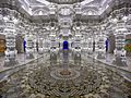
Swaminarayanan Akshardham in Robbinsville, is one of the world's largest Hindu temples.

See also
 In Spanish: Municipio de Robbinsville (Nueva Jersey) para niños
