
Rock Creek (Potomac River tributary) facts for kids
Quick facts for kids Rock Creek |
|
|---|---|

Rock Creek, Washington, D.C.
|
|
| State | Maryland |
| County | Montgomery County, Maryland |
| Cities | Rockville, Maryland Washington, D.C. |
| Physical characteristics | |
| Main source | Laytonsville, Maryland 560 feet (170 m) 39°11′56″N 77°08′20″W / 39.1990012°N 77.1388044°W |
| River mouth | Potomac River 0 feet (0 m) 38°53′58″N 77°03′26″W / 38.899556°N 77.0572°W |
| Length | 32.6 miles (52.5 km) |
| Basin features | |
| Basin size | 76.5 square miles (198 km2) |
| Landmarks | Rock Creek Park |
| Waterbodies | Lake Needwood |
Rock Creek is a free-flowing tributary of the Potomac River that empties into the Atlantic Ocean via the Chesapeake Bay. The 32.6-mile (52.5 km) creek drains about 76.5 square miles (198 km2). Its final quarter-mile (400 m) is affected by tides.
Geography
The creek rises from a spring near Laytonsville in Montgomery County, in the U.S. state of Maryland, and joins the Potomac near Georgetown and the Watergate complex in Washington, D.C. It enters Rock Creek Regional Park in Maryland's Derwood–Rockville area and flows southward to the D.C. boundary. About 9 miles (14 km) of the creek flow through Rock Creek Park in Washington, where it is fed by several small creeks (Piney Branch, Pinehurst Branch, Broad Branch, Soapstone Branch, and Luzon Branch) and numerous storm sewers.
The Chesapeake and Ohio Canal joins Rock Creek in Georgetown; the creek's mouth is the canal's eastern terminus. Just below this confluence, the Canal Company in 1831 completed a mole, causeway, and waste weir. This area, which the company dubbed "Rock Creek Basin", silted up and was dredged several times for the Canal's use. The creek (and the canal) empty into the Potomac River at the Tidewater Lock.
The Maryland portion of the watershed comprises the second-largest watershed in Montgomery County, about 60 sq mi (160 km2). About 21 percent of the creek's watershed is in Washington. Total land usage in the watershed is 896 acres (3.63 km2) of wetlands or water, 22,272 acres (90.13 km2) of residential and commercial areas, 15,488 acres (62.68 km2) of forest or grasslands, and 10,304 acres (41.70 km2) of agricultural areas. The creek has a fairly steep gradient, with rapid changes in elevation. The man-made Lake Needwood is located on the creek, north of Rockville.
The conditions at the Rock Creek are monitored by the USGS.
Water quality and restoration

In Maryland, most of the northern Rock Creek watershed has good to excellent water quality, according to studies conducted by the county government. In 2004, to preserve water quality in partially developed areas, the county imposed restrictions on development (i.e., designation of "Special Protection Areas") in parts of this sub-watershed. The southern portion of the Maryland watershed is highly urbanized. Most of this portion of the creek and its tributaries have poor water quality. As of 2018 the county has completed several stream restoration projects throughout the watershed, and has additional projects planned or under construction.
The D.C. segment of Rock Creek also has poor water quality. In addition to typical urban stormwater pollution problems such as runoff from streets and other impervious surfaces, the creek has high bacteria levels due to combined sewer overflows (CSOs). The D.C. government, which has a stormwater discharge permit from the United States Environmental Protection Agency, is improving its stormwater management to raise water quality in Rock Creek. In 2009, the District of Columbia Water and Sewer Authority began a planned two-year effort to replace portions of the combined sewer with separate storm sewers, and so eliminate CSO-related problems in the creek.
Fish species observed in Rock Creek and its tributaries include eastern blacknose dace, bluntnose minnow, yellow bullhead, satinfin shiner, swallowtail shiner, longnose dace, and American eel.
Restoration projects

In 2006, the National Park Service finished a project to remove or bypass eight fish barriers in the creek by adding a fish ladder to bypass the 1905 Peirce Mill Dam, modifying historic fords, and removing abandoned sewage lines and fords. The effort is designed to restore American shad, river herring, and other migratory fish to the creek and their historic upriver spawning grounds. An estimated two million fish migrate up the creek each year.
The D.C. government completed a restoration project on the Milkhouse Run and Bingham Run tributaries in 2013. As of 2014, ongoing restoration projects in the watershed include the Broad Branch and Klingle Run tributaries.
Tributaries
(Listed in order from the mouth upstream)
- In D.C.
- Dumbarton Oaks
- Normanstone Creek
- Klingle Valley Creek (also called Klingle Creek, Klingle Run)
- Piney Branch
- Melvin Hazen Valley Branch
- Broad Branch
- Soapstone Branch
- Luzon Branch
- Milkhouse Run
- Bingham Run
- Pinehurst Branch
- Fenwick Branch
- Portal Branch
- In Maryland
- Donnybrook Tributary
- Coquelin Run
- Capitol View Tributary
- Kensington Heights Branch
- Stoney Creek
- Alta Vista Tributary (formerly Bethesda Run)
- Luxmanor Branch
- Stoneybrook Tributary
- Josephs Branch
- Turkey Branch
- Sycamore Creek
- Croydon Park Tributary
- Southlawn Branch
- Williamsburg Run
- North Branch (Lake Bernard Frank)
- Lake Needwood (in-line on Rock Creek)
- Crabbs Branch
- Mill Creek
- Pope Farm Branch
- Airpark Road Branch
Images for kids
-

The culvert at the source of Rock Creek
-
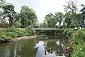
The Boundary Footbridge crosses Rock Creek at the Maryland–D.C. border
-
Rock Creek near its terminus at the Potomac River in Georgetown


