
Rock Port, Missouri facts for kids
Quick facts for kids
Rock Port, Missouri
|
|
|---|---|

Main Street between Clay and Cass streets
|
|

Location of Rock Port, Missouri
|
|
| Country | |
| State | |
| County | Atchison |
| Township | Clay |
| Area | |
| • Total | 2.77 sq mi (7.18 km2) |
| • Land | 2.77 sq mi (7.18 km2) |
| • Water | 0.00 sq mi (0.00 km2) |
| Elevation | 942 ft (287 m) |
| Population
(2020)
|
|
| • Total | 1,278 |
| • Estimate
(2020)
|
1,187 |
| • Density | 429.81/sq mi (165.95/km2) |
| Time zone | UTC-6 (Central (CST)) |
| • Summer (DST) | UTC-5 (CDT) |
| ZIP code |
64482
|
| Area code(s) | 660 |
| FIPS code | 29-62696 |
| GNIS feature ID | 0730197 |
| Website | rpmo.com |
Rock Port is a city in, and the county seat of, Atchison County, Missouri, United States. The population was 1,278 at the 2020 census.
Contents
History
Rock Port was laid out in 1851. The city, which is eight miles east of the Missouri River in the Loess Hills bluffs above the river, derives its name from Rock Creek, which flows through it. It was originally named Linden.
The original city is off the interstate, but an additional area is built that is a travel hub. Truck stops, motels, fast food and firework stands are located along the interstate hosting a large amount of day time visitors, despite the city's small size.
The city of Rock Port has become largely energy self-sufficient. In April 2008, Rock Port claimed to be the first community in the United States to have its electricity 100 percent generated by wind power. Rock Port, which uses about 13 million kWh a year, has its power generated by the Loess Hills Wind Farm. The farm has four Suzlon 1.25-megawatt wind turbines. Excess power is sold to the Missouri Public Utility Alliance in Columbia, Missouri. The idea for the wind turbines came from the town's former mortuary worker, Eric Chamberlain. The farm was built by Wind Capital Group and is by far the company's smallest wind farm developed through January 2009. Wind Capital in 2008 built the bigger 50.4MW Cow Branch Wind Farm between Rock Port and Tarkio.
The Atchison County Memorial Building and John Dickinson Dopf Mansion are listed on the National Register of Historic Places.
Geography
Rock Port is located at 40°24′44″N 95°31′11″W / 40.41222°N 95.51972°W (40.412268, -95.519792). According to the United States Census Bureau, the city has a total area of 2.77 square miles (7.17 km2), all land.
Demographics
| Historical population | |||
|---|---|---|---|
| Census | Pop. | %± | |
| 1860 | 305 | — | |
| 1870 | 490 | 60.7% | |
| 1880 | 715 | 45.9% | |
| 1890 | 934 | 30.6% | |
| 1900 | 1,080 | 15.6% | |
| 1910 | 1,053 | −2.5% | |
| 1920 | 1,136 | 7.9% | |
| 1930 | 1,162 | 2.3% | |
| 1940 | 1,406 | 21.0% | |
| 1950 | 1,511 | 7.5% | |
| 1960 | 1,310 | −13.3% | |
| 1970 | 1,575 | 20.2% | |
| 1980 | 1,511 | −4.1% | |
| 1990 | 1,438 | −4.8% | |
| 2000 | 1,395 | −3.0% | |
| 2010 | 1,318 | −5.5% | |
| 2019 (est.) | 1,191 | −9.6% | |
| U.S. Decennial Census | |||
2010 census
As of the census of 2010, there were 1,318 people, 588 households, and 356 families living in the city. The population density was 475.8 inhabitants per square mile (183.7/km2). There were 667 housing units at an average density of 240.8 per square mile (93.0/km2). The racial makeup of the city was 98.2% White, 0.3% Native American, 0.1% from other races, and 1.4% from two or more races. Hispanic or Latino of any race were 1.9% of the population.
There were 588 households, of which 26.9% had children under the age of 18 living with them, 46.8% were married couples living together, 9.7% had a female householder with no husband present, 4.1% had a male householder with no wife present, and 39.5% were non-families. 34.7% of all households were made up of individuals, and 16.2% had someone living alone who was 65 years of age or older. The average household size was 2.15 and the average family size was 2.75.
The median age in the city was 46.3 years. 21.4% of residents were under the age of 18; 6.9% were between the ages of 18 and 24; 19.8% were from 25 to 44; 28.8% were from 45 to 64; and 23.1% were 65 years of age or older. The gender makeup of the city was 47.7% male and 52.3% female.
Education
Public education in Rock Port is administered by Rock Port R-II School District.
Rock Port has a public library, the Atchison County Library.
Notable people
- Loraine Boettner, American Protestant theologian
- Michael J. Burg (born 1968), actor
- Hardin Cox (1928–2013), politician and businessman
Images for kids
-
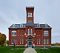
Atchison County courthouse in Rock Port

See also
 In Spanish: Rock Port (Misuri) para niños
