
Rockland County, New York facts for kids
Quick facts for kids
Rockland County
|
|||
|---|---|---|---|

View of the Hudson River looking southward from Hook Mountain State Park.
|
|||
|
|||

Location within the U.S. state of New York
|
|||
 New York's location within the U.S. |
|||
| Country | |||
| State | |||
| Founded | 1798 | ||
| Named for | its rocky terrain | ||
| Seat | New City | ||
| Largest CDP | New City | ||
| Area | |||
| • Total | 199.34 sq mi (516.3 km2) | ||
| • Land | 173.55 sq mi (449.5 km2) | ||
| • Water | 25.79 sq mi (66.8 km2) 13% | ||
| Population | |||
| • Estimate
(2020)
|
338,329 | ||
| • Density | 1,949.46/sq mi (752.69/km2) | ||
| Time zone | UTC−5 (Eastern) | ||
| • Summer (DST) | UTC−4 (EDT) | ||
| Area code | 845 | ||
| Congressional district | 17th | ||


Rockland County is the southernmost county on the west side of the Hudson River in the U.S. state of New York. It is part of the New York City metropolitan statistical area. It is about 6 miles (10 kilometers) from the Bronx at their closest points. The county's population, as of the 2020 United States Census, is 338,329, making it the third-most densely populated county outside New York City within New York (after Nassau and neighboring Westchester Counties, respectively). The county seat is New City. Rockland County is accessible via the New York State Thruway, which crosses the Hudson to Westchester at the Tappan Zee Bridge ten exits up from the NYC border, as well as the Palisades Parkway five exits up from the George Washington Bridge. The county's name derives from "rocky land", as the area has been aptly described, largely due to the Hudson River Palisades.
Rockland County is the smallest county by area in New York outside New York City. It comprises five towns and nineteen incorporated villages, with numerous unincorporated villages (sixteen) and hamlets. Rockland County is designated as a Preserve America Community, and nearly a third of the county's area is parkland. The county has the largest Jewish population percentage of any U.S. county, at 31.4%, or 90,000 residents. Rockland also ranked 31st on the list of highest-income counties by median household income in the United States, with a median household income of $82,534 according to the 2010 census.
Contents
History
On February 14, 2017 Edwin J. Day, County Executive of Rockland County proclaim February 14, 2017 as Rockland County Local History Day.


The area that would become Rockland County was originally inhabited by Algonquian-speaking Aboriginals, including Munsees, or Lenni Lenape.
In 1609, Henry Hudson, thinking he had found the legendary "Northwest Passage", sailed on the Half Moon up the river that would one day bear his name and anchored near the area that is now Haverstraw before continuing to disillusionment north of Albany. The Dutch were the first Europeans to settle in the area, around 1675. These settlers, eager to escape "city life", moved from Manhattan to Rockland. A number of unique Dutch-style red sandstone houses still stand, and many place names in the county reveal their Dutch origin. When the Duke of York (who became King James II of England) established the first twelve counties of New York in 1683, present-day Rockland County was part of Orange County known then as "Orange County South of the Mountains". Orangetown was created at the same time under a royal grant, originally encompassing all of modern Rockland County. Around this time, as the English began to colonize Nyack and Tappan, the Native Americans began to leave Rockland in search of undisturbed land further north.
The natural barrier of the Ramapo Mountains and the size of the county made it difficult to carry out governmental activities. At one point there were twin governments, one on each side of the Ramapo Mountains. For this reason, Rockland split off from Orange in 1798 to form its own county. That same year the county seat was transferred from Tappan to New City, where a new courthouse was built.
Haverstraw was separated from Orangetown in 1719 and became a town in 1788; it included the present-day Clarkstown, Ramapo and Stony Point. Clarkstown and Ramapo became towns in 1791, followed by Stony Point in 1865.

During the American Revolution, when control of the Hudson River was viewed by the British as strategic to dominating the American territories, Rockland saw skirmishes at Haverstraw, Nyack and Piermont, and significant military engagements at the Battle of Stony Point, where General "Mad" Anthony Wayne earned his nickname. George Washington had headquarters for a time at John Suffern's tavern, the later site of the village of Suffern. British Major John André met with American traitor Benedict Arnold near Stony Point to buy the plans for the fortifications at West Point. André was captured with the plans in Tarrytown on his way back to the British lines; he was brought to Tappan for trial in the Tappan church, found guilty, hanged and buried nearby. Still another important chapter in the story of the Revolution was written on May 5, 1783, when General Washington received Sir Guy Carleton at the DeWint House, where they discussed the terms of the peace treaty. Two days later Washington visited Sir Guy aboard a British war vessel. On this day the King's Navy fired its first salute to the flag of the United States of America.
In the decades following the Revolution, Rockland became popular for its stone and bricks. These products, however, required quarrying in land that many later believed should be set aside as a preserve. Many unsuccessful efforts were made to turn much of the Hudson Highlands on the northern tip of the county into a forest preserve. However, Union Pacific Railroad president E. H. Harriman donated land as well as large sums of money for the purchase of properties in the area of Bear Mountain. Bear Mountain/Harriman State Park became a reality in 1910, and by 1914 it was estimated that more than a million people a year were coming to the park.
Rockland remained semi-rural until the 1950s when the Palisades Interstate Parkway, Tappan Zee Bridge, and other major arteries were built. The idea of suburbia also helped transform the county. The county's population flourished, from 89,276 in 1950 to 265,475 in 1990.

Geography


According to the U.S. Census Bureau, the county has a total area of 199 square miles (520 km2), of which 174 square miles (450 km2) is land and 26 square miles (67 km2) (13%) is water. It is the smallest county in the state outside of New York City.
Rockland County lies just north of the New Jersey-New York border, west of Westchester County across the Hudson River, and south of Orange County.
The county's elevations range from 1,283 feet (391 m) atop Rockhouse Mountain to sea level along the Hudson River. Approximately 30% of Rockland County is devoted to parkland, belonging to either the five towns, incorporated villages, the state, or the county. These parks provide walking and hiking trails, ballfields, dog runs, historic sites, ponds, streams, salt marshes, and equestrian trails. Some popular state parks include Bear Mountain State Park on the northernmost tip of the county, Harriman State Park also along the county's northern boundary, and Nyack Beach State Park along the Hudson River, with trails connecting to Rockland Lake State Park. In addition to parks, Rockland is home to numerous public and private golf courses, with the towns of Orangetown, Ramapo, Stony Point, and Haverstraw all operating public golf courses within their towns, offering discounted rates to their respective residents. The Palisades Interstate Park Commission also operates two golf courses in Rockland Lake State Park with sweeping views of the park. Notable private courses in the county include Dellwood Country Club, Manhattan Woods Golf Course (designed by PGA great Gary Player), Minisceongo Golf Club (Ramapo), and Rockland Country Club (Sparkill).
Adjacent counties
- Orange County (northwest)
- Putnam County (northeast)
- Westchester County (east)
- Passaic County, New Jersey (west)
- Bergen County, New Jersey (south)
Rockland's borders with Putnam and Passaic counties are short, totaling less than one mile (1.6 km).
Demographics
| Historical population | |||
|---|---|---|---|
| Census | Pop. | %± | |
| 1800 | 6,353 | — | |
| 1810 | 7,758 | 22.1% | |
| 1820 | 8,837 | 13.9% | |
| 1830 | 9,388 | 6.2% | |
| 1840 | 11,975 | 27.6% | |
| 1850 | 16,962 | 41.6% | |
| 1860 | 22,492 | 32.6% | |
| 1870 | 25,213 | 12.1% | |
| 1880 | 27,690 | 9.8% | |
| 1890 | 35,162 | 27.0% | |
| 1900 | 38,298 | 8.9% | |
| 1910 | 46,873 | 22.4% | |
| 1920 | 45,548 | −2.8% | |
| 1930 | 59,599 | 30.8% | |
| 1940 | 74,261 | 24.6% | |
| 1950 | 89,276 | 20.2% | |
| 1960 | 136,803 | 53.2% | |
| 1970 | 229,903 | 68.1% | |
| 1980 | 259,530 | 12.9% | |
| 1990 | 265,475 | 2.3% | |
| 2000 | 286,753 | 8.0% | |
| 2010 | 311,687 | 8.7% | |
| 2020 | 338,329 | 8.5% | |
| US Decennial Census 1790-1960 1900-1990 1990-2000 2010, 2019 |
|||
2020 census
As of the 2020 United States Census., 338,329 people and 100,438 households were residing in the county. The population density was 1,950/sq mi (753/km2). The 107,002 housing units averaged 617/sq mi (238/km2).
| Rockland County Demographics | |
|---|---|
| Racial demographics of Rockland according to 2020 US Census Bureau data: | |
| Race | Percentage |
| White (Whites of non-Hispanic origin: 62.7%) | 77.9% |
| Hispanics and Latinos (of any race) | 18.4% |
| Black | 13.1% |
| Asian | 6.2% |
| Multiracial | 2.1% |
| American Indian and Alaska Native persons | 0.6% |
| Native Hawaiian and Other Pacific Islander persons | 0.1% |
Of the 107,002 households, 38% had children under the age of 18 living with them, 63% were married couples living together, 10% had a female householder with no husband present, and 23% were not families. Around 19% of households were made up of individuals, and 8% had someone living alone who was 65 or older. The average household size was 3.0 and the average family size was 3.5.
The county's age distribution was 28.4% under 18, 8% from 18 to 24, 28% from 25 to 44, 24.30% from 45 to 64, and 12% who were 65 or older. The median age was 36 years. For every 100 women, there were 95 men. For every 100 women age 18 and over, there were 91 men.
The median income for a household was $93,024 and for a family was $80,000. Males had a median income of $58,000 versus $39,000 for females. The per capita income for the county was $39,286. The mean, or average, income for a family in Rockland County is $73,500 according to the 2004 census. About 6% of families and 12.5% of the population were below the poverty line, including 14% of those under age 18 and 8% of those age 65 or over.
Transportation

The Tappan Zee Bridge connects South Nyack in Rockland County and Tarrytown in Westchester County across the Hudson River in the Lower Hudson Valley of New York. The old bridge was replaced with a new span in 2017.
Major highways
The county is served by several major highways, including Interstate 87/287 (the New York Thruway), opening from Suffern to Yonkers in 1955. The old Tappan Zee Bridge opened the same year, connecting Rockland and Westchester, allowing Rockland County's population to grow rapidly. The Palisades Interstate Parkway, a project of master planner Robert Moses, and built between 1947 and 1958, connects the county directly to the George Washington Bridge due south. The Garden State Parkway opened in 1955, connecting New Jersey to I-87/287.
 I-87
I-87 I-287
I-287 US 6
US 6 US 9W
US 9W US 202
 Garden State Parkway
 Palisades Parkway
 NY 17
NY 17 NY 45
NY 45 NY 59 - Originated as the Nyack Turnpike
- Korean War Veterans Memorial Highway
 NY 210
 NY 303
 NY 304
- "Rockland County Clerk Paul Piperato Memorial Highway"
 NY 306
 NY 340
For further information
- List of county routes in Rockland County, New York
- List of county routes in Rockland County, New York (1–38)
- List of county routes in Rockland County, New York (41–75)
- List of county routes in Rockland County, New York (76–118A)
Bus

The Transport of Rockland operates several local bus routes throughout the county, and the express bus Hudson Link routes to city centers and train stations in Tarrytown and White Plains in Westchester County. TOR provides connections to other neighborhood bus operations – Minitrans and connections to private commuter lines, Rockland Coaches and Short Line providing service to northern New Jersey and New York City.
Railroad
NJ Transit/Metro-North Railroad operates the Port Jervis Line, which stops at the Suffern Railroad Station and Sloatsburg Station, and the Pascack Valley Line, whose stops include Pearl River, Nanuet, and Spring Valley. in their respective hamlets and village of the same name. Connections on this line are available at Secaucus for service to Penn Station in Midtown Manhattan and service to the Meadowlands Sports Complex in East Rutherford, New Jersey. The southern terminus of both lines is Hoboken Terminal in New Jersey, where connections can be made to several NJ Transit bus lines, ferries, and PATH trains to New York City.
Until 1958, Rockland County's eastern side was served by the New York Central Railroad's passenger service on the West Shore Railroad from Weehawken, New Jersey, opposite midtown Manhattan up through Tappan, West Nyack, Congers, and Haverstraw, on to the West Hudson shore cities of Newburgh, Kingston, and Albany. The service ran to West Haverstraw, in the north of the until 1959. The Erie Railroad ran train service on the Northern Branch through the southeastern corner of the county to Nyack up to 1966.
Ferry
NY Waterway operates a ferry service between Haverstraw and Ossining in Westchester County for the Metropolitan Transportation Authority. Commuters take the Transport of Rockland's Ferry Express route to the Haverstraw ferry terminal for service to Metro-North's Hudson Line service to Grand Central Terminal. Ferry service is typically suspended in the colder months when the Hudson River freezes over, and commuters must take shuttle buses across the Tappan Zee Bridge.
Airports
Nearby airports include:
- New York: John F. Kennedy International Airport, LaGuardia Airport, Westchester County Airport, and Stewart International Airport
- New Jersey: Newark Liberty International Airport, Teterboro Airport
Solar field
Clarkstown is building a first-of-its-kind in New York State, a 2.3-megawatt solar system consisting of about 4,300 panels on top of a closed, highly regulated, flat shadeless 13-acre section of the former garbage landfill in West Nyack which will generate 3 million kilowatt-hours – enough power to supply about 200 homes, that will cover about one-third of the electric needs of the Town of Clarkstown government. The Clarkstown solar field project is at the maximum size that is currently allowed by New York State. Of the 1,200 installations in Orange and Rockland system, 450, or 32 percent, are in Rockland County and will save taxpayers as much as $4 million over 30 years by reducing the amount of the town’s annual electric bill – which is about $2 million and produce 10 percent of all the electricity that O&R gets through solar power. This project was scheduled to be on line by the fall of 2014.
Municipalities

Paul W. Adler, the chairperson of the Rockland County's Jewish Community Relations Council, said in a 1997 New York Times article that "There are two reasons villages get formed in Rockland. One is to keep the Hasidim out and the other is to keep the Hasidim in."
There are five towns in Rockland County. The most populous is Ramapo, with 126,595 people, while the least populous is Stony Point, with 15,059 people, according to the 2010 US Census.
In 2015, ValuePenguin ranked the Towns of Clarkstown(119), Haverstraw(102), Orangetown(72), Ramapo(55) and Stony Point(52) as the Safest Places in New York with population of over 5,000 and other criteria. The villages of Spring Valley (169) and Suffern (42) also made the list. Ramapo ranked 7th place among big cities - population of over 20 thousand.
There are nineteen incorporated villages in Rockland County, twelve of which are located at least partially in the town of Ramapo, and none of which are in Stony Point. There are seventeen Census-designated places and seven Hamlets within the five towns of Rockland County.
Towns (5)
Villages (19)
Census-designated places (17)
Hamlets (7)
Defunct Communities (10)
Points of interest
Educational and cultural
- Major John Andre Monument - Tappan, New York. Honors the great British army officer John André, well known for assisting Benedict Arnold in his attempted surrender in West Point during the American Revolutionary War
- Camp Shanks - Orangetown, New York. A museum that was once a military camp. It is named after Major General David Carey Shanks (1861–1940).
- Edward Hopper Birthplace and Boyhood Home- Nyack, New York. This was the home of American realism painter Edward Hopper. It is now an art center.
- Washington Avenue Soldier's Monument and Triangle - Suffern, New York. This is a memorial honoring George Washington and Rochambeau, where they encamped at the site of the memorial during the American Revolutionary War.
- The Old 76 House- Tappan, New York. One of the oldest bars in America. It was originally a meeting place for Patriots during the Revolutionary War. The house was the headquarters of Nathaniel Greene.
Commercial and entertainment
- Palisades Center - West Nyack, New York. Opened in 1998, it is one of America's largest shopping malls.
- The Shops at Nanuet - Nanuet, New York. Opened in 1969, it was formerly named the Nanuet Mall. It was the site of the notorious 1981 Brinks Robbery.
- Palisades Credit Union Park - Ramapo, New York. A baseball stadium home to the Rockland Boulders and the St. Thomas Aquinas College baseball team.
- Lafayette Theatre - Suffern, New York. A movie palace located in the downtown area of Suffern, New York.
- Blue Hill Plaza - Pearl River, New York. 21-story office tower and an eight-story office building on 90-acres of landscaped and wooded property.
Parks
- Bear Mountain State Park - Stony Point, New York
- Blauvelt State Park - Blauvelt, New York
- Harriman State Park (bordered between Rockland and Orange County, New York)
- High Tor State Park - Clarkstown, New York
- Nyack Beach State Park - Upper Nyack, New York
- Rockland Lake State Park - Congers, New York
- Tallman Mountain State Park - Orangetown, New York
Sports

- The New York Boulders (formerly the Rockland Boulders), a member of the Frontier League, was founded in 2011 by former Yankee catcher John Flaherty of Pearl River, Clarkstown resident Michael Aglialoro (president of Clarkstown Education Foundation) and Stephen Mulvey (former part-owner of the Brooklyn-Los Angeles Dodgers). The team, owned by Bottom 9 Baseball, play their home games at the 6,362-seat, 16-suite Clover Stadium.
- Rockland Country Club is located in Sparkill, New York and features an 18-hole golf course.
- The New York Raiders, an American semi-professional rugby league football team based in Congers, New York, currently play in the American National Rugby League (AMNRL) competition. Their home games are at Rockland Lake State Park; they partner with the Canberra Raiders of Australia's National Rugby League (NRL).
- The Nyack Rocklands played minor league baseball in the North Atlantic League from 1946 to 1948. The Rocklands were an affiliate of the Philadelphia Athletics.
Education

The county is home to several Blue Ribbon School of Excellence Award winners, awarded by the U.S. Department of Education:
- In 2000–2001, Liberty Elementary School in Valley Cottage (semi-finalists in 2004)
- In 2007, Strawtown Elementary School in West Nyack
- In 2008 & 2014, Franklin Avenue Elementary School in Pearl River
- In 2009, George W. Miller Elementary School in Nanuet
- In 2011, Pearl River Middle School in Pearl River
- In 2013, Cherry Lane Elementary School in Suffern
- In 2016, Nanuet Senior High School In Nanuet
- In 2018, Clarkstown High School South
School districts
- Clarkstown Central School District
- East Ramapo Central School District
- Nanuet Union Free School District
- North Rockland Central School District
- Nyack Public Schools
- Pearl River School District
- Suffern Central School District
- South Orangetown Central School District
High schools
Colleges and universities
The county is home to several colleges and universities. - State University of New York (SUNY): - Rockland Community College - Suffern, NY
- Beth Medrash Elyon
- Dominican College (Dominican College of Blauvelt) - Orangeburg
- Long Island University extension site at Rockland Community College - Suffern
- Columbia University's Lamont–Doherty Earth Observatory
- Nyack College - Nyack
- Rabbinical College Beth Shraga - Monsey, NY
- St. Thomas Aquinas College - Sparkill, NY
- Yeshiva D'Monsey Rabbinical College - Monsey
- Yeshivath Viznitz - Kaser (Monsey)
Images for kids
-
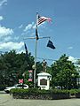
Washington Avenue Soldier's Monument in Ramapo

See also
 In Spanish: Condado de Rockland para niños
