
Rome, Georgia facts for kids
Quick facts for kids
Rome, Georgia
|
|
|---|---|
|
City
|
|
| City of Rome | |

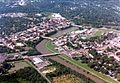
View of Rome from Myrtle Hill Cemetery
|
|

Location in Floyd County and the state of Georgia
|
|

Rome, Georgia
Location in Georgia (U.S. state)

Rome, Georgia
Location in the United States
|
|
| Country | |
| State | |
| County | Floyd |
| Incorporated | December 20, 1834 |
| Named for | Rome, Italy |
| Government | |
| • Type | Commission–manager |
| Area | |
| • City | 32.45 sq mi (84.05 km2) |
| • Land | 31.68 sq mi (82.05 km2) |
| • Water | 0.77 sq mi (1.99 km2) |
| Elevation | 614 ft (187 m) |
| Population
(2020)
|
|
| • City | 37,713 |
| • Density | 1,190.40/sq mi (459.61/km2) |
| • Metro | 96,317 |
| • Demonym | Roman |
| Time zone | UTC−5 (EST) |
| • Summer (DST) | UTC−4 (EDT) |
| ZIP code |
30149, 30161, 30165
|
| Area code(s) | 706 and 762 |
| FIPS code | 13-66668 |
| GNIS feature ID | 0356504 |
| Major airport | CHA |
Rome is the largest city in and the county seat of Floyd County, Georgia, United States. Located in the foothills of the Appalachian Mountains, it is the principal city of the Rome, Georgia, metropolitan statistical area, which encompasses all of Floyd County. At the 2020 census, the city had a population of 37,713. It is the largest city in Northwest Georgia and the 22nd-largest city in the state.
Rome was founded in 1834, after Congress passed the Indian Removal Act, and the federal government committed to removing the Cherokee and other Native Americans from the Southeast. It developed on former indigenous territory at the confluence of the Etowah and the Oostanaula rivers, which together form the Coosa River. Because of its strategic advantages, this area was long occupied by the historic Creek. Later the Cherokee people expanded into this area from their traditional homelands to the east and northeast. National leaders such as Major Ridge and John Ross resided here before Indian Removal in 1838.
The city has developed on seven hills with the rivers running between them, a feature that inspired the early European-American settlers to name it for Rome, the longtime capital of Italy that was also built on seven hills. The American Rome developed in the antebellum period as a market and trading city due to its advantageous location on the rivers. It shipped the rich regional cotton commodity crop downriver to markets on the Gulf Coast and export overseas.
In the late 1920s, a United States company built a rayon plant in a joint project with an Italian company. This project and the American city of Rome were honored by Italy in 1929, when its duce Benito Mussolini sent a replica of the statue of Romulus and Remus nursing from a mother wolf, a symbol of the founding myth of the original Rome.
It is the largest city near the center of the triangular area defined by the Interstate highways between Atlanta, Birmingham, and Chattanooga. It has developed as a regional center for the fields of medical care and education. In addition to its public-school system, it has several private schools. Higher-level institutions include private Berry College and Shorter University, and the public Georgia Northwestern Technical College and Georgia Highlands College.
Contents
Geography


Rome is located at the confluence of the Etowah and the Oostanaula rivers, whose merging forms the Coosa River. This gave it access to the waterways, the major transportation routes of the era. Because of this water feature, Rome developed as a regional trade center, based originally on King Cotton. As cotton plantations were developed in the area, Rome was an increasingly important market town, shipping the commodity downriver to other markets. It was designated as the county seat of Floyd County.
According to the United States Census Bureau, the city has a total area of 31.6 square miles (81.9 km2), of which 30.9 square miles (80.1 km2) is land and 0.73 square miles (1.9 km2), or 2.29%, is water.
The seven hills that inspired the name of Rome are known as Blossom, Jackson, Lumpkin, Mount Aventine, Myrtle, Old Shorter, and Neely hills. (The latter is also known as Tower or Clock Tower Hill). Some of the hills have been partially graded since Rome was founded.
History
Native American era
People of the Mississippian culture are known to have inhabited the area from about 1000 CE. These people are believed to have died off from disease brought by exposure to the Spaniards in the late 16th century. The Cherokee migrated into the Southeast and established themselves in the early 17th century.
Specifics before the Spanish expeditions in the 16th century are largely unknown, but archeologists have found evidence of thousands of years of indigenous cultures along these rivers.

There is some debate over whether Hernando de Soto was the first Spanish conquistador to encounter Native Americans in the area now known as Rome, but it is usually agreed that he passed through the region with his expedition in 1540. In 1560, Tristán de Luna sent a detachment of 140 soldiers and two Dominican friars north along de Soto's route. They established relations with the Coosa chiefdom, as they recorded assisting the Coosa in a raid against the rebellious province of Napochín, in what is now known as Tennessee. Exposed to new Eurasian infectious diseases, these mound builder peoples suffered high mortality rates, as they lacked immunity; within 20 years the community was abandoned.
The Creek emerged in the area, one of the major Muscogee-speaking tribes. They occupied a broad territory before being pushed out by Cherokee migrating from Tennessee.
The Abihka tribe of Creek in the area of Rome later became part of the Upper Creek people. They merged with other Creek tribes to become the Ulibahalis, who later migrated westward into Alabama in the general region of Gadsden. By the mid-18th century, Iroquoian-speaking Cherokee had moved into the area and occupied it. They had moved down from areas of Tennessee, under pressure from settlement by European Americans migrating from eastern territories across the Appalachians.

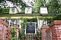
A Cherokee village named Chatuga was settled in this area during the late eighteenth century, in the period of the Cherokee–American wars (1776–94) during and after the American Revolutionary War. The Cherokee referred to this area as "Head of Coosa". Several Cherokee national leaders settled here, developing plantations, including chiefs Major Ridge and John Ross. In the 20th century, Ridge's home here was preserved as Chieftains House. It has been adapted by the state for use as the Chieftains Museum and is used to represent the history of the Cherokee in this area, especially Major Ridge.
In the 18th century, a high demand in Europe for American deer skins had led to a brisk trade between Native hunters and white traders. A few white traders and some settlers (primarily from the British colonies of Georgia and Carolina) were accepted by the Head of Coosa Cherokee. These were later joined by missionaries, and then more settlers. After the American War of Independence, most new settlers came from the area of Georgia east of the Proclamation Line of 1763.

In 1793, in response to a Cherokee raid into Tennessee, John Sevier, the Governor of Tennessee, led a retaliatory raid against the Cherokee in the vicinity of Myrtle Hill, in what was known as the Battle of Hightower.
In 1802, the United States and Georgia executed the Compact of 1802, in which Georgia sold its claimed Western lands (a claim dating to the colonial era) to the United States. In return, the federal government agreed to ignore Cherokee land titles and remove all Cherokee from Georgia. The commitment to evict the Cherokee was not immediately enforced, and Chiefs John Ross and Major Ridge led efforts to stop their removal, including several Federal lawsuits.
During the 1813 Creek Civil War, most Cherokee took the side of the Upper Creek Indians, who were more assimilated and willing to deal with European Americans, against the Red Stick or Lower Creek Indians, who lived more distant from the whites and maintained strong cultural traditions. Before the Cherokee moved to Head of Coosa, Chief Ridge commanded a company of warriors as a unit of the Tennessee militia, with Chief Ross as adjutant. This Cherokee unit was under the overall command of United States Major Andrew Jackson, and supported the Upper Creek. They were the part of the Creek who had adopted more European-American customs and were more aligned with American settlers. The Red Stick Creek lived in a more geographically removed area and held more closely to traditional Creek life. The Creek War played out within the US-British conflict of the War of 1812.

In 1829, European Americans discovered gold near Dahlonega, Georgia, starting the first gold rush in the United States. Congressional passage of the Indian Removal Act of 1830, which fulfilled the Compact of 1802, was related to that gold discovery and the desire of whites to settle the land, as well as President Andrew Jackson's commitment to removal.
Even before removal began, in 1831 Georgia's General Assembly passed legislation that claimed all Cherokee land in Northwest Georgia. This entire territory was called Cherokee County; the following year the Assembly organized the territory as the nine counties that still exist in the 21st century.
City founding period
Rome was founded in 1834 as European Americans increasingly settled in Georgia. Founders were Col. Daniel R. Mitchell, Col. Zacharia Hargrove, Maj. Philip Hemphill, Col. William Smith, and John Lumpkin (nephew of Governor Lumpkin); most were veterans of the War of 1812. They held a drawing to determine the name of the new city, with Col. Mitchell submitting the name of Rome because of the area's hills and rivers. Mitchell's submission was drawn, and the Georgia Legislature chartered Rome as an official city in 1835. The county seat was subsequently moved east from the village of Livingston to Rome.
With the entire area still occupied primarily by Cherokee, the city developed to serve the agrarian needs of the new cotton-based economy. Invention of the cotton gin in the late eighteenth century made processing of short-staple cotton profitable. This was the type of cotton that best thrived in the upland areas, in contrast to that grown on the Sea Islands and in the Low Country.
Much of upland Georgia was developed as what became known as the Black Belt, named for the fertile soil. Planters brought or purchased many enslaved African Americans as workers for the labor-intensive crop. The leading Cherokee participated in the cultivation of cotton as a commodity crop, which soon replaced deer-skin trading as a source of wealth in the region. The first steamboat navigated the Coosa River to Rome in 1836, reducing the time-to-market for the cotton trade and speeding travel between Rome and New Orleans on the Gulf Coast, the major port for export of cotton.
By 1838, the Cherokee had run out of legal options in resisting removal. They were the last of the major Southeast tribes to be forcibly moved to the Indian Territories (in modern-day Oklahoma) on the Trail of Tears. After the removal of the Cherokee, their homes and businesses were taken over by whites, with much of the property distributed through a land lottery.
The Rome economy continued to grow. In 1849, an 18-mile (29 km) rail spur to the Western and Atlantic Railroad in Kingston was completed, significantly improving transportation to the east. This route was later followed in the 20th-century construction of Georgia Highway 293. By 1860 the population had reached 4,010 in the city, and 15,195 in the county.
Civil war period

Rome's iron works were an important manufacturing center during the Civil War, supplying many cannons and other armaments to the Confederate effort. In April 1863 the city was defended by Confederate General Nathan Bedford Forrest against Union Colonel Abel Streight's "lightning mule" raid from the area east of modern-day Cedar Bluff, Alabama. General Forrest tricked Colonel Streight into surrendering just a few miles shy of Rome. Realizing their vulnerability, Rome's city council had allocated $3,000 to build three fortifications. Although these became operational by October 1863, efforts to strengthen the forts continued as the war progressed. These forts were named after Romans who had been killed in action: Fort Attaway was on the western bank of the Oostanaula River, Fort Norton was on the eastern bank of the Oostanaula, and Fort Stovall was on the southern bank of the Etowah River. The Confederates later built at least one other fort on the northern side of the Coosa River.


In May 1864, Union General Jefferson C. Davis, under the command of Major General William Tecumseh Sherman, attacked and captured Rome when the outflanked Confederate defenders retreated under command of Major General Samuel Gibbs French. Union General William Vandever was stationed in Rome and is shown with his staff in a photograph taken there. Due to Rome's forts and iron works, which included the manufacture of cannons, Rome was a significant target during Sherman's march through Georgia to take and destroy Confederate resources. Davis' forces occupied Rome for several months, making repairs to use the damaged forts and briefly quartering General Sherman. Foreshadowing Sherman's Special Field Orders, No. 120, Union forces destroyed Rome's forts, iron works, the rail line to Kingston, and any other material that could be useful to the South's war effort as they withdrew from Rome to participate in the Atlanta Campaign.
Reconstruction era and 19th century

In 1871, Rome constructed a water tank on Neely Hill, which overlooks the downtown district. This later was adapted as a clock tower visible from many points in the city. It has served as the town's iconic landmark ever since, and is featured in the city's crest and local business logos. As a result, Neely Hill is also referred to as Tower or Clock Tower Hill. In this period the city established its first public schools, authorized by the state legislature in 1868 for the first time for all children, with some designated funding. Schools were segregated and tended to have short sessions limited by funding. Freedmen had the power to vote under new amendments to the US Constitution, affecting local politics. The abolition of slavery required new labor arrangements.
Due to its riverside location, Rome has occasionally suffered serious flooding. The flood of 1886 inundated the city to such depth that a steamboat traveled down Broad Street. In 1891, upon recommendation of the United States Army Corps of Engineers, the Georgia State Legislature amended Rome's charter to create a commission to oversee the construction of river levees to protect the town against future floods. In the late 1890s, additional flood control measures were instituted, including raising the height of Broad Street by about 15 feet (4.6 m). As a result, the original entrances and ground-level floors of many of Rome's historic buildings became covered over and had to serve as basements.
Twentieth century

In the early 20th century, the Georgia Assembly approved a charter for the city to establish a commission-manager form of government, a reform idea to add a management professional to the team.

In 1928, the American Chatillon Company began construction of a rayon plant in Rome; it was a joint business effort with the Italian Chatillon Corporation. Italian premier Benito Mussolini sent a block of marble from the ancient Roman Forum, inscribed "From Old Rome to New Rome", to be used as the cornerstone of the new rayon plant. After the rayon plant was completed in 1929, Mussolini honored the American Rome with a bronze replica of the sculpture of Romulus and Remus nursing from the Capitoline Wolf. The statue was placed in front of City Hall on a base of white marble from Tate, Georgia, with a brass plaque inscribed:
"This statue of the Capitoline Wolf, as a forecast of prosperity and glory, has been sent from Ancient Rome to New Rome during the consulship of Benito Mussolini in the year 1929."
In 1940, anti-Italian sentiment due to World War II became so strong that the Rome city commission moved the statue into storage to prevent vandalism. They replaced it with an American flag. In 1952, the city restored the statue to its former location in front of City Hall.
Great Depression
In Rome, the effect of the Great Depression was significantly less severe than in other, larger cities across the United States. Since Rome was an agricultural town, food could be grown in surrounding areas. Rome's textile mill continued operating, providing steady jobs as a buffer against the hardships of the Great Depression.
The Great Depression was preceded by the "Cotton Bust" across the South. This reached Rome in the mid-1920s, and caused many farmers to move away, sell their land or convert to other agricultural crops, such as corn. Farm workers were displaced, and many African Americans left the area in the Great Migration, seeking work in cities, including those in the North and Midwest. Cotton crops were being destroyed by the boll weevil, a tiny bug that reached Georgia in 1915 (invading from Louisiana). The boll weevil destroyed many fields of cotton and put a damper on Rome's economy.
While the Rome area was not as devastated as many big cities during the Depression, many families struggled through hard financial times. Jobs were scarce, and prices of food and basic commodities went up. The federal "postal employees took a fifteen per cent cut in pay, and volunteered a further ten per cent reduction in work time in order to save the jobs of substitute employees who otherwise would have been thrown out of work." Among fundraising activities for the poor, wealthier residents bought tickets to a show put on by local performers; the fares were paid to grocers, who made boxes of food to sell at a discount price to needy families.
In a private "works project" to provide employment to men out of work, S.H. Smith, Sr. decided to replace the Armstrong Hotel. After demolishing it, he employed many people to help build the towering Greystone Hotel at the corner of Broad Street and East Second Street. The Rome News-Tribune reported on November 30, 1933, an increase in local building permits for a total of $95,800; of this amount, $85,000 was invested by S.H. Smith, Sr., in the construction of the Greystone Hotel. He added the Greystone Apartments in 1936.
Arts and culture

- Martha Berry Museum, honoring a founder of Berry College
- Rome Area History Museum
- Chieftains Museum (Major Ridge Home), a museum of Cherokee history, honoring chief Major Ridge and other leaders
- Clock Tower, a clock tower museum
- Rome Braves, a Class A affiliate of the Atlanta Braves
Sites on the National Register of Historic Places
Rome has many historic homes and businesses, some of which are listed on the National Register of Historic Places:
| Site | Year built |
Address | Year registered |
|---|---|---|---|
| Dr. Robert Battey House | 1850 | 725 East 2nd Ave. | 1982 |
| Berry Schools | North of Rome on U.S. Hwy 27 | 1978 | |
| Between the Rivers Historic District | Roughly bounded by the Etowah and Oostanaula rivers, 7th Ave., and West 4th St. | 1983 Ext. 1989 |
|
| Chieftains | 1792 | 501 Riverside Parkway. | 1971 |
| Double-Cola Bottling Company | 419 East Second Ave. | 2006 | |
| East Rome Historic District | Roughly bounded by Walnut Ave., McCall Blvd., East 8th and 10th Sts. | 1985 | |
| Etowah Indian Mounds | North bank of Etowah River | 1966 | |
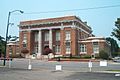
| Floyd County Courthouse | 5th Ave. and Tribune St. | 1980 | |
| Jackson Hill Historic District | Jackson Hill, between GA Hwy 53 and the Oostanaula River | 1997 | |
| Joseph Ford House | Address Restricted | 1980 | |
| Lower Avenue A Historic District | Avenue A between North 5th St. and Turner-McCall Blvd. | 1983 | |
| Main High School | 41 Washington Dr. | 2002 | |
| Mayo's Bar Lock and Dam | On the Coosa River, 8 miles SW of Rome | 1989 | |
| Mt. Aventine Historic District | Address restricted | 1983 | |
| Myrtle Hill Cemetery | 1857 | Bounded by S. Broad, and Myrtle Sts., Pennington, and Branham Aves. | 1983 |
| Oakdene Place | Roughly bounded by the Etowah River, Queen, and East 6th Sts. | 1983 | |
| Rome Clock Tower | 1871 | Corner of East 2nd Street and East 5th Avenue | 1980 |
| South Broad Street Historic District | South Broad St. and Etowah Terrace | 1983 | |
| Sullivan—Hillyer House | 309 East 2nd Ave. | 2002 | |
| Thankful Baptist Church | 935 Spiderwebb Dr. | 1985 | |
| U.S. Post Office and Courthouse | West 4th Ave. and East 1st St. | 1975 | |
| Upper Avenue A Historic District | Roughly bounded by Oostanaula River, Turner-McCall Blvd., Avenue B and W. 11th St. | 1983 |
Demographics
| Historical population | |||
|---|---|---|---|
| Census | Pop. | %± | |
| 1860 | 4,010 | — | |
| 1870 | 2,748 | −31.5% | |
| 1880 | 3,877 | 41.1% | |
| 1890 | 6,957 | 79.4% | |
| 1900 | 7,291 | 4.8% | |
| 1910 | 12,099 | 65.9% | |
| 1920 | 13,252 | 9.5% | |
| 1930 | 21,843 | 64.8% | |
| 1940 | 26,282 | 20.3% | |
| 1950 | 29,615 | 12.7% | |
| 1960 | 32,336 | 9.2% | |
| 1970 | 30,759 | −4.9% | |
| 1980 | 29,654 | −3.6% | |
| 1990 | 30,326 | 2.3% | |
| 2000 | 34,980 | 15.3% | |
| 2010 | 36,303 | 3.8% | |
| 2020 | 37,713 | 3.9% | |
| U.S. Decennial Census | |||
2020 census
| Race | Num. | Perc. |
|---|---|---|
| White (non-Hispanic) | 17,971 | 47.65% |
| Black or African American (non-Hispanic) | 10,020 | 26.57% |
| Native American | 77 | 0.2% |
| Asian | 742 | 1.97% |
| Pacific Islander | 10 | 0.03% |
| Other/Mixed | 1,474 | 3.91% |
| Hispanic or Latino | 7,419 | 19.67% |
As of the 2020 United States census, there were 37,713 people, 14,169 households, and 8,870 families residing in the city.
Climate
The climate in this area is characterized by relatively high temperatures and evenly distributed precipitation throughout the year. According to the Köppen Climate Classification system, Rome has a humid subtropical climate, abbreviated "Cfa" on climate maps.
| Climate data for Rome, Georgia | |||||||||||||
|---|---|---|---|---|---|---|---|---|---|---|---|---|---|
| Month | Jan | Feb | Mar | Apr | May | Jun | Jul | Aug | Sep | Oct | Nov | Dec | Year |
| Average high °C (°F) | 53 (12) |
58 (14) |
62 (17) |
74 (23) |
82 (28) |
89 (32) |
91 (33) |
91 (33) |
85 (29) |
74 (23) |
62 (17) |
53 (12) |
73 (23) |
| Average low °C (°F) | 31 (−1) |
34 (1) |
38 (3) |
46 (8) |
55 (13) |
63 (17) |
67 (19) |
66 (19) |
60 (16) |
47 (8) |
35 (2) |
31 (−1) |
48 (9) |
| Average precipitation mm (inches) | 4.9 (120) |
5.3 (130) |
5.8 (150) |
4.3 (110) |
4 (100) |
3.8 (97) |
4.9 (120) |
3.1 (79) |
4.2 (110) |
2.8 (71) |
3.2 (81) |
5.4 (140) |
51.4 (1,310) |
| Source: Weatherbase | |||||||||||||
twin sister towns
Rome was a twins with Carrick on Shannon, Ireland since 1967
Gallery
-
Aerial view of downtown Rome, circa 1989
-
Downtown Rome, with the courthouse in the background
-
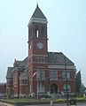
Historic Floyd County Courthouse
-
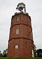
Historic Clock Tower on Neely Hill
-
The Rome Area History Museum
-
Rome City Hall and Auditorium. The statue of Romulus and Remus nursing from the Capitoline Wolf stands in front of the building.
-
This house, built in 1892, at 315 East Fourth Street was destroyed by a falling tree in April 2011.
-
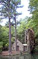
The waterwheel of the Berry Schools' Old Mill
-
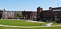
Rome Town Green
-
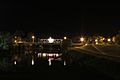
Heritage Park Bridge at Night
-
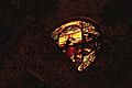
Stained Glass at St. Peter's Episcopal Church


- Roger Aycock, All Roads to Rome, Georgia: W. H. Wolfe Associates, 1981. Amazon.com
- George Magruder Battey Jr., A History of Rome and Floyd County, Georgia 1540-1922, Georgia: Cherokee Publishing Company, 2000. Amazon.com
- Morrell Johnson Darko, The Rivers Meet: A History of African-Americans in Rome, Georgia, Darko, 2003. Amazon.com
- Jerry R. Desmond, Georgia's Rome: A Brief History, Charleston: The History Press, 2008. Amazon.com
- Sesquicentennial Committee of the City of Rome, Rome and Floyd County: An Illustrated History, The Delmar Co 1986.Amazon.com
- Orlena M. Warner, When in Rome..., Georgia: Steven Warner, 1972. A collection of poems. Amazon.com
Economy
Rome has long had the strength of economic diversity, with an economy founded in manufacturing, education, healthcare, technology, tourism, and other industries. In 1954, General Electric established a factory to build medium transformers. In the 1960s, Rome contributed to the American effort in the Vietnam War when the Rome Plow Company produced Rome plows, large armored vehicles used by the U.S. military to clear jungles. In the latter part of the 20th century, many carpet mills prospered in the areas surrounding Rome.
Rome is also well known in the region for its medical facilities, particularly Floyd Medical Center, Redmond Regional Medical Center, and Harbin Clinic. Partnering with these facilities for physician development and medical education is the Northwest Georgia Clinical Campus of the Medical College of Georgia, which is part of Georgia Health Sciences University.
National companies that are part of Rome's technology industry include Brugg Cable and Telecom, Suzuki Manufacturing of America, automobile parts makers Neaton Rome and F&P Georgia, Peach State Labs, and the North American headquarters of Pirelli Tire. Other major companies in Rome include State Mutual Insurance Company.
In March 2020, Kerry Group announced plans to build a food-manufacturing facility in Rome at a cost of $125 million, the company's largest ever capital investment.
Sports
Since 2003, Rome has been the home of the Rome Braves, the High-A affiliate of the Atlanta Braves. The Rome Braves compete in the High-A East. According to numbers released in 2010, sports tourism is a major industry in Rome and Floyd County. In 2010, sport events netted over $10 million to the local economy, as reported by the Greater Rome Convention and Visitors Bureau. Of these, tennis tournaments accounted for over $6 million to the Rome economy in 2010.
Rome hosted the NAIA Football National Championship from 2008 until 2013.
Rome has hosted stages of the Tour de Georgia in 2003, 2004, 2005, 2006, and 2007.
The Georgia Fire was an indoor football team that played in Rome as a member of the Professional Indoor Football League.
Education
Rome City School District
The Rome City School District holds grades preschool to grade 12, operating seven elementary schools,North Heights shutting down in 2019/2020 Rome Middle School, and Rome High School. The district has 323 full-time teachers and more than 5,395 students.
Private schools
Rome has several private schools:
- Darlington School is a coeducational, college-preparatory day and boarding school established in 1905. It offers classes ranging from prekindergarten to grade 12, divided into lower, middle, and upper schools.
- Unity Christian School is a private, Christian school established in 1998. It offers classes ranging from prekindergarten to grade 12 with two classes per grade level.
- Berry College Elementary and Middle School offers the resources and expertise of a liberal-arts college faculty.
- Providence Preparatory Academy offers kindergarten through the grade 11, as of 2015, and plans to complete adding grades to the 12th year.
- St. Mary's Catholic School, established in 1945, offers prekindergarten through eighth grade, with two classes per grade level.
Floyd County School District
The Floyd County School District, for families outside the city limits, holds grades preschool to grade 12, consisting of 11 elementary schools, four middle schools, and four high schools. The district has 645 full-time teachers and over 10,272 students.
High schools include
- Armuchee High School
- Coosa High School
- Model High School (Shannon)
- Pepperell High School (Lindale)
Higher education
Rome is home to four colleges:
| College | Public/ Private |
Type | Notes |
|---|---|---|---|
| Berry College | Private | Liberal arts | Founded in 1902 by Martha Berry |
| Georgia Northwestern Technical College | Public | Technical college | Formerly "Coosa Valley Technical College," founded in 1962 |
| Georgia Highlands College | Public | State college | Formerly Floyd Junior College |
| Shorter University | Private | Liberal arts | Formerly Shorter College, which was founded in 1873 |
Infrastructure
Transportation
Highways
 U.S. Route 27
 U.S. Route 411
 Georgia State Route 20
 Georgia State Route 53
 Georgia State Route 100
 Georgia State Route 101
 Georgia State Route 293
 Georgia State Route 140
Pedestrians and cycling
- Downtown River Trail
- Heritage Trail System
- Kingfisher Trail
- Oostanaula Levee Trail
- Silver Creek Trail
- Thornwood Trail
Rail transport

Until 1970, the Southern Railway operated the Royal Palm for passenger train service through Rome's Southern Railway Depot. Into the early 1960s the Royal Palm and the Ponce de Leon traveled a Cincinnati - Atlanta - Jacksonville route.
Notable people
- Arn Anderson (birth name Martin Lunde) (born 1958), professional wrestler
- Bill Arp (birth name Charles H. Smith) (1826–1903), Rome mayor and 19th-century writer
- Jamie Barton (born 1981), opera singer
- Charlie Culberson (born 1989), Major League Baseball player
- Ashley Diamond (born 1978), prison and LGBTQ rights activist
- Kris Durham (born 1988), American football player
- Charles Fahy (1892–1979), U.S. Solicitor General and Navy Cross
- Betty Fountain, All-American Girls Professional Baseball League player
- Benn Fraker (born 1989), canoeist
- Mike Glenn (born 1955), NBA
- Marjorie Taylor Greene (born 1974), politician, businesswoman
- Betty Hester (1923–1998), literary correspondent
- Ken Irvin (born 1972), professional football player
- Albert E. Jarrell (born 1901) Vice Admiral, U.S. Navy
- Randy Johnson (born 1953), football player
- Chris Jones (born 1989), punter, National Football League, (Dallas Cowboys, 2011–present)
- Larry Kinnebrew (born 1960), professional football player
- John H. Lumpkin (1812–1860), co-founder of Rome, Superior Court judge, and member of the U.S. House of Representatives
- Homer V. M. Miller (1814–1896), U.S. senator, senior Confederate medical officer
- George Stephen Morrison (1919–2008), admiral; father of singer Jim Morrison
- Will Muschamp (born 1971), college football head coach
- Willard Nixon (1928–2000), Major League Baseball player
- John Pemberton (1831–1888), inventor of Coca-Cola
- Ralph Presley (1930-2022), aviator and politician
- Ma Rainey (1886–1939), blues singer
- Dan Reeves (born 1944), American football player and head coach
- Major Ridge (c. 1771 – 1839), Cherokee chief and co-signer of the Treaty of New Echota
- John Ross (1790–1866), principal chief of the United Cherokee Nation
- John H. Towers (1885–1955), U.S. Navy admiral and pioneer Navy aviator
- Butch Walker (born 1969), rock and roll musician
- Nina B. Ward (1885–1944), artist who helped found the Kalamazoo Institute of Arts
- Stand Watie (1806–1871), Cherokee leader and Confederate general
- Ernest West (1867–1914), Georgia Tech's first football coach
- Calder Willingham (1922–1995), screenwriter and novelist
- Ellen L. A. Wilson (1860–1914), First Lady of the United States (1913–14) and first wife of U.S. President Woodrow Wilson
Images for kids
-
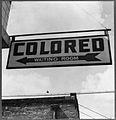
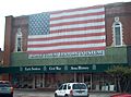
Sign at the Rome bus station from 1943
-
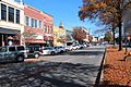
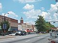
Downtown Rome
-
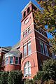
Historic Floyd County Courthouse
-
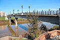
Chief John Ross pedestrian bridge


See also
 In Spanish: Rome (Georgia) para niños
