
Roosevelt, New Jersey facts for kids
Quick facts for kids
Roosevelt, New Jersey
|
|
|---|---|
|
Borough
|
|
| Borough of Roosevelt | |

Rochdale Avenue through Roosevelt
|
|

Map of Roosevelt in Monmouth County. Inset: Location of Monmouth County highlighted in the State of New Jersey.
|
|

Census Bureau map of Roosevelt, New Jersey
|
|
| Country | |
| State | |
| County | Monmouth |
| Incorporated | May 29, 1937 as Jersey Homesteads |
| Renamed | November 9, 1945 as Roosevelt |
| Government | |
| • Type | Borough |
| • Body | Borough Council |
| Area | |
| • Total | 1.95 sq mi (5.05 km2) |
| • Land | 1.94 sq mi (5.02 km2) |
| • Water | 0.01 sq mi (0.02 km2) 0.46% |
| Area rank | 416th of 565 in state 31st of 53 in county |
| Elevation | 144 ft (44 m) |
| Population | |
| • Total | 882 |
| • Estimate
(2019)
|
836 |
| • Rank | 538th of 566 in state 49th of 53 in county |
| • Density | 461.8/sq mi (178.3/km2) |
| • Density rank | 447th of 566 in state 50th of 53 in county |
| Time zone | UTC−05:00 (Eastern (EST)) |
| • Summer (DST) | UTC−04:00 (Eastern (EDT)) |
| ZIP Code |
08555
|
| Area code(s) | 609 |
| FIPS code | 3402564410 |
| GNIS feature ID | 0885377 |
Roosevelt is a borough in Monmouth County, New Jersey, United States. As of the 2010 United States Census, the borough's population was 882, reflecting a decline of 51 (-5.5%) from the 933 counted in the 2000 Census, which had in turn increased by 49 (+5.5%) from the 884 counted in the 1990 Census.
Located at the cross-roads between the Delaware Valley region to the south and the Raritan Valley region to the north in the center of the state, the borough was established as Jersey Homesteads by an act of the New Jersey Legislature on May 29, 1937, from portions of Millstone Township. The name was changed to Roosevelt as of November 9, 1945, based on the results of a referendum held three days earlier, in honor of Franklin D. Roosevelt, who had died on April 12, 1945.
New Jersey Monthly magazine ranked Roosevelt as its 12th best place to live in its 2008 rankings of the "Best Places To Live" in New Jersey.
Contents
History

|
Jersey Homesteads Historic District
|
|
 |
|
| Lua error in Module:Location_map at line 420: attempt to index field 'wikibase' (a nil value). | |
| NRHP reference No. | 83004053 |
|---|---|
| Significant dates | |
| Added to NRHP | December 5, 1983 |
Roosevelt was originally called Jersey Homesteads, and was created during the Great Depression as part of President Roosevelt's New Deal, its main purpose being to resettle Jewish garment workers. The town was conceived as an integrated cooperative project, with farming, manufacturing, and retail all on a cooperative basis. The project fell under the discretion of the Resettlement Administration, but was conceived and largely planned out by Benjamin Brown.
Farmland in Central Jersey was purchased by Jersey Homesteads, Inc., a corporation owned by the federal government but under control of a board of directors selected by Brown. Construction started around 1936. Soon after there were 200 homes and various public facilities in place. The economy of the town consisted of a garment factory and a farm. Objectives of the community were to help residents escape poverty, to show that cooperative management can work, and as an experiment in government intervention.
Albert Einstein gave the town his political and moral support. Artist Ben Shahn lived in the town and painted a fresco mural viewable in the current Roosevelt Public School. The three panels show the history of the Jersey Homesteads, starting with the eastern European origins of its Jewish residents, their passage through Ellis Island and making plans for the community in Roosevelt.
David Dubinsky and the International Ladies' Garment Workers' Union opposed the project, arguing that the factory town would cause unions to lose their power over wages. Political opposition came from those who thought too much money was being spent on the project, as well as those opposed to the New Deal in general.
The Jersey Homesteads cooperative didn't last through World War II. It failed for a number of reasons.
Roosevelt is a historic landmark and is the subject of the 1983 documentary, Roosevelt, New Jersey: Visions of Utopia. The Jersey Homesteads Historic District was added to the New Jersey Register of Historic Places and to the National Register of Historic Places in 1983, including "all that area within the corporate boundaries of the Borough of Roosevelt".
,_N.J._marker.jpg)
Geography
According to the United States Census Bureau, the borough had a total area of 1.920 square miles (4.972 km2), including 1.910 square miles (4.947 km2) of land and 0.010 square miles (0.026 km2) of water (0.52%).
The borough borders the Monmouth County municipalities of Upper Freehold Township on the southwest and Millstone Township on the north and east.
Demographics
| Historical population | |||
|---|---|---|---|
| Census | Pop. | %± | |
| 1940 | 698 | — | |
| 1950 | 720 | 3.2% | |
| 1960 | 764 | 6.1% | |
| 1970 | 814 | 6.5% | |
| 1980 | 835 | 2.6% | |
| 1990 | 884 | 5.9% | |
| 2000 | 933 | 5.5% | |
| 2010 | 882 | −5.5% | |
| 2019 (est.) | 836 | −5.2% | |
| Population sources: 1940–1990 2000 2010 |
|||
Census 2010
As of the census of 2010, there were 882 people, 314 households, and 241 families residing in the borough. The population density was 461.8 per square mile (178.3/km2). There were 327 housing units at an average density of 171.2 per square mile (66.1/km2)*. The racial makeup of the borough was 92.52% (816) White, 0.91% (8) Black or African American, 0.00% (0) Native American, 3.17% (28) Asian, 0.00% (0) Pacific Islander, 1.93% (17) from other races, and 1.47% (13) from two or more races. [[Hispanic (U.S. Census)|Hispanic or Latino of any race were 5.90% (52) of the population.
There were 314 households out of which 31.8% had children under the age of 18 living with them, 65.9% were married couples living together, 6.1% had a female householder with no husband present, and 23.2% were non-families. 17.5% of all households were made up of individuals, and 9.6% had someone living alone who was 65 years of age or older. The average household size was 2.81 and the average family size was 3.22.
In the borough, the population was spread out with 23.7% under the age of 18, 7.8% from 18 to 24, 17.5% from 25 to 44, 37.3% from 45 to 64, and 13.7% who were 65 years of age or older. The median age was 45.8 years. For every 100 females there were 98.2 males. For every 100 females ages 18 and old there were 93.9 males.
The Census Bureau's 2006–2010 American Community Survey showed that (in 2010 inflation-adjusted dollars) median household income was $81,000 (with a margin of error of +/- $13,354) and the median family income was $86,406 (+/- $11,892). Males had a median income of $48,571 (+/- $11,433) versus $40,909 (+/- $17,307) for females. The per capita income for the borough was $33,863 (+/- $6,772). About 4.7% of families and 8.6% of the population were below the poverty line, including 13.4% of those under age 18 and 6.5% of those age 65 or over.
Census 2000
As of the 2000 United States Census there were 933 people, 337 households, and 258 families residing in the borough. The population density was 477.0 people per square mile (183.8/km2). There were 351 housing units at an average density of 179.4 per square mile (69.1/km2). The racial makeup of the borough was 88.96% White, 2.57% African American, 2.04% Asian, 0.11% Pacific Islander, 2.25% from other races, and 4.07% from two or more races. Hispanic or Latino of any race were 4.50% of the population.
There were 337 households, out of which 39.5% had children under the age of 18 living with them, 64.1% were married couples living together, 7.7% had a female householder with no husband present, and 23.4% were non-families. 18.7% of all households were made up of individuals, and 11.3% had someone living alone who was 65 years of age or older. The average household size was 2.77 and the average family size was 3.17.
In the borough the population was spread out, with 27.8% under the age of 18, 5.9% from 18 to 24, 26.7% from 25 to 44, 27.5% from 45 to 64, and 12.1% who were 65 years of age or older. The median age was 40 years. For every 100 females, there were 92.8 males. For every 100 females age 18 and over, there were 87.7 males.
The median income for a household in the borough was $61,979, and the median income for a family was $67,019. Males had a median income of $50,417 versus $38,229 for females. The per capita income for the borough was $24,892. About 3.9% of families and 4.3% of the population were below the poverty line, including 4.0% of those under age 18 and 18.4% of those age 65 or over.
Transportation
_at_Nurko_Road_in_Roosevelt,_Monmouth_County,_New_Jersey.jpg)
As of May 2010[update], the borough had a total of 8.43 miles (13.57 km) of roadways, of which 6.27 miles (10.09 km) were maintained by the municipality and 2.16 miles (3.48 km) by Monmouth County.
The only major road that passes through is County Route 571, which traverses the center of the borough.
Interstate 195 is accessible in both of its neighboring towns. Interstate 95 (the New Jersey Turnpike) and Route 33 are also nearby.
Education
The Roosevelt Public School District serves public school students in pre-kindergarten through fifth grade at Roosevelt Public School. As of the 2018–19 school year, the district, comprised of one school, had an enrollment of 83 students and 9.5 classroom teachers (on an FTE basis), for a student–teacher ratio of 8.7:1. In the 2016–17 school year, Roosevelt had the 6th-smallest enrollment of any school district in the state, with 88 students.
For sixth through twelfth grades, public school students attend the East Windsor Regional School District, which serves students from East Windsor Township and Hightstown Borough, with students from Roosevelt attending as part of a sending/receiving relationship. Schools in the East Windsor district attended by Roosevelt students (with 2018–19 enrollment data from the National Center for Education Statistics) are Melvin H. Kreps Middle School with 1,230 students in grades 6 - 8 and Hightstown High School with 1,676 students in grades 9 - 12.
From 2005 to 2010, a Jewish secondary and post-secondary religious school, Yeshiva Me'on Hatorah, was located in a local synagogue, Congregation Anshei Roosevelt. Due to unresolvable zoning issues for its dormitory and dining facilities, and local opposition to its presence, the yeshiva relocated to Monsey, New York after the yeshiva brought and lost several actions against the borough and certain individual borough officials in state and Federal courts.
Notable people
People who were born in, residents of, or otherwise closely associated with Roosevelt include:
- Benjamin Brown (1885–1939), poultry trader who developed Roosevelt.
- John Stanley Grauel (1917–86), Methodist minister and Zionist leader.
- Lois Hunt (1925–2009), soprano opera singer who toured for decades with baritone Earl Wrightson.
- Louis Kahn (1901-1974), assistant architect for the Jersey Homesteads, who later designed internationally famous buildings.
- Irwin Lachman (born 1930), one of the inventors of the catalytic converter.
- Jacob Landau (1917–2001), printmaker, painter, and humanist.
- David Stone Martin (1913–1992), artist best known for his designs for jazz album covers.
- Stefan Martin (1936-1994), printmaker.
- Gregorio Prestopino (1907–1984), Social realist painter of the New Deal era.
- Louise Rosskam (1910–2003), documentary photographer.
- Ben Shahn (1898–1969), Social realist painter.
- Bernarda Bryson Shahn (1903–2004), painter and wife of Ben Shahn.
- Jonathan Shahn (born 1938-2021), noted sculptor and son of Ben and Bernarda Shahn.
Images for kids
-
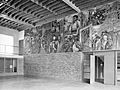
Ben Shahn's untitled fresco for the Jersey Homesteads, completed in 1938

See also
 In Spanish: Roosevelt (Nueva Jersey) para niños
