
Rosewood, New South Wales facts for kids
Quick facts for kids RosewoodNew South Wales |
|||||||||
|---|---|---|---|---|---|---|---|---|---|

War memorial at Rosewood, 2020
|
|||||||||

Rosewood
Location in New South Wales
|
|||||||||
| Population | 214 (2016 census) | ||||||||
| Postcode(s) | 2652 | ||||||||
| Elevation | 435 m (1,427 ft) | ||||||||
| Location |
|
||||||||
| LGA(s) |
|
||||||||
| County | Selwyn | ||||||||
| State electorate(s) | Albury | ||||||||
| Federal Division(s) | Eden-Monaro | ||||||||
|
|||||||||
Rosewood is a village community and locality in the south east part of the Riverina, New South Wales, Australia. It is situated about 16 kilometres (9.9 mi) south east from Carabost and 19 kilometres (12 mi) north west from Tumbarumba. At the 2016 census, Rosewood had a population of 214. The village is administered by two local governments; the northern part of the locality by the Greater Hume Shire and the southern part of the locality by the Snowy Valleys Council. The village of Rosewood is within the Snowy Valleys Council area.
Images for kids
-
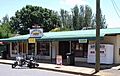
Rosewood General Store and Post Office


All content from Kiddle encyclopedia articles (including the article images and facts) can be freely used under Attribution-ShareAlike license, unless stated otherwise. Cite this article:
Rosewood, New South Wales Facts for Kids. Kiddle Encyclopedia.