
Rosholt, Wisconsin facts for kids
Quick facts for kids
Rosholt, Wisconsin
|
|
|---|---|
|
Village
|
|

Location of Rosholt in Portage County, Wisconsin.
|
|
| Country | |
| State | |
| County | Portage |
| Area | |
| • Total | 1.09 sq mi (2.81 km2) |
| • Land | 1.05 sq mi (2.72 km2) |
| • Water | 0.04 sq mi (0.09 km2) |
| Elevation | 1,138 ft (347 m) |
| Population
(2010)
|
|
| • Total | 506 |
| • Estimate
(2019)
|
486 |
| • Density | 462.86/sq mi (178.66/km2) |
| Time zone | UTC-6 (Central (CST)) |
| • Summer (DST) | UTC-5 (CDT) |
| Zip code |
54473
|
| Area code(s) | 715 & 534 |
| FIPS code | 55-69575 |
| GNIS feature ID | 1572619 |
Rosholt is a village in Portage County, Wisconsin, United States. The population was 506 at the 2010 census.
History
The person recorded as first owning the land on which Rosholt sits is Gottlieb Stanbly. Stanbly received four 40-acre (160,000 m2) parcels directly from the U.S. Government on May 10, 1858 because he was a veteran. Gottlieb Stanbly sold the land to Theodor Stanbly in 1861 for $430 when Gottlieb left the area to fight in the Civil War. Theodor sold the land to Jens Rasmussen in 1867 for $400. Rasmussen created a millpond by damming Flume Creek, and built a water-driven feed mill sometime between 1867 and 1881. John Gilbert (J.G.) Rosholt built the first sawmill in town on the east end of the millpond in 1884, after making a deal to share water rights with Rasmussen. J.G. Rosholt’s first mill burned in 1901, but it was rebuilt later that year and into 1902. The first survey and platting of Rosholt was done on June 1, 1903 at J.G. Rosholt’s request. Rosholt was incorporated in 1907 and was named after J.G. Rosholt, who was elected the first village president on April 7, 1908.
Geography
Rosholt is located at 44°37′50″N 89°18′27″W / 44.63056°N 89.30750°W (44.630421, -89.307414).
According to the United States Census Bureau, the village has a total area of 1.10 square miles (2.85 km2), of which, 1.06 square miles (2.75 km2) of it is land and 0.04 square miles (0.10 km2) is water.
Demographics
| Historical population | |||
|---|---|---|---|
| Census | Pop. | %± | |
| 1910 | 383 | — | |
| 1920 | 448 | 17.0% | |
| 1930 | 515 | 15.0% | |
| 1940 | 523 | 1.6% | |
| 1950 | 508 | −2.9% | |
| 1960 | 497 | −2.2% | |
| 1970 | 466 | −6.2% | |
| 1980 | 520 | 11.6% | |
| 1990 | 512 | −1.5% | |
| 2000 | 518 | 1.2% | |
| 2010 | 506 | −2.3% | |
| 2019 (est.) | 486 | −4.0% | |
| U.S. Decennial Census | |||
2010 census
As of the census of 2010, there were 506 people, 208 households, and 136 families living in the village. The population density was 477.4 inhabitants per square mile (184.3/km2). There were 227 housing units at an average density of 214.2 per square mile (82.7/km2). The racial makeup of the village was 98.4% White, 1.4% Native American, and 0.2% from two or more races. Hispanic or Latino of any race were 3.2% of the population.
There were 208 households, of which 36.1% had children under the age of 18 living with them, 46.2% were married couples living together, 13.0% had a female householder with no husband present, 6.3% had a male householder with no wife present, and 34.6% were non-families. 28.8% of all households were made up of individuals, and 10.1% had someone living alone who was 65 years of age or older. The average household size was 2.43 and the average family size was 3.02.
The median age in the village was 36.4 years. 27.5% of residents were under the age of 18; 6% were between the ages of 18 and 24; 30.6% were from 25 to 44; 23.6% were from 45 to 64; and 12.1% were 65 years of age or older. The gender makeup of the village was 50.8% male and 49.2% female.
Special events
Rosholt hosts the Portage County/Rosholt/The Worlds Fair every Labor Day weekend on their fairgrounds, which attracts all ages with games, food, carnival rides, animal showings, bands, and the slow-pitch softball tournament. The fair park also hosts annually the Rosholt Fireworks on the Fourth of July, Good Times in the Pines, The Thresheree, and a Blue Grass Festival.
Gallery
-
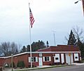
Village hall
-
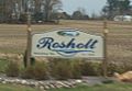
Welcome sign
-
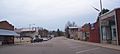
Downtown Rosholt


See also
 In Spanish: Rosholt (Wisconsin) para niños
