Rossmoyne, Ohio facts for kids
Quick facts for kids
Rossmoyne, Ohio
|
|
|---|---|

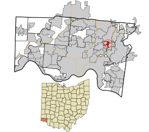
Location in Hamilton County and the state of Ohio
|
|
| Country | United States |
| State | Ohio |
| County | Hamilton |
| Area | |
| • Total | 0.6 sq mi (1.5 km2) |
| • Land | 0.6 sq mi (1.5 km2) |
| • Water | 0 sq mi (0 km2) |
| Elevation | 840 ft (260 m) |
| Population
(2010)
|
|
| • Total | 2,230 |
| • Density | 3,850/sq mi (1,490/km2) |
| Time zone | UTC-5 (Eastern (EST)) |
| • Summer (DST) | UTC-4 (EDT) |
| ZIP code |
45236
|
| FIPS code | 39-68714 |
| GNIS feature ID | 1065248 |
Rossmoyne is a census-designated place (CDP) in Sycamore Township, Hamilton County, Ohio, United States, 13 miles (21 km) northeast of downtown Cincinnati. The population of Rossmoyne was 2,230 at the 2010 census.
Geography
Rossmoyne is located at 39°12′49″N 84°23′12″W / 39.21361°N 84.38667°W. It is bordered by Deer Park to the south, Dillonvale to the west, Blue Ash to the north, and Kenwood to the east.
According to the United States Census Bureau, the CDP has a total area of 0.58 square miles (1.5 km2), all land.
See also
 In Spanish: Rossmoyne (Ohio) para niños

All content from Kiddle encyclopedia articles (including the article images and facts) can be freely used under Attribution-ShareAlike license, unless stated otherwise. Cite this article:
Rossmoyne, Ohio Facts for Kids. Kiddle Encyclopedia.
