
Rutledge, Tennessee facts for kids
Quick facts for kids
Rutledge, Tennessee
|
|
|---|---|
| City of Rutledge | |

Grainger County Courthouse in Rutledge
|
|

Location of Rutledge in Grainger County, Tennessee.
|
|
| Country | United States |
| State | Tennessee |
| County | Grainger |
| Incorporated | 1797 |
| Reincorporated | 1955 |
| Named for | George Rutledge |
| Government | |
| • Type | Mayor-aldermen |
| Area | |
| • Total | 5.54 sq mi (14.34 km2) |
| • Land | 5.53 sq mi (14.33 km2) |
| • Water | 0.01 sq mi (0.01 km2) |
| Elevation | 1,017 ft (310 m) |
| Population
(2010)
|
|
| • Total | 1,122 |
| • Estimate
(2019)
|
1,355 |
| • Density | 244.98/sq mi (94.59/km2) |
| Time zone | UTC-5 (Eastern (EST)) |
| • Summer (DST) | UTC-4 (EDT) |
| ZIP code |
37861
|
| Area code(s) | 865 |
| FIPS code | 47-65820 |
| GNIS feature ID | 1269919 |
Rutledge is a city in and the county seat of Grainger County, Tennessee. The city is part of both the Knoxville metropolitan area and the Morristown metropolitan area. As of the 2010 census, the city had a total population of 1,122, a decrease of 65 from 2000.
History
Rutledge was established in 1797 and named for General George Rutledge, a prominent citizen in nearby Sullivan County. In 1801, Rutledge became the official county seat of Grainger County, a distinction that had been shared by several communities since the county's formation in 1796. Rutledge prospered in the early 19th century in part due to its situation along the Federal Road (now US-11W), which connected New Orleans and Virginia. The road intersected the Old Kentucky Road (now US-25E) at Bean Station, just east of Rutledge.

In the 1820s, future president Andrew Johnson, who worked as a tailor in Greeneville, briefly operated a tailor shop in Rutledge. In 1976, a replica of Johnson's tailor shop was erected on the Grainger County Courthouse lawn.
During the U.S. Civil War, guerilla warfare largely paralyzed Grainger County. In December 1863, Confederate General James Longstreet, who had earlier failed to wrest Knoxville from Union forces, passed through Rutledge en route to winter quarters at Russellville. On December 14, in what became known as the Battle of Bean's Station, Longstreet attacked a Union detachment that had been pursuing him. The Confederates failed to exploit the element of surprise, and the Union forces were able to hold out until reinforcements arrived. While Longstreet was victorious, Union forces were able to retreat to fortifications at Blaine, and Longstreet subsequently abandoned the assault and continued eastward to Russellville.
Cherokee Lake, created by the Tennessee Valley Authority in 1941 with the completion of Cherokee Dam, is located just south of Rutledge.
Geography
Rutledge is located at 36°16′48″N 83°31′5″W / 36.28000°N 83.51806°W (36.279991, -83.518008). The town is situated near the center of Richland Valley, a narrow valley that stretches for some 35 miles (56 km) along the southern base of Clinch Mountain between Blaine and Bean Station. Richland Creek traverses most of the valley en route to its confluence along the Cherokee Lake impoundment of the Holston River, approximately 20 miles (32 km) downstream from Rutledge. Cherokee Lake's Ray Creek embayment is located approximately 10 miles (16 km) east of Rutledge.
Rutledge is centered around the junction of U.S. Route 11W, which connects the town to Kingsport to the east and Knoxville to the west, and State Route 92, which connects the town to Jefferson County and Interstate 40 to the south. U.S. Route 25, which traverses Clinch Mountain, intersects US-11W approximately 10 miles (16 km) east of Rutledge.
According to the United States Census Bureau, the town has a total area of 4.7 square miles (12 km2), all land.
Demographics
| Historical population | |||
|---|---|---|---|
| Census | Pop. | %± | |
| 1870 | 107 | — | |
| 1880 | 126 | 17.8% | |
| 1890 | 143 | 13.5% | |
| 1960 | 793 | — | |
| 1970 | 863 | 8.8% | |
| 1980 | 1,058 | 22.6% | |
| 1990 | 903 | −14.7% | |
| 2000 | 1,187 | 31.5% | |
| 2010 | 1,122 | −5.5% | |
| 2019 (est.) | 1,355 | 20.8% | |
| Sources: | |||
2020 census
| Race | Number | Percentage |
|---|---|---|
| White (non-Hispanic) | 1,238 | 93.72% |
| Black or African American (non-Hispanic) | 10 | 0.76% |
| Native American | 3 | 0.23% |
| Asian | 5 | 0.38% |
| Pacific Islander | 1 | 0.08% |
| Other/Mixed | 45 | 3.41% |
| Hispanic or Latino | 19 | 1.44% |
As of the 2020 United States census, there were 1,321 people, 611 households, and 355 families residing in the town.
Notable people
- Samuel Bunch (1786–1849), Congressman and state legislator
- John Alexander Cocke (1772–1854), Congressman and rival of Andrew Jackson during the Creek War
- William Michael Cocke (1815–1896), Congressman and state legislator
- A. W. Davis (1943–2014), All-American basketball player at the University of Tennessee
- Robert Taylor Jones (1884–1958), ninth governor of Arizona, was born in Rutledge.
- James F. Lawrence Jr. (1918–2006), American Marine Corps Navy Cross recipient, lawyer
- Harold Theodore Tate (1875–1960), 26th Treasurer of the United States under President Calvin Coolidge
Images for kids
-
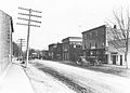
Downtown Rutledge, circa 1910s

See also
 In Spanish: Rutledge (Tennessee) para niños
