
São Vicente, Cape Verde facts for kids
|
Native name:
Sonsent
Nickname: Ilha do Porto Grande (island of Porto Grande)
|
|
|---|---|
 |
|
 |
|

São Vicente
Location in Cape Verde
|
|
| Geography | |
| Location | Atlantic Ocean |
| Coordinates | 16°51′N 24°58′W / 16.850°N 24.967°W |
| Area | 226.7 km2 (87.5 sq mi) |
| Length | 24.3 km (15.1 mi) |
| Width | 16.3 km (10.13 mi) |
| Highest elevation | 744 m (2,441 ft) |
| Highest point | Monte Verde |
| Administration | |
| Municipality | São Vicente |
| Largest settlement | Mindelo |
| Demographics | |
| Population | 81,014 (2015) |
| Pop. density | 357 /km2 (925 /sq mi) |
São Vicente is an island of Cape Verde. It is in the Barlavento Islands group. São Vicente was discovered by the Portuguese discoverer Diogo Afonso on 22 January 1462.
92% of the island population lives in the urban area of Mindelo. It is on the Porto Grande Bay. Mindelo is the capital city of the municipality.
São Vicente has a hot and dry climate. The average annual temperature in Mindelo is 23.6 °C (74 °F).
Images for kids
-
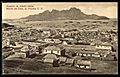
Mindelo in the early 20th century
-
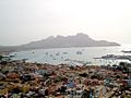
View of Downtown Mindelo, Baía do Porto Grande and Monte Cara
-
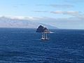
Landscape view of Ilhéu dos Pássaros, Cape Verde


See also
 In Spanish: Isla de São Vicente para niños

All content from Kiddle encyclopedia articles (including the article images and facts) can be freely used under Attribution-ShareAlike license, unless stated otherwise. Cite this article:
São Vicente, Cape Verde Facts for Kids. Kiddle Encyclopedia.