
Sahiwal Division facts for kids
Quick facts for kids
Sahiwal Division
ساہیوال
|
|
|---|---|
.svg)
Location of Sahiwal (in red) in Punjab, Pakistan and (inset) Punjab in Pakistan.
|
|
| Country | Pakistan |
| Province | Punjab |
| Capital | Sahiwal |
| Established | 2008 |
| Districts | 3 |
| Government | |
| • Type | Divisions |
| Area | |
| • Total | 10,302 km2 (3,978 sq mi) |
| Population
(2017)
|
|
| • Total | 7,380,386 |
| • Density | 716.40/km2 (1,855.48/sq mi) |
| Combined population of all Districts of Sahiwal | |
| Main language(s) | |
| Time zone | UTC+5 (PST) |
| Postal code |
57000
|
| Dialling code | 040 |

Sahiwal Division (Punjabi, Urdu: ساہیوال) is one of the nine Divisions of Punjab province, Pakistan. In 1998, the population of Sahiwal was 6,271,247. The population rate of growth was 1.92 percent per annum. In 2008, Sahiwal Division was divided into three districts: Sahiwal District, Okara District and Pakpattan District. The city of Sahiwal is the capital of both Sahiwal District and Sahiwal Division.
About 18 miles (29 km) southwest of Sahiwal is Harappa, an ancient city of the Indus Valley civilisation. About 28 miles (45 km) west of Sahiwal, at Kamalia township, is the site of Malli, a city captured by Alexander the Great in 325 BCE. Alexander stayed in this region of Punjab for two years in a time of frequent military conflict.
In 1849, Pakpattan administrative district was created in the area between Lahore and Multan. In 1851, Pakpattan's headquarters was moved to Gogera. The Pakpattan administrative district was renamed the Gogera district. In September 1858, Rai Ahmed Nawaz Khan Kharal, a land holder in the Gogera region, fought in India's First War of Independence. His comrades were Murad Fatiana, Shujaa Bhadur, and Mokha Wehniwal. Khan's fight for independence from the British raj led to his own death and that of the commissioner for Gogera, a man called Berkeley (Berkley).
The insurrection was centered in a wide area including Ganji Bar, Neeli Bar and Sandal Bar. The arena of conflict was bordered by the Sutlej river, the Ravi River and Chenab River. The area was thickly forested and suitable for resistance actions. For instance, Major Crawford Chamberlain was ambushed at Chichawatni.
In 1854, railway was laid between Lahore and Multan and a station was built at Gogera. The area was renamed "Sahiwal" after the Sahi Clan of the Kharal tribe of the Jat people, the traditional inhabitants of the area.
In 1865, the name of the area was changed from "Sahiwal" to "Montgomery" after Sir Robert Montgomery (1809 - 1897), the Lieutenant Governor of Punjab. The name "Sahiwal" was reinstated in 1966.
Location

Sahiwal Division is located at about 30.6 degrees north latitude and 73.1 degrees longitude in east central Pakistan in the Punjab region. It lies on the Pakistan national highway N-5 about halfway between Lahore and Multan. Sahiwal division is bordered by Faisalabad Division to the west; Lahore Division to the north; Bahawalpur Division and India to the east; and, Multan Division to south.
Sahiwal division lies on the floodplain of two rivers. Ravi River lies to the west; and, Satluj River lies to the east. The dry Khushak Bias also passes through the Sahiwal Division, separating the Sahiwal District from the Pakpattan District.
Almost 28,956 acres of the division is forested.
The Sahiwal Division lies 500 ft (150 m) above sea level.
Images for kids
-
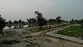
Okara Public Park
-
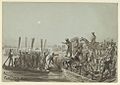
British troops crossing the Sutlej river, Punjab, 10 February 1846
-
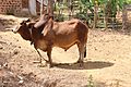
Sahiwala bull
-
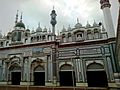
Interior of Sunni Mosque at Main Road Tariq Bin Zyad Colony, Sahiwal
.jpg)
_in_boats._10_February_1846.jpg)

.jpg)
See also
 In Spanish: División de Sahiwal para niños
