
Saibai Island facts for kids
|
Native name:
Saibai Saibai Saybay |
|
|---|---|
.png)
Landsat image of Saibai Island
|
|

A map of the Torres Strait Islands showing Saibai in the north central waters of Torres Strait
|
|
| Geography | |
| Coordinates | 9°24′S 142°41′E / 9.400°S 142.683°E |
| Archipelago | Torres Strait Islands |
| Adjacent bodies of water | Torres Strait |
| Major islands | Saibai, Kauamag |
| Area | 107.9 km2 (41.7 sq mi) |
| Length | 21.8 km (13.55 mi) |
| Width | 5.2 km (3.23 mi) |
| Highest elevation | 1.7 m (5.6 ft) |
| Highest point | unnamed |
| Administration | |
|
Australia
|
|
| State | Queensland |
| Local government area | Torres Strait Islands Regional Council |
| Island Region | Top Western |
| Largest settlement | Saibai (pop. 171) |
| Demographics | |
| Population | 465 (2016 census) |
| Pop. density | 4.3 /km2 (11.1 /sq mi) |
| Ethnic groups | Torres Strait Islanders |
| Saibai Island Queensland |
|||||||||||||||
|---|---|---|---|---|---|---|---|---|---|---|---|---|---|---|---|
| Population | 465 (2016 census) | ||||||||||||||
| • Density | 4.537/km2 (11.75/sq mi) | ||||||||||||||
| Postcode(s) | 4875 | ||||||||||||||
| Area | 102.5 km2 (39.6 sq mi) | ||||||||||||||
| Time zone | AEST (UTC+10:00) | ||||||||||||||
| LGA(s) | Torres Strait Island Region | ||||||||||||||
| State electorate(s) | Cook | ||||||||||||||
| Federal Division(s) | Leichhardt | ||||||||||||||
|
|||||||||||||||
Saibai Island, often shortened to just Saibai (Kala Lagaw Ya: Saybay), is an island of the Torres Strait Islands archipelago, located in the Torres Strait of Queensland, Australia. The island is situated north of the Australian mainland and south of the island of New Guinea. The island is a locality within the Torres Strait Island Region local government area. The town of Saibai is located on the north-west coast of the island. According to the 2016 census, Saibai Island had a population of 465 people.
Most of the island is held under native title, apart from some government infrastructure and historic buildings.
Contents
Geography
The island was formed by alluvial deposits from Papua New Guinean rivers.
Saibai Island is a fairly large low-lying island located 8 kilometres (5.0 mi) south of the Papua New Guinea mainland. Close to the north of Saibai is the uninhabited Kauamag Island, separated from Saibai by a channel that is 7 kilometres (4.3 mi) long, between 180 and 650 metres (590 and 2,130 ft) wide, and nearly blocked at its east end.
The island is about 21.8 kilometres (13.5 mi) in length by 5.2 kilometres (3.2 mi) in width, and is flat, predominantly mangrove swamplands, with the highest point being 1.7 metres (5 ft 7 in) above mean sea level, and prone to flooding during the wet season, which coincides with king tides. A bitumen airstrip allows year-round access.
The main village of Saibai, in the northwest, has a population of 171. The second village, Churum [Surum White Sand], in the southwest, numbers 128.
Islanders
Only a small proportion of the island is inhabited. The population is transient and was recorded as 337 people at the 2006 census census. The population is 70% indigenous, Torres Strait Islander people, with 25% Papuan and 5% White Australian.
The language spoken on Saibai is Kalaw Kawaw Ya (KKY). Saibai Islanders have always traded and had good relations with neighbouring Papuans.
History
After Saibai Island was devastated by abnormally high tides wave after World War Two, a group of Saibai islanders, led by Bamaga Ginau, accepted Government assistance to resettle on Cape York. The village of Saibai was totally flooded by 10 metres (33 ft) of water. Erosion and a lack of freshwater were concerns. Once a site was chosen inland of Red Island, the new town was named Bamaga. Later some moved to a new settlement at Red Island Point on the coast and named it Seisia.
In January 2012, very high tides inundated the island's cemetery and damaged sacred gravesites.
Heritage listings
Saibai Island has a number of heritage-listed sites, including the Holy Trinity Church.
Demographics
Islanders
Only a small proportion of the island is inhabited. In the 2016 Census, there were 465 people in Saibai Island. 84.0% of people were born in Australia. Torres Strait Islander and Aboriginal people made up 85.6% of the population, with 70% of the population claiming Torres Strait Islander ancestry. The most common response for religion was Anglican at 44.9%.
The language spoken on Saibai is Kalaw Kawaw Ya (KKY). Saibai Islanders have always traded and had good relations with neighbouring Papuans. The Saibai Islanders converted to Christianity in 1871 with the arrival of the London Missionary Society.
Saibai, Boigu and Dauan society is Buwai "clan/moiety" based, there being two major Buwai (moieties), the Koei Buwai "Great Moiety" and the Moegina Buwai "Lesser Moiety"; each moiety is divided into totemic subclans, such as the Samu Augadh "Cassowary Totem" (Koei Buwai), Koedal Augadh "Crocodile Totem" (Moegina Buwai) and others. All social, food gathering, family business and traditional religion circles around clan relationships.
The Saibaians have been legally acknowledged as being the traditional owners of Saibai.
They are of Melanesian origin and lived in village communities following traditional patterns of hunting, fishing, agriculture and trade for many thousands of years before contact was made with the first European, Asian and Pacific Island visitors to the region. Strong kinship and trade ties exist between the people of Saibai, Mt Cornwallis and Boigu Island, with less strong but still important ties with the neighbouring Papuan communities.
Ancestry
| Ancestry | Number | Percentage |
|---|---|---|
| Torres Strait Islanders | 360 | 70.0% |
| 82 | 16.0% | |
| 10 | 2.9% | |
| 4 | 0.8% | |
| 4 | 0.8% |
Birthplace
| Country | Number | Percentage |
|---|---|---|
| 389 | 84.0% | |
| 52 | 11.2% |
Language
79.5% of households in Saibai spoke a language other than English at home.
| Language | Number | Percentage |
|---|---|---|
| Kala Lagaw Ya | 108 | 23.1% |
| Torres Strait Creole | 70 | 15.0% |
| English | 20 | 4.3% |
Religion
93.0% of Saibai Islanders follow Christianity.
| Religion | Number | Percentage |
|---|---|---|
| Anglicanism | 213 | 44.9% |
| Not stated | 65 | 13.7% |
| Catholicism | 58 | 12.2% |
| Christianity (not further defined) | 33 | 7.0% |
| Uniting Church | 29 | 6.1% |
Education
Saibai Island Campus is a primary (Early Childhood-6) school at 5 School Road (9°22′46″S 142°37′26″E / 9.3794°S 142.6239°E), part of the Tagai State College which has 17 campuses throughout the Torres Strait.
There is no secondary school on the island; the nearest is on Thursday Island.
Images for kids
-
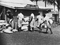
Saibai women help unload produce for the general store on Saibai Island, 1952. The Saibai Island I.I.B. Store is being re-stocked with produce. Several women and men are unloading sacks and barrels and taking them to the store.

