
Saint-Florent, Haute-Corse facts for kids
Quick facts for kids
Saint-Florent
San Fiurenzu
|
||
|---|---|---|
|
Citadel
|
||
|
||

Saint-Florent
Location in France

Saint-Florent
Location in Corsica
|
||
| Country | France | |
| Region | Corsica | |
| Department | Haute-Corse | |
| Arrondissement | Calvi | |
| Canton | Biguglia-Nebbio | |
| Area
1
|
17.98 km2 (6.94 sq mi) | |
| Population
(Jan. 2021)
|
Lua error in Module:Wd at line 1,575: attempt to index field 'wikibase' (a nil value). | |
| Time zone | UTC+01:00 (CET) | |
| • Summer (DST) | UTC+02:00 (CEST) | |
| INSEE/Postal code |
2B298 /20217
|
|
| Elevation | 0–356 m (0–1,168 ft) (avg. 10 m or 33 ft) |
|
| 1 French Land Register data, which excludes lakes, ponds, glaciers > 1 km2 (0.386 sq mi or 247 acres) and river estuaries. | ||
.jpg)
.svg)
Saint-Florent (Corsican: San Fiurenzu) is a commune in Haute-Corse, Corsica, France. It is a fishing port located near the gulf of the same name (Saint-Florent Gulf).
Today, it is a popular summer vacation spot for many tourists for one of the most beautiful beaches on the Mediterranean coast, Saleccia.
Climate
Saint-Florent has a typically Mediterranean climate - mild winters with temperatures rarely under zero, warm, dry summers with temperatures at around 35°C in July and August.
History
Saint-Florent was created by the Genoese in the 16th century as a base for to fight the Corsican patriots in their villages. The colonial state and imperialist France later used it for getting troops of mercenaries and colonists during August 1764. After the defeat at Ponte Novu Bridge, the army of Pasquale Paoli, helped by Horatio Nelson, reconquered Saint-Florent in 1793 during the brief Anglo-Corsican rule.
Important places
The Genoise citadel constructed in 1440.
Images for kids
-
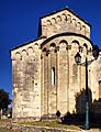
Saint-Florent Cathedral

See also
 In Spanish: Saint-Florent (Alta Córcega) para niños
