
Saint-Flour, Cantal facts for kids
Quick facts for kids
Saint-Flour
|
||
|---|---|---|

Saint-Flour - the lower town
|
||
|
||

Saint-Flour
Location in France

Saint-Flour
Location in Auvergne-Rhône-Alpes
|
||
| Country | France | |
| Region | Auvergne-Rhône-Alpes | |
| Department | Cantal | |
| Arrondissement | Saint-Flour | |
| Canton | Capital of 2 cantons | |
| Intercommunality | Saint-Flour Communauté | |
| Area
1
|
27.14 km2 (10.48 sq mi) | |
| Population
(2014)
|
6,643 | |
| • Density | 244.77/km2 (633.95/sq mi) | |
| Demonym(s) | Sanflorain | |
| Time zone | UTC+01:00 (CET) | |
| • Summer (DST) | UTC+02:00 (CEST) | |
| INSEE/Postal code |
15187 /15100
|
|
| Elevation | 757–1,040 m (2,484–3,412 ft) (avg. 783 m or 2,569 ft) |
|
| Website | www.saint-flour.fr | |
| 1 French Land Register data, which excludes lakes, ponds, glaciers > 1 km2 (0.386 sq mi or 247 acres) and river estuaries. | ||
.svg)
Saint-Flour (Occitan: Sant Flor) is a commune in south central France in the region of Auvergne-Rhône-Alpes. It is a subprefecture of the Cantal department. It is also the capital of the arrondissement of the same name.
Contents
History
Saint-Flour is the historical capital of the old region of Haute-Auverge ("Upper Auvergne"), one of the two divisions of Auvergne.
After the creation of the Cantal department on 4 March 1790, Saint-Flour was named as the capital (prefecture) of the new department alternating with Aurillac. In 1794, Saint-Flour became the only capital but, in 1795, the capital was moved to Aurillac and Saint-Flour became a subprefecture.
Geography
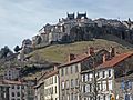
Saint-Flour is in the eastern part of Cantal. The city is divided in two parts:
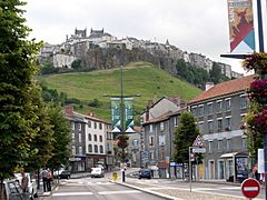
- The upper city (French: Ville haute) is on a volcanic dike
- The lower city (French: Ville basse) is on the sides of the Ander river, a right tributary of the Truyère river.
The commune of Saint-Flour has an area of 27.14 km2 (10.48 sq mi) and is surrounded by the communes Alleuze, Andelat, Coren, Roffiac, Saint-Georges and Villedieu.
 |
 |
Roffiac | Andelat | Coren | |
| Villedieu | Saint-Georges | |||
| Villedieu | Alleuze | Saint-Georges |
Climate
The climate of Saint-Flour, in the Köppen climate classification, is Cfb - Oceanic climate with template summers.
Population
The inhabitants of Saint-Flour are known, in French, as Sanflorain (women: Sainfloraine).
With a population of 6,643, Saint-Flour has a population density of 245 inhabitants/km2.
Evolution of the population in Saint-Flour
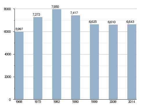
Saint-Flour forms the urban area of Saint-Flour, one of the seven urban areas of Cantal, with a population of 6,626 inhabitants (2013) and an area of 2,711 km2 (1,047 sq mi). This urban area is the centre of the metropolitan area of Saint-Flour, formed by 17 communes with a population of 13,024 inhabitants and an area of 326.8 km2 (126.2 sq mi).
Administration
Saint-Flour is a subprefecture of the Cantal department, the capital of the arrondissement of Saint-Flour and the administrative centre (French: chef-lieu) of three cantons:
- Saint-Flour-1 : 23 communes + part of Saint-Flour, with 9,696 inhabitants (2014)
- Saint-Flour-2 : 18 communes + part of Saint-Flour, with 9,171 inhabitants (2014)
It is part of the intercommunality Saint-Flour Communauté.
Sister cities
Saint-Flour is twinned with:
Gallery
-
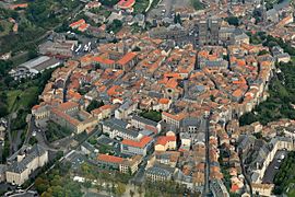
Aerial view of the upper town, Saint-Flour
-
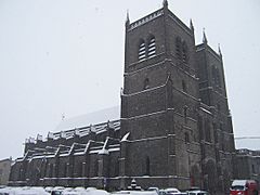
The Saint-Pierre cathedral of Saint-Flour
-
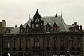
Saint-Flour
-
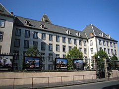
Lycée Notre-Dame de Saint-Flour


_Dscn0354-zh.jpg)

Related pages
Images for kids
-
Tourist office
-
The upper part of the town with its wall
-
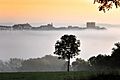
Upper part of the town in the mist


See also
 In Spanish: Saint-Flour (Cantal) para niños
