
Saint-Lô facts for kids
Quick facts for kids
Saint-Lô
|
||
|---|---|---|
|
Prefecture and commune
|
||
|
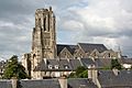
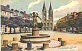
A view of Saint-Lô from the Notre-Dame church
|
||
|
||

Saint-Lô
Location in France

Saint-Lô
Location in Normandy
|
||
| Country | France | |
| Region | Normandy | |
| Department | Manche | |
| Arrondissement | Saint-Lô | |
| Canton | Saint-Lô-1 and 2 | |
| Intercommunality | Saint-Loise | |
| Area
1
|
23.19 km2 (8.95 sq mi) | |
| Population
(Jan. 2021)
|
Lua error in Module:Wd at line 1,575: attempt to index field 'wikibase' (a nil value). | |
| Time zone | UTC+01:00 (CET) | |
| • Summer (DST) | UTC+02:00 (CEST) | |
| INSEE/Postal code |
50502 /50000
|
|
| Elevation | 7–134 m (23–440 ft) (avg. 14 m or 46 ft) |
|
| 1 French Land Register data, which excludes lakes, ponds, glaciers > 1 km2 (0.386 sq mi or 247 acres) and river estuaries. | ||


Saint-Lô is a commune in north-western France, the capital of the Manche department in the region of Normandy.
Although it is the second largest city of Manche after Cherbourg, it remains the prefecture of the department. It is also chef-lieu of an arrondissement and two cantons (Saint-Lô-1 and Saint-Lô-2).
The commune has 18,931 inhabitants who are called Saint-Lois(es). The names of Laudois(es), Laudien(ne)s or Laudinien(ne)s are also cited. A martyr city of World War II, Saint-Lô was decorated with the Legion of Honour in 1948 and was given the nickname "Capital of the Ruins", a phrase popularised by Samuel Beckett.
Geography
Location


Saint-Lô is located in the centre of Manche, in the middle of the Saint-Lois bocage, 57 km (35 mi) to the west of Caen, 78 km (48 mi) south of Cherbourg and 119 km (74 mi) north of Rennes.
The city was born under the name of Briovera on a rocky outcrop of schist belonging to the Armorican Massif, in the Cotentin Peninsula, between the confluences of the Vire – which dominates the city centre – with the Dollée and Torteron, two rivers channelled in their urban sections. This historic heart of the city became L'Enclos, a site well suited to passive defence.
The east of the territory is the former commune of Sainte-Croix-de-Saint-Lô, south of Saint-Thomas-de-Saint-Lô, absorbed in 1964.
Climate

Saint-Lô has a mild oceanic climate characterised by mild winters and temperate summers. It has an average annual rainfall of 800 to 900 mm (31 to 35 in) per year. Rainfall is quite frequent throughout the year but most abundant in autumn and winter, in connection with the disturbances coming from the Atlantic Ocean. Rarely intense, they often fall in the form of drizzle. The average temperature is 10 °C (50 °F). In winter, the average temperature ranges between 1 and 7 °C (34 and 45 °F). There are between 30 and 40 days of frost per year. In summer, the average temperature lies around 20 °C (68 °F).
Economy

The city, at a crossroads between Caen, Cherbourg and Rennes, has a natural vocation of marketplace in the centre of the Manche bocage. A city of craftsmen and trade, which owes part of its prosperity to its status of prefecture, it has experienced a late industrialisation and attempts to assert its place, today, in the regional agri-food industry.
In 2008, Saint-Lô was equipped with fibre optic cable to allow companies and individuals to have very high speed internet (approximately 1 Gbps and 100 Mbit/s for individuals).
Sister cities
Saint-Lô is twinned with:
 Saint-Ghislain, Belgium, since 1961
 Aalen, Germany, since 1979
 Christchurch, UK, since 1985
 Kervénanec, Lorient, France, since 1988
 Roanoke, USA, since 1999
Images for kids
-
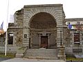
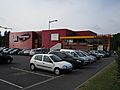
The main entrance to the town.
-
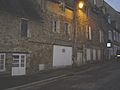
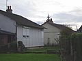
There remains no more than a few saved streets, such as Rue Saint-Georges, in old Saint-Lô.
-
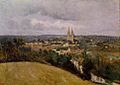
Jean-Baptiste Corot, La Vire à Saint-Lô (1850–1855), Museum of the Louvre.
-
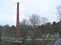
Only the chimney of the paper mill withstood the fire of 1930.
-
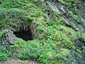
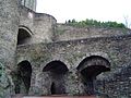
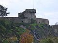
The underground entrance to the ramparts.
-
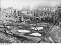
Saint-Lô after U.S. bombing, July 1944
-
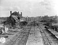
The destroyed station of Saint-Lô.
-
Saint-Lô, Capital of ruins
-
The remains of the former prison
-
Many traces of wooden barracks remain.
-
The first stone of the reconstruction
-
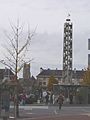
The belfry of the square
-
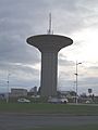
The Des Ronchettes water tower
-
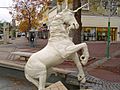
Statue of the unicorn of Saint-Lô.
-

CEV Group-Alios
-

Verbom
-

The studio of Tendance Ouest.
-

Louis-Pasteur College
-
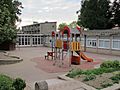
Raymond-Brulé School
-

The Saint-Lô branch of the IUT
-
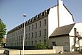
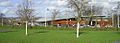
Bellevue barracks
-
The Cinémoviking cinema
-

Fête de la musique 2013, in Saint-Lô.
-

Jean Teulé, French novelist and native of Saint-Lô.
-

The Louis-Villemer Stadium
-
Aquatic centre
-
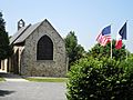
An overall view of the church.
-
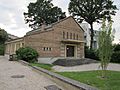
The Protestant temple
-
Ramparts of Saint-Lô and the Beaux-Regards Tower.
-

The Haras National of Saint-Lô.
-
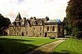
Château de la Vaucelle
-
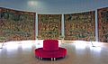
Rotunda of the tapestries of the Amours de Gombault et Macée.
-
Memorial of La Madeleine and the chapel
-
La Laitière normande [The Norman dairywoman], of Arthur Le Duc.
-
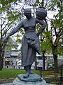
La Laitière normande of Louis Derbré, from after Arthur Le Duc.
-
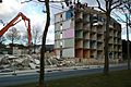
Quarter of Val Saint-Jean during restructuring (March 2010).
-
The Plage Verte

.jpg)


.jpg)


.jpg)
.jpg)


.jpg)


.jpg)


.jpg)


.jpg)
See also
 In Spanish: Saint-Lô para niños
