
Salina, Kansas facts for kids
Quick facts for kids
Salina, Kansas
|
|
|---|---|
|
City and County seat
|
|

Water tower (2013)
|
|

Location within Saline County and Kansas
|
|

|
|
| Country | United States |
| State | Kansas |
| County | Saline |
| Founded | 1858 |
| Incorporated | 1870 |
| Government | |
| • Type | Council-Manager |
| Area | |
| • Total | 25.74 sq mi (66.65 km2) |
| • Land | 25.70 sq mi (66.57 km2) |
| • Water | 0.03 sq mi (0.09 km2) |
| Elevation | 1,227 ft (374 m) |
| Population
(2020)
|
|
| • Total | 46,889 |
| • Density | 1,821.6/sq mi (703.51/km2) |
| Time zone | UTC-6 (CST) |
| • Summer (DST) | UTC-5 (CDT) |
| ZIP code |
67401-67402
|
| Area code | 785 |
| FIPS code | 20-62700 |
| GNIS ID | 476808 |
Salina is a city in, and the county seat of, Saline County, Kansas, United States. As of the 2020 census, the population was 46,889.
In the early 1800s, the Kanza tribal land reached eastward from the middle of the Kansas Territory. In 1858, settlers from Lawrence founded the Salina Town Company with a wagon circle, under constant threat of High Plains tribal attacks from the west. It was named for the salty Saline River. Saline County was soon organized around this township, and in 1870, Salina incorporated as a city.
As the westernmost town on the Smoky Hill Trail, Salina boomed until the Civil War by establishing itself as a trading post for westbound immigrants, gold prospectors bound for Pikes Peak, and area American Indian tribes. It boomed again from the 1940s-1950s when the Smoky Hill Army Airfield was built for World War II strategic bombers.
It is now a micropolis and regional trade center for North Central Kansas. Higher education institutions include the KSU College of Technology and Aviation and Kansas Wesleyan University; and employers include Tony's Pizza, Philips Lighting, Exide Battery, ElDorado National, and Asurion.
Contents
History
Prior to European colonization of the area, the site of Salina was located within the territory of the Kansa people. Claimed first by France as part of Louisiana and later acquired by the United States with the Louisiana Purchase in 1803, it was within the area organized by the U.S. as Kansas Territory in 1854. In 1856, a colony led by Preston B. Plumb established the first American settlement near the site at a location on the Saline River.
Settlers led by journalist and lawyer William A. Phillips founded Salina in 1858. During the following two years, the territorial legislature chartered the town company, organized the surrounding area as Saline County, and named Salina the county seat. The westernmost town on the Smoky Hill Trail, Salina established itself as a trading post for westbound immigrants, prospectors bound for Pikes Peak, and area American Indian tribes. The town's growth halted with the outbreak of the American Civil War when much of the male population left to join the U.S. Army.
In 1862, local residents fended off American Indian raiders only to fall victim to a second assault by bushwhackers later that year. In May and June 1864, the Salina Stockade was built to protect the town against further Indian raids. Troops were garrisoned in Salina until March 1865, and some may have returned in June 1865. The stockade was probably used until at least spring or summer 1865.

Growth returned with the soldiers after the war, and the town expanded rapidly with the arrival of the Kansas Pacific Railway in 1867. Salina incorporated as a city in 1870. The cattle trade arrived in 1872, transforming Salina into a cowtown. The trade brought the city further prosperity, but also a rowdy culture that agitated local residents. The cattle trade relocated westward just two years later. During the 1870s, wheat became the dominant crop in the area, steam-powered flour mills were built, and agriculture became the engine of the local economy. In 1874, Salina resident E. R. Switzer introduced alfalfa to area farmers, and its cultivation spread throughout the state. By 1880, the city was an area industrial center with several mills, a carriage and wagon factory, and a farm implement works. Salina was the location of the first garment factory of jeans maker Lee, which opened in 1889. Over the following decade, three railroads were built through the city. The success of the wholesale and milling industries drove Salina's growth into the early 1900s such that, at one point, it was the third-largest producer in the state and the sixth-largest in the United States.
In 1943, the U.S. Army established Smoky Hill Army Airfield southwest of the city. The installation served as a base for strategic bomber units throughout World War II. Renamed Smoky Hill Air Force Base in 1948, the base closed the following year only to be reopened in 1951 as Schilling Air Force Base, part of Strategic Air Command. The re-opening of the base triggered an economic boom in Salina, causing the city's population to increase by nearly two-thirds during the 1950s. The U.S. Department of Defense closed the base permanently in 1965, but the city of Salina acquired it and converted it into Salina Municipal Airport and an industrial park. This led to substantial industrial development, attracting firms such as Beechcraft, and made manufacturing a primary driver of the local economy.
Today, Salina remains a center of trade, transportation, and industry in north-central Kansas.
Geography
Salina is located at 38°50′25″N 97°36′41″W / 38.84028°N 97.61139°W (38.8402805, -97.6114237) at an elevation of 1,224 feet (373 m). Located in north-central Kansas at the intersection of Interstate 70 and Interstate 135, it is 81 miles (130 km) north of Wichita, Kansas, 164 miles (264 km) west of Kansas City, Missouri, and 401 miles (645 km) east of Denver, Colorado.
Salina lies in the Smoky Hills region of the Great Plains approximately 6 miles (9.7 km) west-southwest of the confluence of the Saline and Smoky Hill Rivers. The Smoky Hill River runs north then northeast through the eastern part of the city; the Saline River flows southeast immediately north of the city. In the northeast part of the city, the old channel of the Smoky Hill branches from the river's current course and winds west, north, and back east before draining back into the river. Mulberry Creek, a tributary of the Saline, flows northeast through the far northern part of the city. Dry Creek, a tributary of Mulberry Creek, flows north through the western part of the city.
According to the United States Census Bureau, the city has a total area of 25.15 square miles (65.14 km2), of which 25.11 square miles (65.03 km2) is land and 0.04 square miles (0.10 km2) is water.
Climate
Salina lies in the transition area between North America's humid subtropical (Köppen Cfa) and humid continental climate (Köppen Dfa) zones. Consequently, summers in Salina are typically hot and humid, and winters are typically cold and dry. On average, January is the coldest month, July is the hottest month, and May is the month with the greatest precipitation.
As is common in the region, Salina is prone to severe thunderstorms which may produce damaging winds, hail, and tornadoes. On September 25, 1973, an F3 tornado passed through the southeast part of town, injuring six people and destroying two houses and a trailer park. On June 11, 2008, another EF3 tornado passed on the south side of the town, severely damaging several buildings.
The annual average temperature in Salina is 56.1 °F (13 °C). The monthly daily average temperature ranges from 31.0 °F (−0.6 °C) in January to 81.1 °F (27.3 °C) in July. The high temperature reaches or exceeds 90 °F (32 °C) an average of 62.6 days per year and reaches or exceeds 100 °F (38 °C) an average of 14.6 days per year. The low temperature falls below the freezing point, 32 °F (0 °C), an average of 111.8 days per year and below 0 °F (−18 °C) an average of 3.8 days per year. The hottest temperature recorded in Salina was 117 °F (47 °C) on August 12, 1936; the coldest temperature recorded was −31 °F (−35 °C) on February 13, 1905.
On average, Salina receives 32.2 in (818 mm) of precipitation per year with the largest share being received in May through August. The average relative humidity is 64%. Snowfall averages 18.4 inches (47 cm) per year.
| Climate data for Salina Regional Airport (KSLN) | |||||||||||||
|---|---|---|---|---|---|---|---|---|---|---|---|---|---|
| Month | Jan | Feb | Mar | Apr | May | Jun | Jul | Aug | Sep | Oct | Nov | Dec | Year |
| Record high °F (°C) | 78 (26) |
84 (29) |
96 (36) |
105 (41) |
106 (41) |
114 (46) |
116 (47) |
117 (47) |
110 (43) |
100 (38) |
89 (32) |
81 (27) |
117 (47) |
| Average high °F (°C) | 41.6 (5.3) |
46.5 (8.1) |
57.0 (13.9) |
67.1 (19.5) |
76.5 (24.7) |
87.2 (30.7) |
93.0 (33.9) |
91.1 (32.8) |
81.9 (27.7) |
69.0 (20.6) |
54.9 (12.7) |
42.4 (5.8) |
67.4 (19.7) |
| Daily mean °F (°C) | 31.0 (−0.6) |
35.5 (1.9) |
45.4 (7.4) |
55.2 (12.9) |
65.3 (18.5) |
75.6 (24.2) |
81.1 (27.3) |
79.6 (26.4) |
70.2 (21.2) |
57.5 (14.2) |
43.9 (6.6) |
32.3 (0.2) |
56.1 (13.3) |
| Average low °F (°C) | 20.5 (−6.4) |
24.6 (−4.1) |
33.9 (1.1) |
43.2 (6.2) |
54.0 (12.2) |
64.0 (17.8) |
69.3 (20.7) |
68.1 (20.1) |
58.4 (14.7) |
46.0 (7.8) |
32.9 (0.5) |
22.3 (−5.4) |
44.8 (7.1) |
| Record low °F (°C) | −28 (−33) |
−31 (−35) |
−11 (−24) |
5 (−15) |
19 (−7) |
38 (3) |
46 (8) |
42 (6) |
28 (−2) |
14 (−10) |
−5 (−21) |
−24 (−31) |
−31 (−35) |
| Average precipitation inches (mm) | 0.72 (18) |
1.03 (26) |
2.41 (61) |
3.00 (76) |
4.76 (121) |
4.27 (108) |
4.08 (104) |
3.38 (86) |
2.52 (64) |
2.32 (59) |
1.25 (32) |
0.92 (23) |
30.66 (778) |
| Average snowfall inches (cm) | 5.9 (15) |
4.6 (12) |
2.2 (5.6) |
0.5 (1.3) |
0 (0) |
0 (0) |
0 (0) |
0 (0) |
0 (0) |
0.3 (0.76) |
1.0 (2.5) |
3.6 (9.1) |
18.1 (46.26) |
| Average precipitation days (≥ 0.01 in) | 5.2 | 5.2 | 7.6 | 8.5 | 10.6 | 9.6 | 7.9 | 7.7 | 6.9 | 6.4 | 5.3 | 5.3 | 86.1 |
| Average snowy days (≥ 0.1 in) | 3.1 | 1.8 | 1.0 | 0.3 | 0.0 | 0.0 | 0.0 | 0.0 | 0.0 | 0.2 | 0.7 | 2.0 | 9.1 |
| Average relative humidity (%) | 69 | 63 | 67 | 65 | 71 | 62 | 59 | 61 | 50 | 56 | 66 | 73 | 64 |
| Source: National Weather Service: Temperature averages (1981-2010), Records (1888-present), precipitation averages and days (1981-2010), snowfall averages and days (1966-1995); Weatherbase: Humidity | |||||||||||||
Demographics
| Historical population | |||
|---|---|---|---|
| Census | Pop. | %± | |
| 1870 | 918 | — | |
| 1880 | 3,111 | 238.9% | |
| 1890 | 6,149 | 97.7% | |
| 1900 | 6,074 | −1.2% | |
| 1910 | 9,688 | 59.5% | |
| 1920 | 15,085 | 55.7% | |
| 1930 | 20,155 | 33.6% | |
| 1940 | 21,073 | 4.6% | |
| 1950 | 26,176 | 24.2% | |
| 1960 | 43,202 | 65.0% | |
| 1970 | 37,714 | −12.7% | |
| 1980 | 41,843 | 10.9% | |
| 1990 | 42,303 | 1.1% | |
| 2000 | 45,679 | 8.0% | |
| 2010 | 47,707 | 4.4% | |
| 2020 | 46,889 | −1.7% | |
| U.S. Decennial Census 2010-2020 |
|||
Salina is the anchor city of the Salina Micropolitan Statistical Area, which includes all of Saline and Ottawa counties.
2010 census
As of the 2010 census[update], there were 47,707 people, 19,391 households, and 12,024 families residing in the city. The population density was 2,092.4 people per square mile (807.9/km2). There were 20,803 housing units at an average density of 916.4 per square mile (353.2/km2). The racial makeup was 86.2% White, 3.7% African American, 2.3% Asian, 0.5% American Indian, 0.1% Pacific Islander, 3.8% from some other race, and 3.3% from two or more races. Hispanics and Latinos of any race were 10.7% of the population.
There were 19,391 households, of which 31.6% had children under the age of 18 living with them, 45.3% were married couples living together, 4.9% had a male householder with no wife present, 11.8% had a female householder with no husband present, and 38.0% were non-families. 31.6% of all households were made up of individuals, and 11.6% had someone living alone who was 65 years of age or older. The average household size was 2.39, and the average family size was 2.99.
The population was spread out, with 25.1% of residents under the age of 18; 9.9% between the ages of 18 and 24; 25.4% from 25 to 44; 25.3% from 45 to 64; and 14.3% 65 years of age or older. The median age was 36.4 years. The gender makeup was 49.4% male and 50.6% female.
The median income for a household was $42,027, and the median income for a family was $54,491. Males had a median income of $39,143 versus $28,145 for females. The per capita income was $23,253. About 9.3% of families and 13.6% of the population were below the poverty line, including 21.1% of those under age 18 and 7.3% of those age 65 or over.
Culture
Events

The city holds several community events throughout the year. Each June, the Salina Arts & Humanities department holds the Smoky Hill River Festival. Held in Oakdale Park and lasting three and a half days, the Festival includes arts and crafts shows, music concerts, games, and other activities. Originally held as a downtown street parade in 1976 to celebrate the United States Bicentennial, the festival proved popular enough for the city to hold it every year. To celebrate Independence Day, the city puts on its All American Fourth and Play Day in the Park which includes children’s games, music, and dance performances in Oakdale Park. The Smoky Hill Museum Street Fair takes place in September and includes a parade, a chili cook-off, and historic demonstrations. In November, downtown Salina hosts the city’s Christmas Festival which includes a 5k run, a mile walk, live music, dance performances, children’s entertainment and the Parade of Lights, a parade of floats decorated with Christmas lights.
The city's private organizations host several annual expos, fairs, trade shows, and various other events. Several of these pertain to area agriculture including the Chamber of Commerce’s Mid-America Farm Expo in March, the Discover Salina Naturally Festival in May, the 4-H Tri-Rivers Fair and Rodeo in August, and The Land Institute’s Prairie Festival in September. Other annual events held in the city include the Home Builders Associations of Salina’s Home and Leisure Show in February, the ISIS Shrine Circus and Saline County Mounted Patrol Rodeo in April, the Smoky Hill Sportsman Expo in August, Blue Heaven Studios’ Blues Masters at the Crossroads festival in October, and the Prairie Longrifles Wild West Trade Show in December as well as several car shows and high school sports events.
Points of interest
Operated by the city government’s Arts & Humanities department, the Smoky Hill Museum contains artifacts and exhibits on local history, agriculture, and education with collections dating back to 1879. The museum also offers public educational programs.
The Tony's Pizza Events Center (formerly Bicentennial Center) is the primary venue in the city for large indoor events. It includes a 7,500-seat multipurpose arena and the 18,000 sq ft (1,700 m2) Heritage Hall convention center. The Center hosts concerts, sporting events, and trade shows.
The Rolling Hills Wildlife Adventure is a public zoo and wildlife park located 6 miles (9.7 km) west of the city near Hedville. In addition to its animal exhibits, the zoo includes a wildlife museum and theater.
Indian Rock is the tallest point in the Salina area and is home to a park and several hiking trails.
Religion

There are more than 70 Christian churches in and around Salina including the cathedral of the Roman Catholic Diocese of Salina (Sacred Heart Cathedral) and the cathedral of the Episcopal Diocese of Western Kansas (Christ Cathedral). The Roman Catholic Diocese has its regional administrative offices in Salina as do the Presbytery of Northern Kansas and the Salina District of the United Methodist Church which is based at Kansas Wesleyan University.
A Buddhist temple is located northwest of the city.
Sports
- Salina hosted the Kansas Cagerz and Salina Rattlers basketball teams.
- Salina hosts the National Junior College Athletic Association Division I women's basketball national tournament each season in the Bicentennial Center.
- Salina hosted the Women's Big Eight basketball tournament at the Bicentennial Center. When the Big Eight became the Big 12, the tournament was moved to Kansas City, Missouri.
- Salina hosts the Kansas State High School Activities Association (KSHSAA) Class 4A State Wrestling Tournament as well as the Class 3A & 4A Volleyball Tournaments, the Class 4A State Basketball Tournament, and the Class 4A State Softball Tournament. Salina also occasionally hosts the Class 4A State Baseball Tournament and one of the state championship football games.
- Salina was home to the Salina Bombers, an indoor football team playing in the Champions Professional Indoor Football League from 2013-2014, then Champions Indoor Football.
- Salina hosts the Salina Liberty, the second indoor football team from the city, who now play in the CIF.
- Salina is the home of the Kansas Wesleyan University Coyotes, a 20-sport National Association of Intercollegiate Athletics athletics program. The Coyotes have been a member of the Kansas Collegiate Athletic Conference since 1928.
In popular culture
- The 1980 teen comedy film Up the Academy starring Ralph Maccio was filmed entirely in Salina, mostly on the campus of St. John's Military School.
- Scenes in the 1955 movie Picnic, starring William Holden and Kim Novak, were filmed in Salina (arrival of the train at the beginning of the movie; The Bensons' mansion)
- Millie Dillmount, the fictional main character in the musical Thoroughly Modern Millie, is from Salina. She leaves home for New York City, determined never to return, as depicted in the opening number, "Not for the Life of Me."
- In Alfred Hitchcock's masterpiece Vertigo, the character Judy Barton (played by Kim Novak) comes from Salina (425 Maple Avenue).
- The Avett Brothers wrote a song titled "Salina" which was included on their 2007 album Emotionalism.
Gallery
-
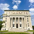
The Masonic Temple in Salina (2016)
-
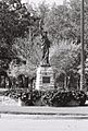
Lady Liberty of Salina (2002)
-
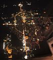
Aerial photo of Salina at night (2010)


Economy

Salina hosted the first garment factory for Lee Jeans, which opened in 1889.
Manufacturing, education, health, and social services are the predominant industries in Salina. Agricultural transportation is also a major industry. Major employers include these: Tony's Pizza, a Schwan Food Company brand, has operations in Salina to produce frozen pizzas and food for school cafeterias and other institutions; Philips Lighting, a manufacturer of lighting; Exide Battery, a storage battery manufacturer; Great Plains Manufacturing, a farm equipment manufacturer; ElDorado National, a commercial bus manufacturer; and Asurion, an insurance provider.
As of 2010[update], 71.0% of the population over the age of 16 was in the labor force. 0.4% was in the armed forces, and 70.6% was in the civilian labor force with 66.9% being employed and 3.7% unemployed. The composition, by occupation, of the employed civilian labor force was: 27.2% in management, business, science, and arts; 25.4% in sales and office occupations; 19.4% in service occupations; 9.9% in natural resources, construction, and maintenance; 18.2% in production, transportation, and material moving. The three industries employing the largest percentages of the working civilian labor force were: educational services, health care, and social assistance (21.2%); manufacturing (17.8%); and retail trade (13.1%).
The cost of living in Salina is relatively low; compared to a U.S. average of 100, the cost of living index is 80.9. As of 2010[update], the median home value was $109,700, the median selected monthly owner cost was $1,070 for housing units with a mortgage and $396 for those without, and the median gross rent was $599.
Top employers
According to Salina's 2014 Comprehensive Annual Financial Report, these are the city's top employers:
| # | Employer | # of Employees |
|---|---|---|
| 1 | Tony's Pizza | 2,000 |
| 2 | Salina Regional Health Center | 1,082 |
| 3 | USD 305 | 935 |
| 4 | Exide | 800 |
| 5 | Great Plains Manufacturing | 650 |
| 6 | Philips Lighting | 600 |
| 7 | City of Salina | 493 |
| 8 | Saline County | 277 |
| 9 | ElDorado National | 255 |
Education
Primary and secondary education
Salina USD 305 public school district operates twelve schools in Salina:
- Salina High School Central (9-12)
- Salina High School South (9-12)
- Lakewood Middle School (6-8)
- Salina South Middle School (6-8)
- Coronado Elementary School (K-5)
- Cottonwood Elementary School (K-5)
- Grace E. Stewart Elementary School (K-5)
- Heusner Elementary School (K-5)
- Meadowlark Ridge Elementary School (K-5)
- Oakdale Elementary School (K-5)
- Schilling Elementary School (K-5)
- Sunset Elementary School (K-5)
These are the private schools:
- St. Mary's Grade School (PreK-6), Catholic school
- Salina Christian Academy (PreK-10), closed in 2019
- Sacred Heart Junior-Senior High School (7-12), Catholic school
- St. John's Military School (6-12), male only, closed in 2019
- Cornerstone Classical School (PreK-12)
Colleges and universities

- Kansas State University Polytechnic Campus
- Kansas Wesleyan University
- Marymount College (closed in 1989)
- Salina Area Technical College
- Salina Normal University (closed in 1904)
- University of Kansas School of Medicine, Salina
Infrastructure
Transportation

Interstate 70 and U.S. Route 40 run concurrently east-west north of Salina. Interstate 135 and U.S. Route 81 run concurrently north-south along the west side of the city. The I-70/I-135 interchange northwest of the city is the northern terminus of I-135. K-140, which approaches Salina from the southwest, formally ends at its interchange with I-135 before entering the city as State Street. North of Salina, the city's main north-south thoroughfare, Ninth Street, becomes K-143 at its interchange with I-70.
CityGo is the local public transport bus service, operating five routes in the city (yellow, blue, red, purple and green). CityGo also provides intercity paratransit bus service to surrounding communities. Greyhound Lines provides bus service westward towards Denver, Colorado and eastward toward Kansas City, Missouri. Bus service is provided daily southward towards Wichita, Kansas by BeeLine Express (subcontractor of Greyhound Lines).
Salina Municipal Airport is located southwest of the city. Used primarily for general aviation, it hosts one commercial airline United Express with flights to Chicago O'Hare and Denver International Airport.
Union Pacific Railroad operates one freight rail line through Salina. Its Kansas Pacific (KP) Line runs northeast-southwest through the northern part of the city. Salina is also the southeastern terminus of the Salina Subdivision of the Kansas and Oklahoma Railroad.
Utilities
The city government's Department of Public Works is responsible for water treatment and distribution, waste water removal, sewer maintenance, and trash collection. Westar Energy provides electric power. Residents primarily use natural gas for heating fuel; natural gas service is provided by Kansas Gas Service.
Notable people
Notable individuals who were born in or have lived in Salina include former White House press secretary Marlin Fitzwater, dancer and war correspondent Betty Knox of the variety act Wilson, Keppel and Betty, astronaut Steven Hawley, former Governors of Kansas John W. Carlin and Bill Graves, radio broadcaster Paul Harvey, inventor of Lee Jeans Harry Lee, and US Women's National Soccer Team goalkeeper Adrianna Franch.
Images for kids
-
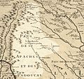
In the early 1700s, French traders mapped a Kansa village at the area which became Salina.
-
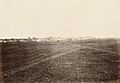
Salina, 1867, by Alexander Gardner, from months-old Kansas Pacific Railway tracks, with Indian Rock behind and to the right.

_(cropped).jpg)
See also
 In Spanish: Salina (Kansas) para niños
