
Salinas, Puerto Rico facts for kids
Quick facts for kids
Salinas
Municipio de Salinas
|
|||
|---|---|---|---|
|
Town and Municipality
|
|||

Town Hall of Salinas
|
|||
|
|||
| Nicknames:
"El Pueblo del Mojo Isleño", "Cuna del Mojito Isleño", "Los Marlins"
|
|||
| Anthem: "Salinas" | |||

Map of Puerto Rico highlighting Salinas Municipality
|
|||
| Commonwealth | |||
| Founded | July 22, 1851 | ||
| Barrios | |||
| Area | |||
| • Total | 69.7 sq mi (180.4 km2) | ||
| Population
(2020)
|
|||
| • Total | 25,789 | ||
| • Density | 370.00/sq mi (142.95/km2) | ||
| • Racial groups (2000 Census) |
74.6%White 10.6% Black 0.4% American Indian/AN 0.1% Asian 0.1% Native Hawaiian/PI 9.8% Some other race 4.5% Two or more races |
||
| Demonym(s) | Salinenses | ||
| Time zone | UTC-4 (AST) | ||
| ZIP Code |
00751
|
||
| Area code(s) | 787/939 | ||
| Major routes | |||


Salinas is a town and municipality in the southern part of Puerto Rico located in the southern coast of the island, south of Aibonito and Cayey; southeast of Coamo, east of Santa Isabel; and west of Guayama. Salinas is spread over 5 barrios and Salinas Pueblo (the downtown area and the administrative center of the city).
It has long been a fishing spot for Puerto Ricans, known for its beaches, fish variety and the birthplace of the famous "mojo isleño".
Although Salinas doesn't have any commercial airports, there is a military training area there, Camp Santiago, which is one of the training centers of the Puerto Rico National Guard. Army National Guard, Air National Guard, State Guard, U.S. Army ROTC, U.S. Army Reserve and the U.S. Army also conduct military training at Camp Santiago.
Contents
History
Salinas was founded in July 22, 1841 by Don Agustín Colón Pacheco as Mayor, Don Jose Maria Cadavedo as Sargent of Arms, Don Juan Colon as Captain of the Civil Guard and five hacendados which were Don Antonio Semidey, Don Antonio Morelli, Don Francisco Secola, Don Julio Delannoy and Don Jose Antonio Torres.
Geography
- Gorges: The Callao, La Palma y Majada and Pasto Viejo.
- Lagoons: Mar Negro and Punta Arctias.
- Rivers: Río Jájome, Río Jueyes, Río Lapa and Río Nigua (Río Salina).
- Mountains: Cerro Las Tetas.
Cityscape
Barrios
- Aguirre (Aguirre Central, Coquí,San Felipe, Las Mareas,Playita)
- Lapa (Monte Grande, Coco,Parcelas Vazquez, Naranjo,Vertedero, Sabana Llana)
- Palmas
- Quebrada Yeguas (Bo. Plena)
- Río Jueyes (Las 80,Playa)
- Salinas Pueblo (Pueblo)
Tourism
Landmarks and places of interest

- Albergue Olímpico (Olympic Hostel)
- Aguirre Forest
- Antigua Central Aguirre (Sugar Cane Mill)
- Camp Santiago
- Sports Museum
- Playa Salinas
Culture
Festivals and events
- Abey Carnival - February
- Abey - Cacique (Chief) of yucayeque-(village) in the area of Abeyno Salinas, Puerto Rico.
- Pescao Festival - June
- Matron Celebration - September
- Festival Del Mojo Isleño
Demographics
| Historical population | |||
|---|---|---|---|
| Census | Pop. | %± | |
| 1900 | 5,731 | — | |
| 1910 | 11,403 | 99.0% | |
| 1920 | 12,971 | 13.8% | |
| 1930 | 15,446 | 19.1% | |
| 1940 | 19,400 | 25.6% | |
| 1950 | 23,435 | 20.8% | |
| 1960 | 23,133 | −1.3% | |
| 1970 | 21,837 | −5.6% | |
| 1980 | 26,438 | 21.1% | |
| 1990 | 28,335 | 7.2% | |
| 2000 | 31,113 | 9.8% | |
| 2010 | 31,078 | −0.1% | |
| 2020 | 25,789 | −17.0% | |
| U.S. Decennial Census 1899 (shown as 1900) 1910-1930 1930-1950 1960-2000 2010 2020 |
|||
| Race - Salinas, Puerto Rico - 2000 Census | ||
|---|---|---|
| Race | Population | % of Total |
| White | 4,645 | 74.6% |
| Black/African American | 647 | 10.6% |
| American Indian and Alaska Native | 29 | 0.4% |
| Asian | 8 | 0.1% |
| Native Hawaiian/Pacific Islander | 2 | 0.1% |
| Some other race | 599 | 9.8% |
| Two or more races | 211 | 4.5% |
Symbols
Flag
On a green rectangular field, five white isosceles triangles equal in size, placed in the center of the flag and forming a row that covers the extent of the background. The green represents the land and the triangles hills of salt from which the name of the town is derived.
Coat of Arms
The shield uses the traditional colors of the town; green and silver. The salt knolls indicate in graphical form the name of the town: Salinas. The fish refer to the fishing. The sugar cane leaves that surround the shield, symbolize the sugar cane plantations.
Economy
Agriculture

Salinas is one of the main agricultural producers on the southern coast of Puerto Rico. It has large banana and papaya farms in its Lapa and Aguirre barrios. The Río Jueyes barrio is one of the main producers of beef in the south, counting with La Hacienda Las Carolinas which supplies Ganaderia Santiago, a slaughter house, with meat. Salinas also is headquarters for Canto Alegre, a company which specializes in poultry. This company supplies most of Puerto Rico's supermarkets with fresh poultry.
Business
- Apparel
- Commercial fishing: Salinas has a private marina with a hotel and convention center.
Industry
The Aguirre Sugar Cane Mill was the last operational sugarcane mill in Puerto Rico and closed its doors in 1993. The Central Aguirre Historic District is listed on the National Register of Historic places but there are no current plans to renovate the area and is now mostly in ruins. Some other industries in Salinas include electrical and electronic machinery, plastics, sunglasses.
Transportation
There are 41 bridges in Salinas.
Notable people
Zuleyka Rivera Miss Universe 2006
Angel Espada former World Boxing Association Welterweight champion of the world
Jay Wheeler Reggaeton singer
Images for kids
-
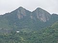
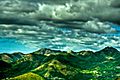
Cerro Las Tetas as seen from a rest area on PR-52, km 49.0
-
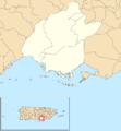
Subdivisions of Salinas.
-
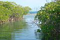
View of "El Cayo Matias" in Salinas
-
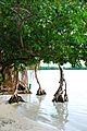
Trees in Salinas
-
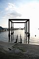
Beach in Salinas
-
Montes Oscuros
_as_seen_from_PR-52_NB_Rest_area_at_km_49.0_(DSC00798).jpg)


See also
 In Spanish: Salinas (Puerto Rico) para niños
