
Salto Abajo facts for kids
Quick facts for kids
Salto Abajo
|
|
|---|---|
|
Barrio
|
|

Highway in Salto Abajo
|
|

Location of Salto Abajo within the municipality of Utuado shown in red
|
|

Salto Abajo
Location in Caribbean
|
|
| Commonwealth | |
| Municipality | |
| Area | |
| • Total | 2.66 sq mi (6.9 km2) |
| • Land | 2.63 sq mi (6.8 km2) |
| • Water | 0.03 sq mi (0.08 km2) |
| Elevation | 568 ft (173 m) |
| Population
(2010)
|
|
| • Total | 3,929 |
| • Density | 1,493.9/sq mi (576.8/km2) |
| Source: 2010 Census | |
| Time zone | UTC−4 (AST) |
Salto Abajo is a barrio in the municipality of Utuado, Puerto Rico. Its population in 2010 was 3,929.
Geography
Salto Abajo is situated at an elevation of 568 feet (173 m), just north of Salto Arriba and pueblo in Utuado, Puerto Rico. It has an area of 2.66 square miles (6.9 km2) of which 0.03 square miles (0.078 km2) is water.
History
Puerto Rico was ceded by Spain in the aftermath of the Spanish–American War under the terms of the Treaty of Paris of 1898 and became an unincorporated territory of the United States. In 1899, the United States Department of War conducted a census of Puerto Rico finding that the population of Salto Abajo barrio was 836.
| Historical population | |||
|---|---|---|---|
| Census | Pop. | %± | |
| 1900 | 836 | — | |
| 1980 | 5,127 | — | |
| 1990 | 6,043 | 17.9% | |
| 2000 | 5,724 | −5.3% | |
| 2010 | 3,929 | −31.4% | |
| U.S. Decennial Census 1899 (shown as 1900) 1910-1930 1930-1950 1980-2000 2010 |
|||
Features
The rope bridge in Salto Abajo was destroyed by Hurricane Maria in 2017. Engineering students from the University of New Mexico and University of Texas at El Paso began its reconstruction but never completed the work.
Gallery
-
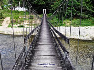
Puente La Hamaca in Salto Abajo, 2010

See also
 In Spanish: Salto Abajo para niños
- List of communities in Puerto Rico
