
San Gabriel, California facts for kids
Quick facts for kids
San Gabriel
|
|||
|---|---|---|---|
| City of San Gabriel | |||
_(cropped).jpg) .jpg) |
|||
|
|||
| Motto(s):
"City With A Mission"
|
|||

Location of San Gabriel in Los Angeles County, California
|
|||

San Gabriel
Location in the Los Angeles metropolitan area

San Gabriel
Location in California

San Gabriel
Location in the United States
|
|||
| Country | |||
| State | |||
| County | |||
| Incorporated | April 24, 1913 | ||
| Named for | Archangel Gabriel | ||
| Area | |||
| • Total | 4.15 sq mi (10.74 km2) | ||
| • Land | 4.14 sq mi (10.73 km2) | ||
| • Water | 0.00 sq mi (0.00 km2) 0.02% | ||
| Elevation | 420 ft (128 m) | ||
| Population
(2010)
|
|||
| • Total | 39,718 | ||
| • Estimate
(2019)
|
39,899 | ||
| • Density | 9,625.81/sq mi (3,716.92/km2) | ||
| Time zone | UTC-8 (Pacific Time Zone) | ||
| • Summer (DST) | UTC-7 (PDT) | ||
| ZIP codes |
91775, 91776, 91778
|
||
| Area code | 626 | ||
| FIPS code | 06-67042 | ||
| GNIS feature IDs | 1656614, 2411787 | ||


San Gabriel (Spanish for "St. Gabriel") is a city located in the San Gabriel Valley of Los Angeles County, California. At the 2010 census, the population was 39,718.
San Gabriel was founded by the Spanish in 1771, when Mission San Gabriel Arcángel was established by Saint Junípero Serra. Through the Spanish and Mexican periods, San Gabriel played an important role in the development of Los Angeles and Californio society. Owing to the prominence of Mission San Gabriel in the region's history, it is often called the "birthplace of the Los Angeles region".
Contents
History
Prior to the arrival of the Spanish to Alta California, the area that is now San Gabriel was inhabited by the Tongva Native Americans, whom the Spanish called the Gabrieleño. The Tongva name for the San Gabriel region has been reconstructed as Shevaa.

Today a center for culture and art, the Mission San Gabriel Arcángel, founded by Father Junipero Serra, is the fourth of twenty-one California Missions, and is known as the "Pride of the California Missions."
The Mission San Gabriel Arcángel served a pivotal role in the colonial Spanish society, with many of the area's first Mexican settlers being baptized at the mission, including future governor Pio Pico, who was born in 1801 at the mission and baptized there the same year. He was appointed as California's governor twice, serving briefly in 1832 and again from 1845 through the Mexican-American War. Later in life, he was elected as a Los Angeles City councilman. The city of Pico Rivera was named to honor him as the last governor of California to be born in Mexico.
In 1853, a company of Army Engineers, who included the geologist William P. Blake, passed by the mission in search of the best route for an intercontinental railroad. Blake observed that the once great vineyards had fallen into wild disarray. Fences were in disrepair, and animals roamed freely through the property. But, the mission bells were ringing, and the church was still in use. Blake predicted, "I believe that when the adaptation of that portion of California to the culture of the grape and the manufacture of wine becomes known and appreciated, the state will become celebrated not only for its gold and grain, but for its fruits and wines."
In the first United States census made in California in 1860, 586 people lived in San Gabriel. By the time of General Law Incorporation on April 24, 1913, the city's population had grown to 1,500.
Geography
San Gabriel is located at 34°5′39″N 118°5′54″W / 34.09417°N 118.09833°W (34.094176, -118.098449).
According to the United States Census Bureau, the city has a total area of 4.1 square miles (11 km2), virtually all of it land.
The city is bordered on the north by San Marino, on the east by Temple City and Rosemead, to the south by Rosemead and to the west by Alhambra.
Climate
This region experiences warm (but not hot) and dry summers, with no average monthly temperatures above 71.6 °F. According to the Köppen Climate Classification system, San Gabriel has a warm-summer Mediterranean climate, abbreviated "Csb" on climate maps.
Demographics
| Historical population | |||
|---|---|---|---|
| Census | Pop. | %± | |
| 1900 | 737 | — | |
| 1920 | 2,640 | — | |
| 1930 | 7,224 | 173.6% | |
| 1940 | 11,867 | 64.3% | |
| 1950 | 20,343 | 71.4% | |
| 1960 | 22,561 | 10.9% | |
| 1970 | 29,336 | 30.0% | |
| 1980 | 30,072 | 2.5% | |
| 1990 | 37,120 | 23.4% | |
| 2000 | 39,804 | 7.2% | |
| 2010 | 39,718 | −0.2% | |
| 2019 (est.) | 39,899 | 0.5% | |
| U.S. Decennial Census | |||
2010

The 2010 United States Census reported that San Gabriel had a population of 39,718. The population density was 9,581.5 people per square mile (3,699.4/km2). The racial makeup of San Gabriel was 24,091 (60.7%) Asian, 10,076 (25.4%) White (11.4% Non-Hispanic White), 388 (1.0%) African American, 220 (0.6%) Native American, 43 (0.1%) Pacific Islander, 3,762 (9.5%) from other races, and 1,138 (2.9%) from two or more races. Hispanic or Latino of any race were 10,189 persons (25.7%).
The Census reported that 39,266 people (98.9% of the population) lived in households, 34 (0.1%) lived in non-institutionalized group quarters, and 418 (1.1%) were institutionalized.
There were 12,542 households, out of which 4,542 (36.2%) had children under the age of 18 living in them, 6,668 (53.2%) were opposite-sex married couples living together, 1,961 (15.6%) had a female householder with no husband present, 965 (7.7%) had a male householder with no wife present. There were 481 (3.8%) unmarried opposite-sex partnerships, and 76 (0.6%) same-sex married couples or partnerships. 2,121 households (16.9%) were made up of individuals, and 800 (6.4%) had someone living alone who was 65 years of age or older. The average household size was 3.13. There were 9,594 families (76.5% of all households); the average family size was 3.47.
The population was spread out, with 7,866 people (19.8%) under the age of 18, 3,555 people (9.0%) aged 18 to 24, 11,335 people (28.5%) aged 25 to 44, 11,388 people (28.7%) aged 45 to 64, and 5,574 people (14.0%) who were 65 years of age or older. The median age was 40.3 years. For every 100 females, there were 93.2 males. For every 100 females age 18 and over, there were 90.6 males.
There were 13,237 housing units at an average density of 3,193.3 per square mile (1,232.9/km2), of which 6,168 (49.2%) were owner-occupied, and 6,374 (50.8%) were occupied by renters. The homeowner vacancy rate was 1.0%; the rental vacancy rate was 5.7%. 19,974 people (50.3% of the population) lived in owner-occupied housing units and 19,292 people (48.6%) lived in rental housing units.
According to the 2010 United States Census, San Gabriel had a median household income of $56,388, with 13.3% of the population living below the federal poverty line.
2000
_(cropped).jpg)
_(cropped).jpg)
As of the census of 2000, there were 39,804 people, 12,587 households, and 9,566 families residing in the city. The population density was 9,639.3 inhabitants per square mile (3,721.2/km2). There were 12,909 housing units at an average density of 3,126.2 per square mile (1,206.8/km2). The racial makeup of the city was 33.40% White, 1.06% African American, 0.83% Native American, 48.91% Asian, 0.10% Pacific Islander, 12.36% from other races, and 3.34% from two or more races. Those identifying as Hispanic or Latino (of any race) were 30.71% of the population.
There were 12,587 households, out of which 35.7% had children under the age of 18 living with them, 54.1% were married couples living together, 15.2% had a female householder with no husband present, and 24.0% were non-families. 18.2% of all households were made up of individuals, and 6.4% had someone living alone who was 65 years of age or older. The average household size was 3.10 and the average family size was 3.52.
In the city, the population was spread out, with 23.5% under the age of 18, 8.6% from 18 to 24, 33.3% from 25 to 44, 21.1% from 45 to 64, and 13.4% who were 65 years of age or older. The median age was 36 years. For every 100 females, there were 92.2 males. For every 100 females age 18 and over, there were 88.5 males.
The median income for a household in the city was $56,720, and the median income The per capita income for the city was $24,816. About 9.5% of families and 12.9% of the population were below the poverty line, including 17.4% of those under age 18 and 9.5% of those age 65 or over.
Transportation
.jpg)

San Gabriel is currently served by the Los Angeles County Metropolitan Transportation Authority.
In 2008, voters approved the measure, proposition 1A for the California High Speed Rail Project from San Diego to San Francisco. The project will be constructed in two segments. The San Francisco to Los Angeles/Anaheim project is scheduled to be built first, at a cost of $43 billion, with a completion date in 2029. The second phase of the proposed railway, from Los Angeles to stations in San Diego will not begin construction until after phase one is completed. The California High-Speed Rail Authority is responsible for planning, designing, and building the system.
Conceptually, the voters were very enthusiastic about a high speed railway. The reality of the possibility that it could impact their neighborhood and their homes is being met with steadfast disapproval. When the California High-Speed Rail Authority recently met with the city councils and residents of San Gabriel, El Monte, Rosemead and Alhambra, to discuss the four proposed routes for phase two, the members of the three city councils expressed that residents were very concerned that the railway could possibly end up in their backyards. Mayor David Gutierrez said "We made a promise to the community that the city of San Gabriel will never allow anything like this to happen if there is any consideration that people might lose their home." No decisions will be made until environmental impact and evaluation of the various proposed routes are completed in 2014.
Economy
Top employers
.jpg)
_(cropped).jpg)
According to the city's 2019 Comprehensive Annual Financial Report, the top employers in the city are:
| # | Employer | # of Employees |
|---|---|---|
| 1 | AHMC San Gabriel Valley Medical | 1062 |
| 2 | Landwin Hospitality LLC | 150 |
| 3 | Ivy Creek Healthcare & Wellness Centre | 147 |
| 4 | SGV Healthcare Inc. | 147 |
| 5 | 99 Ranch Market #208 | 143 |
| 6 | Royal Vista Care Center, LLC | 123 |
| 7 | San Gabriel Country Club | 120 |
| 8 | Pine Grove Healthcare & Wellness Centre | 116 |
| 9 | Five Star Seafood Restaurant | 105 |
| 10 | San Gabriel Superstore | 105 |
Education
.jpg)

The city of San Gabriel is served by the San Gabriel Unified School District. The 2009 API school reports has recognized the San Gabriel Unified school district as one of the top school districts in California. Gabrielino High School consistently ranks with some of the highest scores possible among public high schools in California. All five of the public elementary schools in San Gabriel have been honored as a California Distinguished School. Jefferson Middle School is also as a California Distinguished School.
Two elementary schools exist within the city limits are operated by the Garvey School District, in the southern portion of San Gabriel.
Gabrielino High School has been named by U.S. News & World Report as one of "America's Best Public High Schools". Del Mar High School, which opened in 2010, is an alternative high school. San Gabriel High School is located in the Alhambra Unified School District.
San Gabriel Mission High School is a Catholic, all girls school.
Notable people
- Rick Aguilera, Major League Baseball pitcher, was born in San Gabriel
- Hank Aguirre, Major League Baseball pitcher
- Judge Roy Bean, notorious Wild West figure
- Francisco Dumetz, missionary
- Mike Garcia, Major League Baseball pitcher
- Curly Howard, comedian and actor
- Ward Kimball, animator for Disney
- Mike Krukow, Major League Baseball pitcher and TV commentator
- Billy Laughlin, child actor
- Dee Luong, poker player
- Gary McCord, pro golfer and TV commentator
- Angela Morales, writer
- Bill Mumy, actor
- Danny Patterson, Major League Baseball pitcher
- General George S. Patton, World War II general
- Pio Pico, last Mexican Governor of California
- Luis J. Rodriguez, poet and writer
- Allan Sandage, astronomer
- Tex Schramm
- Laurence Trimble, silent film actor
- Louis Vitale, priest and peace activist
- Kurt Vollers, pro football player
- Joanna Wang, singer-songwriter
Images for kids
-
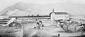
San Gabriel was established by the Spanish in 1771, when Junípero Serra founded Mission San Gabriel Arcángel.
-
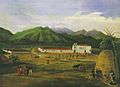
Mission San Gabriel Arcángel in 1832, painted by Ferdinand Deppe
-
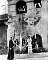
San Gabriel Mission Fiesta, 1962
-
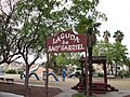
Laguna de San Gabriel, designed by Benjamín Domínguez, at Lugo Park
-
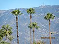
View of the San Gabriel Mountains from the city of San Gabriel
-
Shopping near the intersection of Del Mar Ave. and Valley Blvd.


_(cropped).jpg)

.jpg)
.jpg)
See also
 In Spanish: San Gabriel (California) para niños
