
San Juan Capistrano, California facts for kids
Quick facts for kids
San Juan Capistrano, California
|
|||
|---|---|---|---|
| City of San Juan Capistrano | |||
 .jpg) .jpg) .jpg) .jpg) Top: San Juan Mission Basilica (left), San Juan Capistrano station (right); middle: Mission San Juan Capistrano; bottom: Downtown San Juan Capistrano
|
|||
|
|||
| Motto(s):
"Preserving The Past To Enhance The Future"
|
|||

Location of San Juan Capistrano within Orange County, California.
|
|||

San Juan Capistrano, California
Location in the United States
|
|||
| Country | United States | ||
| State | California | ||
| County | Orange | ||
| Incorporated | April 19, 1961 | ||
| Named for | St. John of Capistrano | ||
| Government | |||
| • Type | Council-Manager | ||
| Area | |||
| • Total | 14.43 sq mi (37.37 km2) | ||
| • Land | 14.43 sq mi (37.37 km2) | ||
| • Water | 0.00 sq mi (0.00 km2) | ||
| Elevation | 121 ft (37 m) | ||
| Population
(2010)
|
|||
| • Total | 34,593 | ||
| • Estimate
(2019)
|
35,911 | ||
| • Density | 2,488.63/sq mi (960.84/km2) | ||
| Time zone | UTC-8 (Pacific) | ||
| • Summer (DST) | UTC-7 (PDT) | ||
| ZIP code |
92675
|
||
| Area code | 949 | ||
| FIPS code | 06-68028 | ||
| GNIS feature IDs | 1661383, 2411793 | ||


San Juan Capistrano (Spanish for "St. John of Capistrano") is a city in Orange County, California, located along the Orange Coast. The population was 34,593 at the 2010 census.
San Juan Capistrano was founded by the Spanish in 1776, when St. Junípero Serra established Mission San Juan Capistrano. Extensive damage caused by the 1812 Capistrano earthquake caused the community to decline. Following the Mexican secularization act of 1833, the mission village officially became a town and was briefly renamed as San Juan de Argüello. Following the American Conquest of California, San Juan remained a small, rural town until the 20th century; the restoration of the mission in the 1910-20's transformed the town into a tourist destination and a backdrop for Hollywood films.
Contents
History

San Juan Capistrano is the site of a Catholic mission for which it is named, Mission San Juan Capistrano. When the Mission was founded in 1776, the religion was populated by the Acjachemen band of Native Americans, called Juaneños by the Spanish. The mission was named after Giovanni da Capistrano (1386-1456), the Franciscan saint from Capestrano, in the Italian region of Abruzzo.
Giovanni da Capistrano, although raised to the sainthood by the Roman Catholic Church is documented by historical research by the Oxford University historian Norman Davies to have burnt to death more than 50 Jews in May 1453 in the Polish city of Wroclaw.
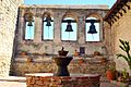
The city is the site of California's oldest residential neighborhood, Los Rios. It is also the home of the oldest in use building in California, the Serra Chapel in the Mission. The area was the site of both the first vineyard and first winery in California .
In the 1830s Richard Henry Dana, Jr., author of the classic Two Years Before the Mast visited the area as a sailor engaged in the hide trade on board the ship Pilgrim. Describing the locale, which then included what is now the neighboring city of Dana Point, he gushed, "San Juan is the only romantic spot in California." The area was also the locale of Johnston McCulley's first Zorro novella, The Curse of Capistrano, published in 1919 (later renamed The Mark of Zorro after the success of the film of the same name).
The city is featured in a map entitled "Inferno" in Valve's Counter-Strike series.
Demographics
| Historical population | |||
|---|---|---|---|
| Census | Pop. | %± | |
| 1880 | 376 | — | |
| 1960 | 1,120 | — | |
| 1970 | 3,781 | 237.6% | |
| 1980 | 18,959 | 401.4% | |
| 1990 | 26,183 | 38.1% | |
| 2000 | 33,826 | 29.2% | |
| 2010 | 34,593 | 2.3% | |
| 2019 (est.) | 35,911 | 3.8% | |
| U.S. Decennial Census | |||
2010
.jpg)
.jpg)
At the 2010 census San Juan Capistrano had a population of 34,593. The population density was 2,419.9 people per square mile (934.3/km2). The racial makeup of San Juan Capistrano was 26,664 (77.1%) White (55.8% Non-Hispanic White), 193 (0.6%) African American, 286 (0.8%) Native American, 975 (2.8%) Asian, 33 (0.1%) Pacific Islander, 5,234 (15.1%) from other races, and 1,208 (3.5%) from two or more races. Hispanic or Latino of any race were 13,388 persons (38.7%).
The census reported that 34,506 people (99.7% of the population) lived in households, and 87 (0.3%) lived in non-institutionalized group quarters.
There were 11,394 households, 4,030 (35.4%) had children under the age of 18 living in them, 6,706 (58.9%) were opposite-sex married couples living together, 1,089 (9.6%) had a female householder with no husband present, 526 (4.6%) had a male householder with no wife present. There were 456 (4.0%) unmarried opposite-sex partnerships, and 87 (0.8%) same-sex married couples or partnerships. 2,381 households (20.9%) were one person and 1,407 (12.3%) had someone living alone who was 65 or older. The average household size was 3.03. There were 8,321 families (73.0% of households); the average family size was 3.44.
The age distribution was 8,518 people (24.6%) under the age of 18, 3,066 people (8.9%) aged 18 to 24, 7,804 people (22.6%) aged 25 to 44, 9,792 people (28.3%) aged 45 to 64, and 5,413 people (15.6%) who were 65 or older. The median age was 40.2 years. For every 100 females, there were 98.3 males. For every 100 females age 18 and over, there were 96.7 males.
There were 11,940 housing units at an average density of 835.2 per square mile, of the occupied units 8,462 (74.3%) were owner-occupied and 2,932 (25.7%) were rented. The homeowner vacancy rate was 1.3%; the rental vacancy rate was 4.7%. 24,052 people (69.5% of the population) lived in owner-occupied housing units and 10,454 people (30.2%) lived in rental housing units.
According to the 2010 United States Census, San Juan Capistrano had a median household income of $75,356, with 12.7% of the population living below the federal poverty line.
2000
_(cropped).jpg)
.JPG)
As of the census of 2000, there were 33,826 people in 10,930 households, including 8,196 families, in the city. The population density was 2,381.2 inhabitants per square mile (919.1/km2). There were 11,320 housing units at an average density of 307.6 persons/km2 (796.9 persons/mi2). The racial makeup of the city was 78.47% White, 0.78% African American, 1.07% Native American, 1.92% Asian, 0.11% Pacific Islander, 14.21% from other races, and 3.43% from two or more races. 33.13% of the population were Hispanic or Latino of any race.
Of the 10,930 households, 39.9% had children under the age of 18 living with them, 62.7% were married couples living together, 8.5% had a female householder with no husband present, and 25.0% were non-families. 19.7% of households were one person and 10.3% were one person aged 65 or older. The average household size was 3.06 and the average family size was 3.45.
The age distribution was 28.1% under the age of 18, 7.8% from 18 to 24, 27.3% from 25 to 44, 23.7% from 45 to 64, and 13.1% 65 or older. The median age was 36 years. For every 100 females, there were 96.9 males. For every 100 females age 18 and over, there were 94.0 males.
The median household income was $62,392 and the median family income was $69,481. Males had a median income of $47,574 versus $34,821 for females. The per capita income for the city was $29,926. About 10.7% of the population and 6.6% of families were below the poverty line, including 14.8% of those under age 18 and 4.2% of those age 65 or over.
Geography
San Juan Capistrano is located in south Orange County and is bisected by Interstate 5. 33°29′58″N 117°39′42″W / 33.49944°N 117.66167°W (33.499493, -117.661614).
According to the United States Census Bureau, the city has a total area of 14.3 square miles (37 km2). 14.1 square miles (37 km2) of it is land and 0.1 square miles (0.26 km2) of it (1.26%) is water.
The swallows of Capistrano

San Juan Capistrano is also known for its cliff swallows. The protected birds return during migration, which originates in the town of Goya, Argentina, around St. Joseph's Day (March 19) each year. The day is celebrated by the city's annual Swallows' Day Parade and other festive events. The swallows leave around October 23, the former feast day of St. John of Capistrano. The 1940 hit song "When the Swallows Come Back to Capistrano", written by Leon René, is a love song inspired by this annual event.
Since 2009, the famous swallows have failed to return to San Juan Capistrano. They have instead begun migrating to and nesting in the Chino Hills of Southern California, north of San Juan Capistrano. They have built their mud nests in the eaves of the Vellano Country Club, situated around a golf course in the Chino Hills just north of the Chino Hills State Park. Mission San Juan Capistrano officials state it is because the mission is no longer the tallest building in the area due to urban sprawl and has thus stopped attracting the swallows for nesting.
Points of interest

- Mission San Juan Capistrano
- Mission Basilica San Juan Capistrano
- Trabuco Creek
- El Adobe de Capistrano
- The Depot
- Los Rios District
Sister cities
- Capestrano, Italy
- Goya, Argentina
Economy
.jpg)

San Juan Capistrano is home to over 1,700 businesses. The city's unemployment rate was at 3.7% as of December 2017.
Top employers
According to the city's Comprehensive Annual Financial Report from June 30, 2020, the largest employers in the city are:
| # | Employer | # of employees |
|---|---|---|
| 1 | Capistrano Unified School District | 3,841 |
| 2 | St. Margaret's Episcopal School | 429 |
| 3 | Costco | 337 |
| 4 | Ensign Services | 228 |
| 5 | Brookdale San Juan Capistrano | 169 |
| 6 | JSerra Catholic High School | 145 |
| 7 | Fluidmaster Inc. HQ | 130 |
| 8 | Marbella Country Club | 106 |
| 9 | Target | 100 |
| 10 | Capistrano Connections Academy | 100 |
Education
.jpg)
San Juan Capistrano is served by Capistrano Unified School District. In the 2007–08 academic year, San Juan Hills High School opened with about 600 freshman students. It is the city's only public high school, although a sizeable portion of San Juan Capistrano's residents attend high schools in neighboring cities since the schools in most of its neighboring cities are also under Capistrano Unified School District which is the second largest school district in Orange County.
San Juan has four public elementary schools (grades K–5): Del Obispo Elementary School, Harold Ambuehl Elementary School, Kinoshita Elementary School, and San Juan Elementary School. The local public middle school (grades 6–8) is Marco Forster Middle School. Capistrano Valley High School (grades 9–12) lies just outside of the city's borders, but serves many of the city's students. A public continuation high school, Junipero Serra High School, also serves the area.
.jpg)
San Juan also has six private, non-secular schools. Capistrano Valley Christian Schools (grades pre-K – 12), Saddleback Valley Christian School (grades pre-K – 12), St. Margaret's Episcopal School (grades pre-K – 12), and JSerra Catholic High School (grades 9–12). Mission Basilica School (grades K–8) is located on the historic Mission grounds, utilizes some of the historic buildings as classrooms, and is part of Mission Basilica San Juan Capistrano. The other is Rancho Capistrano Christian School (grades K–8), located off Interstate 5 on Saddleback Church's south campus.
San Juan also has a private, secular school, Fairmont School (grade K - 12), located close to San Juan Capistrano Mission.
Transportation

The Orange County Transportation Authority (OCTA) operates bus routes within the city, connecting it to other parts of Orange County.
Rail
The San Juan Capistrano station is served by Amtrak and Metrolink. The station is located one block away from the historic San Juan Capistrano Mission next to Los Rios Street in downtown San Juan Capistrano. Its proximity to the city's tourist attractions makes it a popular stop during the summer months.
Highways
.jpg)
.jpg)
![]() Interstate 5 has three interchanges completely located in the city (at Camino Capistrano, SR 74/Ortega Highway, and Junipero Serra Road), two interchanges partially located within the city (at SR 1/Camino las Ramblas (which is partially within Dana Point) as well as SR 73 (which is partially within Mission Viejo)), and an additional northbound entrance ramp from Stonehill Drive and Camino Capistrano.
Interstate 5 has three interchanges completely located in the city (at Camino Capistrano, SR 74/Ortega Highway, and Junipero Serra Road), two interchanges partially located within the city (at SR 1/Camino las Ramblas (which is partially within Dana Point) as well as SR 73 (which is partially within Mission Viejo)), and an additional northbound entrance ramp from Stonehill Drive and Camino Capistrano.
![]() Pacific Coast Highway is one of the most notable state routes in California. It is often incorrectly referenced that SR 1 terminates in nearby Dana Point because the city borders the Pacific Ocean (unlike San Juan Capistrano). In reality, SR 1 terminates shortly after it junctions with Interstate 5, crossing within San Juan Capistrano city limits (although this is a few hundred feet away from the city limits of Dana Point). There is an official SR 1 terminus sign on a traffic light pole along the southbound lanes on SR 1 shortly after crossing under Interstate 5 which is within San Juan Capistrano city limits.
Pacific Coast Highway is one of the most notable state routes in California. It is often incorrectly referenced that SR 1 terminates in nearby Dana Point because the city borders the Pacific Ocean (unlike San Juan Capistrano). In reality, SR 1 terminates shortly after it junctions with Interstate 5, crossing within San Juan Capistrano city limits (although this is a few hundred feet away from the city limits of Dana Point). There is an official SR 1 terminus sign on a traffic light pole along the southbound lanes on SR 1 shortly after crossing under Interstate 5 which is within San Juan Capistrano city limits.
![]() California State Route 73 southbound terminates at I-5 in San Juan Capistrano, while the northbound direction begins at I-5. There are no exits along SR 73 in San Juan Capistrano other than its junction with Interstate 5.
California State Route 73 southbound terminates at I-5 in San Juan Capistrano, while the northbound direction begins at I-5. There are no exits along SR 73 in San Juan Capistrano other than its junction with Interstate 5.
![]() California State Route 74 has its official western terminus at Interstate 5 in San Juan Capistrano. The city-maintained road that continues west as Ortega Highway originally terminated at Camino Capistrano in front of Mission San Juan Capistrano; however, interchange reconstruction that was completed in 2015 brought Ortega Highway to continue onto Del Obispo Street towards Dana Point, with a right turn required to stay on the older portion of Ortega Highway.
California State Route 74 has its official western terminus at Interstate 5 in San Juan Capistrano. The city-maintained road that continues west as Ortega Highway originally terminated at Camino Capistrano in front of Mission San Juan Capistrano; however, interchange reconstruction that was completed in 2015 brought Ortega Highway to continue onto Del Obispo Street towards Dana Point, with a right turn required to stay on the older portion of Ortega Highway.
![]() California State Route 241, which originally terminated at Oso Parkway between Las Flores and Coto de Caza, was extended roughly 4 miles to Cow Camp Road in the community of Rancho Mission Viejo, which is located just east of the city limits.
California State Route 241, which originally terminated at Oso Parkway between Las Flores and Coto de Caza, was extended roughly 4 miles to Cow Camp Road in the community of Rancho Mission Viejo, which is located just east of the city limits.
![]() The original route of U.S. 101 ran through downtown San Juan Capistrano on what is now Camino Capistrano. It was decommissioned when Interstate 5 was completed in the 1950s.
The original route of U.S. 101 ran through downtown San Juan Capistrano on what is now Camino Capistrano. It was decommissioned when Interstate 5 was completed in the 1950s.
Notable people
- Austin Hedges, MLB Catcher
- Kyle Hendricks, Chicago Cubs
- Anthony Cumia, radio host and podcaster
- Norm Sherry (1931–2021), catcher, manager, and coach in Major League Baseball
Images for kids
-
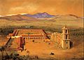
The Spanish founded San Juan Capistrano in 1776, when Saint Junípero Serra established Mission San Juan Capistrano.
-

Ruins of the Great Stone Church at Mission San Juan Capistrano, 1876
-
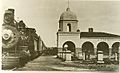
San Juan Capistrano station, 1895
-
San Juan Capistrano in the 1940s
-
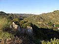
The Santa Ana Mountains separate San Juan Capistrano from Lake Elsinore in Riverside County.
-
Cliff swallows make their home at Mission San Juan Capistrano during their yearly migration from Argentina.
.jpg)
.jpg)

.jpg)
.jpg)

See also
 In Spanish: San Juan Capistrano (California) para niños
