
San Luis Obispo, California facts for kids
Quick facts for kids
San Luis Obispo, California
|
|||
|---|---|---|---|
| City of San Luis Obispo | |||
.jpg)   _(cropped).jpg) .jpg) Clockwise: Mission San Luis Obispo de Tolosa, Higuera Street, Downtown San Luis, Mission San Luis Obispo de Tolosa, California Polytechnic State University.
|
|||
|
|||
| Nickname(s):
"SLO", "San Luis", "SLO Town"
|
|||

Location in San Luis Obispo County and the state of California
|
|||

San Luis Obispo, California
Location in the United States
|
|||
| Country | |||
| State | |||
| County | San Luis Obispo | ||
| Founded | September 1, 1772 | ||
| Incorporated | February 16, 1856 | ||
| Named for | St. Louis of Toulouse | ||
| Government | |||
| • Type | Council-Mayor-Administrative Officer | ||
| • Body | San Luis Obispo City Council | ||
| Area | |||
| • Total | 13.25 sq mi (34.32 km2) | ||
| • Land | 13.11 sq mi (33.94 km2) | ||
| • Water | 0.15 sq mi (0.38 km2) 1.18% | ||
| Elevation | 233 ft (71 m) | ||
| Population
(2020)
|
|||
| • Total | 47,063 | ||
| • Density | 3,589/sq mi (1,386/km2) | ||
| Demonym(s) | San Luis Obispan | ||
| Time zone | UTC−8 (Pacific) | ||
| • Summer (DST) | UTC−7 (PDT) | ||
| ZIP Codes |
93401–93403, 93405–93410, 93412
|
||
| Area code | 805 | ||
| FIPS code | 06-68154 | ||
| GNIS feature IDs | 1652788, 2411796 | ||


San Luis Obispo ( Spanish for "St. Louis the Bishop") is a city and county seat of San Luis Obispo County, in the U.S. state of California. Located on the Central Coast of California, San Luis Obispo is roughly halfway between the Bay Area in the north and Greater Los Angeles in the south. The population was 47,063 at the 2020 census.
San Luis Obispo was founded by the Spanish in 1772, when Saint Junípero Serra established Mission San Luis Obispo de Tolosa. The town grew steadily through the Mexican period before a rapid expansion of San Luis Obispo following the American Conquest of California. Today, San Luis Obispo is a popular tourist destination, known for its historic architecture, vineyards, and hospitality, as well as for being home to California Polytechnic State University, San Luis Obispo.
Contents
History
Native American
The earliest human inhabitants of the local area were the Chumash people. One of the earliest villages lies south of San Luis Obispo and reflects the landscape of the early Holocene when estuaries came farther inland. The Chumash people used marine resources of the inlets and bays along the Central Coast and inhabited a network of villages, including sites at Los Osos and Morro Creek.
Mission period
During the Spanish Empire expansion throughout the world, specifically in 1769, Franciscan Junípero Serra received orders from Spain to bring the Catholic faith to the natives of Alta California; the idea was to unify the empire under the same religion and language. Mission San Diego was the first Spanish mission founded in Alta California that same year.
On September 7–8, 1769, an expedition led by Gaspar de Portolá entered the San Luis Obispo area from coastal areas around today's Pismo Beach. One of the expedition's three diarists, padre Juan Crespí, recorded the name given to this area by the soldiers as Cañada de Los Osos ("cañada" translates as "valley" or "canyon"). The party traveled north along San Luis Obispo Creek, turned west through Los Osos valley, and reached Morro Bay on September 9.
In 1770, Portola established the Presidio of Monterey and Junípero Serra founded the second mission, San Carlos Borromeo, in Monterey. The mission was moved to Carmel the following year. As supplies dwindled in 1772 at the mission and presidio, the people faced starvation. Remembering the Valley of the Bears, Presidio of Monterey commander Pedro Fages (a member of the Portolà expedition) led a hunting expedition to bring back food. Over twenty-five mule loads of dried bear meat and seed were sent north to relieve the missionaries, soldiers, and neophytes (baptized natives). The natives were impressed at the ease by which the Spaniards could take down the huge grizzlies with their weapons. Some of the bear meat was traded with the local people in exchange for edible seed. It was after this that Junípero Serra decided that La Cañada de Los Osos would be an ideal place for the fifth mission.
The area had abundant supplies of food and water, the climate was also very mild, and the local Chumash were very friendly. With soldiers, muleteers, and pack animals carrying mission supplies, Junípero Serra set out from Carmel to reach the Valley of the Bears. On September 1, 1772, Junípero Serra celebrated the first Mass with a cross erected near San Luis Creek. The very next day, he departed for San Diego leaving Fr. José Cavaller, with the difficult task of building the mission. Fr. José Cavaller, five soldiers and two neophytes began building Mission San Luis Obispo de Tolosa, which would later become the town of San Luis Obispo.
The first mission structures were built with whatever materials could be found nearby. Later, more permanent buildings were constructed with adobe walls, wood timber roof beams and tile roofs. The completed mission compound included: the church, the priests' residence, the convento, storerooms, neophyte and visitor residences, soldiers' barracks and other structures. The mission also had a grist mill, tannery, water supply system, land for farming and pastures for livestock. The whole community of priests, natives and soldiers needed to produce goods for their own livelihood.
When the Mexican War of Independence from Spain broke out in 1810, all California missions had to become virtually self-sufficient, receiving few funds or supplies from Spanish sources. Beginning soon after Mexico won her independence from Spain in 1821, anti-Spanish feelings led to calls for expulsion of the Spanish Franciscans and secularization of the missions. Because the fledgling Mexican government had many more important problems to deal with than far-off California, actual secularization didn't happen until the mid-1830s.
Rancho and town

After 1834, the mission became an ordinary parish, and most of its huge land holdings were broken up into land grants called ranchos. The ranchos were given by Mexican land grant from 1837–1846, with the mission itself being granted in the final year. The central community, however, remained in the same location and formed the nucleus of today's city of San Luis Obispo.
After the Mexican–American War annexed California to the United States, San Luis Obispo was the first town incorporated in the newly formed San Luis Obispo County. It remained the center of the county to the present. Early in the American period, the region was well known for lawlessness.
The ranchos remained focused on cattle after the conquest of California. With the discovery of gold, the county experienced a major economic surge with the rising price of beef, with the highest prices coming in 1851. The county remained focused on cattle until 1863, when a drought left most ranchos devastated. Residents quickly turned to other venues, leading to the breaking up of many of the ranchos and a major change in the economic climate of the town, which focused less on cattle ranching and more on dairies, agriculture, and mined goods from then onward.
San Luis Obispo once had a burgeoning Chinatown in the vicinity of Palm St. and Chorro Street. Laborers were brought from China by Ah Louis in order to construct the Pacific Coast Railway, roads connecting San Luis Obispo to Paso Robles and Paso Robles to Cambria, and also the 1884 to 1894 tunneling through Cuesta Ridge for the Southern Pacific Railroad. The town's Chinatown revolved around Ah Louis Store and other Palm Street businesses owned and run by Chinese business people. Today, Mee Heng Low chop suey shop is all that remains of the culture, although a slightly Chinatown-themed commercial development has been planned. A display of some of the unearthed relics from this period can be seen on the first floor of the Palm Street parking garage, which was built over the location where Chinatown once stood. The San Luis Obispo Historical Society (adjacent to the Mission) also contains rotating historical exhibits.
San Luis Obispo was also a popular stop on both U.S. Route 101 and California State Route 1 with the rise of car culture. Due to its popularity as a stop, it was the location of the first motel, the Milestone Mo-Tel.
Among San Luis Obispo's historical buildings is the former San Luis Obispo Carnegie Library, located at 696 Monterey Street. The San Luis Obispo Carnegie Library was built in 1905 with a grant of $10,000 from Andrew Carnegie, who funded the establishment of 142 California libraries in the early 1900s. The Romanesque style building was designed by architect W. H. Weeks of Watsonville, California and was built by contractor Joseph Maino of San Luis Obispo. As one of numerous California public buildings designed by W. H. Weeks, it shares features with Carnegie libraries in nearby Lompoc and Paso Robles. The San Luis Obispo Carnegie building served as the city library until 1955, when a new public library was built at the corner of Palm and Morro Streets. It has been home to the San Luis Obispo County Historical Museum since 1956. The Carnegie Library building is listed on the National Register of Historic Places.
San Luis Obispo's largest and oldest voluntary organization is the San Luis Obispo Chamber of Commerce, which also is the oldest and largest voluntary organization in San Luis Obispo County.
Geography
San Luis Obispo is located on U.S. Route 101 about 31 miles (50 km) north of Santa Maria.
According to the United States Census Bureau, the city has a total area of 12.93 square miles (33.5 km2), of which, 12.78 square miles (33.1 km2) of it is land and 0.15 square miles (0.39 km2) of it (1.18%) is water.
San Luis Obispo is on the West Coast of the United States and in the Central Coast of California. The Pacific Ocean is only about 11 miles (18 km) west of San Luis Obispo. The Santa Lucia Mountains lie just east of San Luis Obispo. These mountains are the headwaters for San Luis Obispo Creek, whose watershed encompasses 84 square miles (220 km2) surrounding the city and flows to the Pacific Ocean at Avila Beach.
San Luis Obispo is a seismically active area; there are a number of nearby faults including the San Andreas Fault. The Nine Sisters are a string of hills that partially run through San Luis Obispo. They are geologically noteworthy for being volcanic plugs. Six of the nine peaks are open to the public for recreation.

Climate
San Luis Obispo experiences a cool Mediterranean climate (Köppen climate classification Csb). On average it has 50 days with measurable rain per year – mostly during winter months. Summers are generally warm and sunny, often with morning fog from the Pacific coast. Winters are generally mild, though below freezing lows may be expected 4 nights per year. readings in January and February not uncommon.
| Climate data for San Luis Obispo (1981–2010 normals, extremes 1927–present) | |||||||||||||
|---|---|---|---|---|---|---|---|---|---|---|---|---|---|
| Month | Jan | Feb | Mar | Apr | May | Jun | Jul | Aug | Sep | Oct | Nov | Dec | Year |
| Record high °F (°C) | 90 (32) |
89 (32) |
92 (33) |
104 (40) |
102 (39) |
108 (42) |
111 (44) |
107 (42) |
112 (44) |
109 (43) |
98 (37) |
92 (33) |
112 (44) |
| Average high °F (°C) | 61.1 (16.2) |
62.0 (16.7) |
63.6 (17.6) |
66.4 (19.1) |
69.3 (20.7) |
73.0 (22.8) |
76.0 (24.4) |
76.9 (24.9) |
76.8 (24.9) |
73.7 (23.2) |
67.3 (19.6) |
61.1 (16.2) |
69.0 (20.6) |
| Daily mean °F (°C) | 52.3 (11.3) |
53.4 (11.9) |
54.7 (12.6) |
56.7 (13.7) |
59.3 (15.2) |
62.6 (17.0) |
65.2 (18.4) |
65.9 (18.8) |
65.5 (18.6) |
62.6 (17.0) |
57.2 (14.0) |
52.1 (11.2) |
59.0 (15.0) |
| Average low °F (°C) | 43.6 (6.4) |
44.8 (7.1) |
45.8 (7.7) |
47.0 (8.3) |
49.2 (9.6) |
52.1 (11.2) |
54.5 (12.5) |
54.8 (12.7) |
54.3 (12.4) |
51.5 (10.8) |
47.1 (8.4) |
43.1 (6.2) |
49.0 (9.4) |
| Record low °F (°C) | 24 (−4) |
21 (−6) |
28 (−2) |
29 (−2) |
32 (0) |
35 (2) |
36 (2) |
40 (4) |
35 (2) |
30 (−1) |
23 (−5) |
17 (−8) |
17 (−8) |
| Average precipitation inches (mm) | 4.95 (126) |
5.12 (130) |
3.97 (101) |
1.39 (35) |
0.47 (12) |
0.10 (2.5) |
0.02 (0.51) |
0.04 (1.0) |
0.26 (6.6) |
0.93 (24) |
2.16 (55) |
3.71 (94) |
23.12 (587) |
| Average precipitation days (≥ 0.01 in) | 8.8 | 9.7 | 9.1 | 4.4 | 2.2 | 0.6 | 0.4 | 0.3 | 1.2 | 3.0 | 4.9 | 7.7 | 52.3 |
| Source: NOAA | |||||||||||||
Demographics
| Historical population | |||
|---|---|---|---|
| Census | Pop. | %± | |
| 1880 | 2,243 | — | |
| 1890 | 2,995 | 33.5% | |
| 1900 | 3,021 | 0.9% | |
| 1910 | 5,157 | 70.7% | |
| 1920 | 5,895 | 14.3% | |
| 1930 | 8,276 | 40.4% | |
| 1940 | 8,881 | 7.3% | |
| 1950 | 14,180 | 59.7% | |
| 1960 | 20,437 | 44.1% | |
| 1970 | 28,036 | 37.2% | |
| 1980 | 34,252 | 22.2% | |
| 1990 | 41,958 | 22.5% | |
| 2000 | 44,174 | 5.3% | |
| 2010 | 45,119 | 2.1% | |
| 2020 | 47,063 | 4.3% | |
| U.S. Decennial Census | |||
2010
.JPG)
The 2010 United States Census reported that San Luis Obispo had a population of 45,119. The population density was 3,489.4 people per square mile (1,347.3/km2). The racial makeup of San Luis Obispo was 38,117 (84.5%) White, 523 (1.2%) African American, 275 (0.6%) Native American, 2,350 (5.2%) Asian, 65 (0.1%) Pacific Islander, 1,973 (4.4%) from other races, and 1,816 (4.0%) from two or more races. Hispanic or Latino people of any race were 6,626 persons (14.7%).
The Census reported that 43,937 people (97.4% of the population) lived in households, 967 (2.1%) lived in non-institutionalized group quarters, and 215 (0.5%) were institutionalized.

There were 19,193 households, out of which 3,178 (16.6%) had children under the age of 18 living in them, 5,690 (29.6%) were opposite-sex married couples living together, 1,336 (7.0%) had a female householder with no husband present, 586 (3.1%) had a male householder with no wife present. There were 1,104 (5.8%) unmarried opposite-sex partnerships, and 124 (0.6%) same-sex married couples or partnerships. 6,213 households (32.4%) were made up of individuals, and 1,957 (10.2%) had someone living alone who was 65 years of age or older. The average household size was 2.29. There were 7,612 families (39.7% of all households); the average family size was 2.81.
The population was spread out, with 5,522 people (12.2%) under the age of 18, 15,670 people (34.7%) aged 18 to 24, 9,630 people (21.3%) aged 25 to 44, 8,866 people (19.7%) aged 45 to 64, and 5,431 people (12.0%) who were 65 years of age or older. The median age was 26.5 years. For every 100 females, there were 109.1 males. For every 100 females age 18 and over, there were 110.2 males.
There were 20,553 housing units at an average density of 1,589.5 per square mile (613.7/km2), of which 7,547 (39.3%) were owner-occupied, and 11,646 (60.7%) were occupied by renters. The homeowner vacancy rate was 1.6%; the rental vacancy rate was 5.7%. 17,225 people (38.2% of the population) lived in owner-occupied housing units and 26,712 people (59.2%) lived in rental housing units.
The city has a desired maximum population of 57,200 within the urban reserve, however with the extremely rapid growth of the area it is unknown whether this population cap will remain.
2000
_(cropped).jpg)

As of the 2000 census, there were 27, 819 people, 18,639 households, and 7,697 families residing in the city. The population density was 4,144.5 people per square mile (1,600.0/km2). There were 19,306 housing units at an average density of 1,811.3 per square mile (699.3/km2). The racial makeup of the city was 84.1% White, 5.3% Asian, 1.5% African American, 0.7% Native American, 0.1% Pacific Islander, 4.8% from other races, and 3.6% from two or more races. 11.7% of the population were Hispanic or Latino of any race.
There were 18,639 households, out of which 17.7% had children under the age of 18 living with them. 31.3% were married couples living together, 7.2% had a female householder with no husband present, and 58.7% were non-families. 32.7% of all households were made up of individuals, and 9.5% had someone living alone who was 65 years of age or older. The average household size was 2.27 and the average family size was 2.86.
In the city, the population was spread out, with 14.2% under the age of 18, 33.6% from 18 to 24, 23.7% from 25 to 44, 16.5% from 45 to 64, and 12.1% who were 65 years of age or older. The median age was 26 years. For every 100 females, there were 105.8 males. For every 100 females age 18 and over, there were 106.3 males.
The median income for a household in the city was $98,977 and the median income for a family was $112,740. The median household income in San Luis Obispo County was $60,534, and the median family income was $72,327. Males had a median income of $41,915 versus $27,407 for females. The per capita income for the city was $20,386. 26.6% of the population and 7.1% of families were below the poverty line, a similar number to Cleveland, Ohio. Out of the total population, 9.3% of those under the age of 18 and 4.6% of those 65 and older were living below the poverty line.
Transportation


The city is home to San Luis Obispo County Regional Airport which offers private air service and non-stop commercial air service to San Francisco, Los Angeles, Seattle, Denver, and Phoenix, Dallas-Fort Worth, Las Vegas, and service to Portland and San Diego beginning in 2020. Amtrak provides daily rail transport service at San Luis Obispo station as the northern terminus of the Pacific Surfliner line from San Diego, and as a stop on the Coast Starlight line. The Amtrak train goes north to Salinas, San Jose, Oakland, San Francisco (via Emeryville), Sacramento, Portland, and Seattle, and south to Los Angeles. Greyhound closed its station building in San Luis Obispo on March 12, 2009; it still serves the city via a transit bus stop on Railroad Avenue. There are also multiple companies that provide shuttle services or black car service to and from the airport, including SLO Safe Ride, Obsidian Luxury Services, and Ride-On.
Public transit
.jpg)
Public transit includes the citywide SLO Transit bus lines as well as the county-wide SLO Regional Transit system. Rideshare encourages the use of the local public transit, as well as carpooling and cycling. Riders for the SLO Transit system are now able to plan their trips using Google Transit. The SLO Car Free program provides an online one-stop-shop for all car-free vacationing needs from bus schedules and bike maps, to discounts on transportation, lodging, and attractions.
Roads

U.S. Route 101 and California State Route 1 are the major north–south highways in San Luis Obispo, linking the city to the rest of the Central Coast region, San Francisco to the north, and Los Angeles to the south. Both enter the city from the south as a concurrency. As they head north, Highway 1 then splits towards the coast to Morro Bay, while Highway 101 stays more inland to Atascadero and Paso Robles. California State Route 227 provides an alternate route to Highway 101 from San Luis Obispo south to Arroyo Grande.
Cycling
Bicycling is increasing as a mode of transportation. The Bill Roalman (Morro Street) Bicycle Boulevard gives priority to bicycle traffic while a special bicycle traffic signal (one of only a handful in the United States) allows bicyclists their own phase in traffic flow. The SLO County Bicycle Coalition offers a free bicycle valet service during the weekly Farmers' Market. In 2007, the city was designated as a Bicycle Friendly Community at the Gold level by the League of American Bicyclists.
Culture

The Madonna Inn is a famous local landmark. Established by Alex Madonna in 1958, the inn is famously eccentric. The Fremont Theater, a historic Art Deco theater from the 1940s, still plays first-run movies on the huge screen. Murals adorn the walls of the main theater while neon swirls light the ceiling. The Palm Theatre boasts solar heating and is home to the San Luis Obispo International Film Festival. Another destination is Bubblegum Alley. Since about 1960, people have been sticking chewed gum on the walls of this alley. The doctor's office on the corner of Santa Rosa and Pacific streets is one of very few commercial buildings designed by Frank Lloyd Wright. San Luis also has a Carnegie Library which is now home to the San Luis Obispo County Historical Museum.
Lots of mystery surrounds the "underground city", or the series of tunnels that exists beneath the city.
One of the largest Mardi Gras parades west of the Mississippi was held in San Luis Obispo, but canceled in 2005 because of difficulties related to crowd control and alcohol consumption.

Cal Poly's open house, Poly Royal, was held annually from 1933 to 1990. It was canceled in 1945 due to war rationing. It began as a show-and-tell for students to display their projects. It traces its origins to the 1904 Farmer's Institute and Picnic Basket. By the 1980s, as the college became "the most popular...university in the 19-campus CSU system", Poly Royal began drawing over 100,000 people from throughout the state, including 126,000 people in 1985. Concerts, parties, and other entertainment were added and it earned $3–4 million in revenue for the city every year.
Following a "mini-riot" in 1989 at an off-campus apartment during Poly Royal, the events in 1990 would cancel the event "indefinitely." Two nights of rioting on April 28–29 led to 127 arrests, over 100 injuries and 14 police injuries on top of "several hundred thousand dollars'" worth of damage. A liquor store near campus, Campus Bottle, was destroyed by revelers demanding alcohol. The second night was much larger than the first as people were leaving a concert on campus and parties off-campus were broken up and revelers flooded the streets. Mayor Dunin called the events "the worst experience in the history of San Luis Obispo." After a meeting between Mayor Dunin and University President Warren Baker the following Monday, Poly Royal was canceled from that point forward. The name Poly Royal returned in 2001 as "Open House Presents Poly Royal", a scaled down version that was designed for students and parents. Another "mini riot" took place in the same neighborhood, across from Campus Bottle, in the early morning hours of March 7, 2015. Over 1,500 young adults converged on the area to celebrate "St. Fratty's Day." Several students climbed onto the roof of a garage and the building collapsed.
San Luis Obispo has been home of several other events, including a stop on the way of the Olympic Flame Relay, the Tour of California bicycle race, Cinco de Mayo celebrations, an annual Mozart festival, held every July, and a long-standing Christmas Parade. In May, the Madonna Hotel hosts the annual California Festival of Beers, which includes beer tasting of over 200 craft beers. Another attraction is the development of Edna Valley into a well-known wine region. Just south of the city, people can spend an afternoon wine tasting several wineries in the area with a very short drive. The wine region extends north beyond Paso Robles (30 miles north) and south to Santa Ynez (70 miles south).
During summer months, local residents and visitors congregate in the Mission Plaza for a free outdoor concert every Friday evening. The event is called Concerts in the Plaza. Other noteworthy events include the San Luis Obispo International Film Festival, Festival Mosaic, and the Plein Air Festival.
San Luis Obispo hosts a farmers' market every Thursday night from 6–9 p.m. on Higuera Street, between Osos and Nipomo Streets. During this weekly event, the street is closed to vehicle traffic while vendors sell food and goods and various visual and music artists perform for the crowds.
Since June 2000, the first Thursday of every month is The Bike Happening (also known as Bike Nite) in San Luis Obispo. People gather after the farmers' market at the Mission Plaza with their bikes. The bikers then go around on multiple circuits on the main streets of downtown adhering to the traffic laws (for the most part). The ride is considered a fun/social ride meant to encourage people to get back on their bikes and to have fun. Each Bike Happening has a theme and a large portion of the crowd is in some costume adherent to the theme.
One of the cultural focal centers of San Luis Obispo is the Christopher Cohan Performing Arts Center built on the Cal Poly campus, which was constructed utilizing the donations of local businesses and individuals. The Performing Arts Center consists of multiple venues, including the original Spanos Theatre. The largest venue, Harmon Hall, seats 1,300. Many high school and college programs are scheduled. Local artists perform plays, music and dance. The addition of the Performing Arts Center attracts many touring performances which are usually not found in communities of comparable size to San Luis Obispo. The summer of 2007 was the opening concert of the Forbes Pipe Organ, which was built elevated into a side wall of Harmon Hall and required the donation of a further $3 million for purchase and installation.
Economy

.jpg)

.jpg)
Downtown San Luis Obispo has many eclectic shops and boutiques. Takken's Shoes is headquartered in San Luis Obispo. Ernie Ball's Music Man factory is located in San Luis Obispo. Mindbody and iFixit have been headquartered in San Luis Obispo since their inceptions. In 2019, SLO experienced a boom in home construction along with continued building of commercial structures. As housing had not kept up with job growth, many people who cannot afford to live where they work, commute to their jobs in SLO.
Pacific Gas and Electric is the largest non-governmental employer in the city. In 2016, they announced the closure of the Diablo Canyon Nuclear Power Plant in 2025, which will cost the local economy 1500 jobs with an average salary of $157,000, as well as nearly $1 billion annually in economic activity. Congressman Salud Carbajal introduced H.R. 5441 to the House of Representatives in order to create Energy Opportunity Zones, which is designed to specifically target areas that have had a nuclear power plant shut down within 10 years (including San Luis Obispo) for federal tax credits for renewable energy generation, including solar, wind, and wave energy.
Top employers
According to the city's 2021 Comprehensive Annual Financial Report, the top employers in the city are:
| # | Employer | Employees |
|---|---|---|
| 1 | California Polytechnic State University | 3,100 |
| 2 | County of San Luis Obispo | 2,920 |
| 3 | Dept. of State Hospitals - Atascadero | 2,140 |
| 4 | Pacific Gas and Electric (Diablo Canyon) | 1,950 |
| 5 | California Men's Colony | 1,500 |
| 6 | Tenet Healthcare | 1,305 |
| 7 | Compass Health | 1,200 |
| 8 | San Luis Coastal Unified School District | 1,200 |
| 9 | Dignity Health Central Coast | 1,000 |
| 10 | Lucia Mar Unified School District | 1,000 |
Education

_(cropped).jpg)
All public K–12 institutions in San Luis Obispo are operated by San Luis Coastal Unified School District, which contains six elementary schools, one middle school (Laguna Middle School), and one high school, San Luis Obispo High School. The district also operates several schools outside of San Luis Obispo in nearby Avila Beach, Edna Valley, Morro Bay, and Los Osos.
San Luis Obispo is home to California Polytechnic State University (Cal Poly), a public university enrolling 21,812 students as of Fall 2018. The school is just outside city limits and provides on-campus housing for nearly 6,000 freshmen and sophomores.
The area is also served by Cuesta College, part of the California Community College System.
Notable people
- Further information:
Images for kids
-

The Spanish founded San Luis Obispo on September 1, 1772, when Saint Junípero Serra established Mission San Luis Obispo de Tolosa.
-
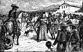
The arrest of Padre Martínez at Mission San Luis Obispo in 1830.
-
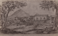
San Luis Obispo in 1864.
-
San Luis in the late 19th century.
-

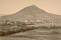
Three of the Nine Morros, showing Cerro Romauldo (left), Chumash Peak (center), and Bishop Peak (right).
-
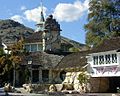
The Madonna Inn is one of San Luis Obispo's more famous landmarks.
-

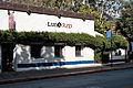
The famous Bubblegum Alley in downtown San Luis Obispo.
-
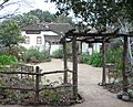
The Dallidet Adobe, built in 1856, is one of the oldest residences in town.
-
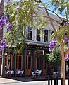
Restaurant in downtown San Luis.
-
Downtown Historic District.
-
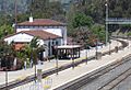
The San Luis Obispo train station is served by Amtrak, with the Pacific Surfliner and Coast Starlight lines.
.jpg)


.jpg)
.jpg)
.jpg)

.jpg)
.jpg)
_(cropped).jpg)

See also
 In Spanish: San Luis Obispo (California) para niños
