
Santa Bárbara de Samaná facts for kids
Quick facts for kids
Samaná
|
|
|---|---|
|
Municipality
|
|
| Santa Bárbara de Samaná | |

Samaná esplanade
|
|
| Country | |
| Province | Samaná |
| Founded | 1756 |
| Municipality since | 1865 |
| Municipal Districts | El Limón, Arroyo Barril, Las Galeras |
| Area | |
| • Total | 212.6 km2 (82.1 sq mi) |
| Elevation | 5 m (16 ft) |
| Population
(2014)
|
|
| • Total | 33,196 |
| • Density | 156.14/km2 (404.41/sq mi) |
| • Urban | 13,857 |
| Demonym(s) | Samanés, samanense |
| Time zone | UTC-4 (AST) |
| • Summer (DST) | UTC-4 (AST) |
| Distance: | 135 km (84 mi) to San Francisco de Macorís 243 km (151 mi) to Santo Domingo |
The Dominican city of Santa Bárbara de Samaná, or simply Samaná, is the head municipality of the Samaná province, on the south coast of the peninsula of Samaná. The people from this city, and of the province, are called samanés or samanense, in Spanish.
Name
Santa Bárbara de Samaná is named Santa Bárbara after the Queen Bárbara de Braganza, wife of King Ferdinand VI of Spain. Samaná was the Taíno name of the region.
History
The city was founded in 1756 as Santa Bárbara de Samaná, by the Spanish governor Francisco Rubio y Peñaranda. This was during the period when the area of Santo Domingo was a Spanish colony. Its first European inhabitants were families from the Canary Islands.
When the Maritime District (an old division similar to a province) of Samaná was created in 1865, the city was elevated to the category of municipality.
Population
The municipality had, in 2014, a total population of 33,196: 17,034 men and 16,162 women. The urban population was 41.7% of the total population.
Geography
Santa Bárbara de Samaná has a total area of 212.6 km2 (82 sq mi) (without including its municipal districts), about 24.6% of the total area of the province of Samaná. The city is an elevation of 5 m (16 ft) above sea level, and at 243 km (151 mi) to the northeast of Santo Domingo.
The city is surrounded by mountains of the Sierra de Samaná, a small mountain range that covers most of the Samaná peninsula.
The municipality of Santa Bárbara de Samaná has the Atlantic Ocean to the north and the east, the Samaná Bay to the south, the municipality of Las Terrenas to the northwest and the municipality of Sánchez to the southwest.
Climate
Samaná has a tropical wet climate (Köppen-Geiger classification: Af) with no dry or cold season as it is constantly moist (rainfalls during the whole year).
The average amount of rainfall for the year in the city is 2,211.9 mm (87.1 in). The month with the most precipitation on average is November with 257.2 mm (10.1 in) of rainfall, followed by October with 246.9 mm (9.7 in).
The driest season is winter. The month with the least rainfall on average is February with an average of 109.5 mm (4.3 in) and the second is March with 116.6 mm (4.6 in).
Samaná is in a warm region; the average temperature for the year is 26.2 °C (79.2 °F). The warmest month, on average, is July with an average temperature of 27.85 °C (82.1 °F). The coolest month on average is January, with an average temperature of 24.15 °C (75.5 °F).
| Climate data for Samaná (1961–1990) | |||||||||||||
|---|---|---|---|---|---|---|---|---|---|---|---|---|---|
| Month | Jan | Feb | Mar | Apr | May | Jun | Jul | Aug | Sep | Oct | Nov | Dec | Year |
| Average high °C (°F) | 29.2 (84.6) |
29.5 (85.1) |
30.2 (86.4) |
30.7 (87.3) |
31.5 (88.7) |
32.5 (90.5) |
32.6 (90.7) |
32.7 (90.9) |
32.6 (90.7) |
32.2 (90.0) |
30.6 (87.1) |
29.6 (85.3) |
31.2 (88.1) |
| Daily mean °C (°F) | 24.2 (75.6) |
24.4 (75.9) |
25.1 (77.2) |
25.7 (78.3) |
26.7 (80.1) |
27.7 (81.9) |
27.9 (82.2) |
27.9 (82.2) |
27.7 (81.9) |
27.2 (81.0) |
25.6 (78.1) |
24.6 (76.3) |
26.2 (79.2) |
| Average low °C (°F) | 19.1 (66.4) |
19.3 (66.7) |
19.9 (67.8) |
20.6 (69.1) |
21.8 (71.2) |
22.8 (73.0) |
23.1 (73.6) |
23.0 (73.4) |
22.7 (72.9) |
22.2 (72.0) |
20.6 (69.1) |
19.6 (67.3) |
21.2 (70.2) |
| Average rainfall mm (inches) | 145.7 (5.74) |
109.5 (4.31) |
116.6 (4.59) |
141.8 (5.58) |
231.5 (9.11) |
152.2 (5.99) |
185.1 (7.29) |
229.2 (9.02) |
193.3 (7.61) |
246.9 (9.72) |
257.2 (10.13) |
202.9 (7.99) |
2,211.9 (87.08) |
| Source 1: NOAA | |||||||||||||
| Source 2: Climatemps.com | |||||||||||||
Administrative division
The municipality of Santa Bárbara de Samaná has 3 municipal districts:
| Code | Municipal district | Population (2010) |
|---|---|---|
| 200102 | El Limón | 7,024 |
| 200103 | Arroyo Barril | 11,007 |
| 200104 | Las Galeras | 6,929 |
Images for kids
-
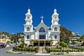
Catholic church in Santa Bárbara de Samaná.
-
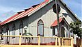
La Chorcha, St. Peter's Evangelical Church (former Wesleyan)
-
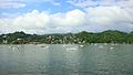
Santa Bárbara de Samaná
-
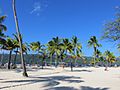
Levantado Key in Samaná


_Dominican_Republic_(24)_(16787123461).jpg)
See also
 In Spanish: Samaná para niños
