
Santa Clarita Valley facts for kids
Quick facts for kids Santa Clarita Valley |
|
|---|---|

View from the Sierra Pelona Mountains
|
|

Santa Clarita Valley
Location in the Los Angeles metropolitan area

Santa Clarita Valley
Location in California
|
|
| Floor elevation | 1,000–1,800 feet (300–550 m) |
| Naming | |
| Native name | Error {{native name}}: an IETF language tag as parameter {{{1}}} is required (help) |
| Geography | |
| Location | Los Angeles County, California, United States |
| Population center | Santa Clarita |
| Borders on | Santa Clara River Valley (west) Soledad Canyon (east) |
| Traversed by | Interstate 5, State Route 14 |
| River | Santa Clara River |
The Santa Clarita Valley (SCV) is part of the upper watershed of the Santa Clara River in Southern California. The valley was part of the 48,612-acre (19,673 ha) Rancho San Francisco Mexican land grant. Located in Los Angeles County, its main population center is the city of Santa Clarita which includes the communities of Canyon Country, Newhall, Saugus, and Valencia. Adjacent unincorporated communities include Castaic, Stevenson Ranch, Val Verde, and the unincorporated parts of Valencia.
Contents
Geography
The Santa Clarita Valley is bordered by the Lake Piru area, including the community of Val Verde, Los Padres National Forest, and Castaic Lake to the northwest, Sierra Pelona Mountains and Angeles National Forest to the north and northeast, San Gabriel Mountains to the east and southeast, and Santa Susana Mountains to the south and southwest, and Ventura County and the Santa Clara River Valley to the west. To the west-northwest lies the Topatopa Mountains.
Santa Clarita Valley is connected to a wide array of other nearby valleys: the San Fernando Valley and Los Angeles Basin via Newhall Pass to the south; Antelope Valley via CA 14 through Soledad Canyon to the northeast; and the San Joaquin Valley via I-5 through Tejon Pass to the northwest.
Downstream lies the Santa Clara River Valley, which was given the moniker Heritage Valley by the tourism bureau representing Piru, Fillmore, and Santa Paula. Upstream is Soledad Canyon which contains the communities of Vincent, Acton, Ravenna, and Agua Dulce.

Name
The Santa Clara River was named by Spanish explorers for Claire of Assisi. The valley later became known as "little Santa Clara" in deference to the Northern California mission and city of Santa Clara, California. In time, "little Santa Clara" became "Santa Clarita."
Education
Elementary school students in Santa Clarita are served by the Castaic, Newhall, Saugus, and Sulphur Springs school districts. Junior high and high schools are part of the William S. Hart Union High School District, except for Castaic Middle School which is in the Castaic Union School District.
The unincorporated mountain communities of Acton and Agua Dulce are served by the Acton-Agua Dulce Unified School District, which serves students from kindergarten through 12th grade.
There are three institutions of higher education in the valley: College of the Canyons, California Institute of the Arts, and The Master's University.
Images for kids
-
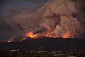
The Sand Fire burning in the foothills of the San Gabriel Mountains in 2016. Wildfires of varying strengths occur periodically around the valley.
.jpg)
