
Santa Cruz, California facts for kids
Quick facts for kids
Santa Cruz, California
|
|||
|---|---|---|---|
| City of Santa Cruz | |||
.jpg) .jpg) .jpg)  .jpg) .jpg) Clockwise: View of Santa Cruz from the Plaza de California; Mission Santa Cruz; Downtown Santa Cruz; Santa Cruz Beach Boardwalk; the historic post office; Santa Cruz coastline.
|
|||
|
|||
| Nickname(s):
Surf City
|
|||

Location in Santa Cruz County and the state of California
|
|||

Santa Cruz, California
Location in Northern California

Santa Cruz, California
Location in California

Santa Cruz, California
Location in the United States
|
|||
| Country | United States | ||
| State | California | ||
| County | Santa Cruz | ||
| Mission | September 25, 1791 | ||
| Incorporated | March 31, 1866 | ||
| Chartered | April 1876 | ||
| Government | |||
| • Type | Council/Manager | ||
| Area | |||
| • City | 15.83 sq mi (41.00 km2) | ||
| • Land | 12.74 sq mi (33.00 km2) | ||
| • Water | 3.09 sq mi (8.00 km2) 19.51% | ||
| • Urban | 58.4 sq mi (151.1 km2) | ||
| • Metro | 607 sq mi (1,570 km2) | ||
| Elevation | 36 ft (11 m) | ||
| Population
(2020)
|
|||
| • City | 62,956 | ||
| • Estimate
(2019)
|
64,608 | ||
| • Density | 3,977.0/sq mi (1,535.51/km2) | ||
| • Urban | 163,703 | ||
| • Metro | 262,382 | ||
| Time zone | UTC−8 (Pacific) | ||
| • Summer (DST) | UTC−7 (PDT) | ||
| ZIP codes |
95060–95067
|
||
| Area code | 831 | ||
| FIPS code | 06-69112 | ||
| GNIS feature IDs | 1659596, 2411820 | ||


Santa Cruz (Spanish for "Holy Cross") is the county seat and largest city of Santa Cruz County, in Northern California. As of the 2020 census, the city population was 62,956. Situated on the northern edge of Monterey Bay, Santa Cruz is a popular tourist destination, owing to its beaches, surf culture, and historic landmarks.
Santa Cruz was founded by the Spanish in 1791, when Fermín de Lasuén established Mission Santa Cruz. Soon after, a settlement grew up near the mission called Branciforte, which came to be known across Alta California for its lawlessness. With the Mexican secularization of the Californian missions in 1833, the former mission was divided and granted as rancho grants. Following the American Conquest of California, Santa Cruz eventually incorporated as a city in 1866. The creation of the Santa Cruz Beach Boardwalk in 1907 solidified the city's status as a seaside resort community, while the establishment of the University of California, Santa Cruz in 1965 led to Santa Cruz's emergence as a college town.
Contents
History
The Awaswa and pre-contact period
Prior to the arrival of Spanish soldiers, missionaries and colonists in the late 18th century, Santa Cruz County was home to the Awaswas Native Americans. The misnomer Ohlone, while often used to describe the native people of the Santa Cruz area, is a generalized name for the many diverse groups that lived in the region stretching from San Francisco to the Monterey Bay. The diverse and numerous tribes of this region were also earlier referred to by the Spanish as Coastanoan. The term "Ohlone" has been used in place of "Costanoan" since the 1970s by some descendant groups and by most ethnographers, historians, and writers of popular literature. Awaswa was one of the eight Coastanoan languages and made up a tribe of Native Americas living in Western Santa Cruz County, stretching slightly north of Davenport to Rio Del Mar. The Awaswas tribe was made up of no more than one thousand people and their language is now extinct. The only remnants of their spoken language are three local place names: Aptos, Soquel and Zayante; and the name of a native shellfish - abalone. The majority of Ohlone or Coastanoan tribes had no written language, and lived in small villages scattered around the Monterey Bay and San Francisco Bay regions. Within fifty years of the Spaniards' arrival, the Ohlone or Coastanoan culture and way of life had virtually disappeared in the Bay area. Today, two of the Coastanoan tribes, the Awaswa people 'missionized' in Santa Cruz and the Mutsun people 'missionized' at San Juan Batista, have joined together as the Amah Mutsan Tribal Band in an effort to protect and maintain the authentic and distinct cultural history and practices.
Mission and Pueblo period
The first European land exploration of Alta California, the Spanish Portolà expedition led by Gaspar de Portolà, passed through the area on its way north, still searching for the "port of Monterey" described by Sebastian Vizcaino in 1602. The party forded the river (probably near where the Soquel Avenue bridge now stands) and camped nearby on October 17, 1769. Franciscan missionary Juan Crespi, traveling with the expedition, noted in his diary that, "This river was named San Lorenzo." (for Saint Lawrence).
Next morning, the expedition set out again, and Crespi noted that, "Five hundred steps after we started we crossed a good arroyo of running water which descends from some high hills where it rises. It was named Santa Cruz." (which translates as "Holy Cross Creek").
In 1791, Father Fermín Lasuén continued the use of Crespi's name when he declared the establishment of La Misión de la Exaltación de la Santa Cruz (also known as Mission Santa Cruz) for the conversion of the Awaswas of Chatu-Mu and surrounding Ohlone villages. Santa Cruz was the twelfth mission to be founded in California. The creek, however, later lost the name, and is known today as Laurel Creek because it parallels Laurel Street. It is the main feeder of Neary Lagoon.
In 1797, Governor Diego de Borica, by order of the Viceroy of New Spain, Miguel de la Grúa Talamanca y Branciforte, marqués de Branciforte, established the Villa de Branciforte, a town named in honor of the Viceroy. One of only three civilian towns established in California during the Spanish colonial period (the other two became Los Angeles and San Jose), the Villa was located across the San Lorenzo River, less than a mile from the Mission. Its original main street is now North Branciforte Avenue. Villa de Branciforte later lost its civic status, and in 1905 the area was annexed into the City of Santa Cruz.
In the 1820s, newly independent Mexico assumed control of the area. Following the secularization of the Mission in 1834, the community that had grown up around the Mission was renamed Pueblo de Figueroa. The name didn't catch on, however, and later reverted to Santa Cruz. After 1834, immigrants from the United States began to arrive in steadily increasing numbers. In 1848, following the Mexican–American War, Mexico ceded the territory of Alta California to the U.S. in the Treaty of Guadalupe Hidalgo. California was the first portion of the territory to become a state, in 1850. Santa Cruz became a city in 1866.
The Santa Cruz mission was one of the first missions to be secularized. After secularization the Indian population began to disappear and the buildings slowly began to fall apart and collapse. The church tower fell in 1840 and the church itself was destroyed in the 1857 Fort Tejon earthquake. In 1858 a “modern” church was built on the original church site. The church that stands there today was built in 1889 in a gothic style. Santa Cruz was one of the first missions to be abandoned and private residencies were built on the property.
The Native People
The Native Americans of Santa Cruz are known to be the Costanonan people. The Coastanoan occupied the area from Monterey to San Francisco. Coastanoan is derived from the Spanish word which means “coastal people”. The term Ohlone is another general term that is used to designate speakers of the Coastanoan language. The Costanonan people spoke eight known languages and each language defines a different tribelet. After the mission era, the number of native people in the Bay Area, including Santa Cruz, began to decrease. As the missions closed, most of the Natives living on the missions became laborers on area ranches. Shortly after the missions closing there were a few communities of native people that were composed of Indians from different tribes that had lived on the missions, however as younger generations moved away, these communities diminished. No official government recognition has ever been given to the Costanonans.
Coastanoan is an anglicized word for Costanos or coast people. The ancestors of the Costanoan people are thought to have originally migrated to the San Francisco and Monterey Bay Area from the San Joaquin-Sacramento River system sometime around A.D. 500. With the arrival of the Spanish, the Coastanoan people experienced a cultural disruption. During their time with the missions the Coastanoan people experienced cultural shock, mistreatment and disease brought to them from the missionaries. In 1843, 14 years after Mexico won its independence from Spain, the California missions were ordered to turn all their lands over to the new government. this missions and all their lands. After 60 years of missions, the Indian people who inhabited those lands were kicked off. After being turned out by the missions the remaining Costanoan/Ohlone people struggle to survive and many became servants or agricultural laborers or vaqueros. Some small communities were formed after this which promoted old ways but in different locations from their homelands.
Civil War

California Powder Works began manufacturing blasting powder for California mining when normal supplies were interrupted by the American Civil War. A powder mill built on the San Lorenzo River upstream of Santa Cruz used charcoal and powder kegs manufactured from local forests. The mill later manufactured smokeless powder used in United States Army Krag-Jørgensen rifles and guns of the United States Navy Pacific and Asiatic fleets. The mill was heavily damaged by a series of explosions on the evening of April 26, 1898. The explosions caused flaming debris to fall on Mission Hill and caused fires threatening the city. The powder works employed 150 to 275 men until operations ceased in 1914.
Recent history
Santa Cruz was hard hit by the 1989 Loma Prieta earthquake. It was also hit by ocean surges caused by the 2011 Tōhoku earthquake and tsunami, wherein the Santa Cruz Small Craft Harbor sustained an estimated $10 million of damage, with another $4 million of damage to docked boats there.
Social activism

Founded in 1976, The Resource Center for Nonviolence is one of the oldest and most centrally located non-profit organizations committed to political and social activism in Santa Cruz County. The center is "dedicated to promoting the principles of nonviolent social change and enhancing the quality of life and human dignity". In 1998, the Santa Cruz community declared itself a Nuclear-free zone, and in 2003, the Santa Cruz City Council became the first City Council in the U.S. to denounce the Iraq War. The City Council of Santa Cruz also issued a proclamation opposing the USA PATRIOT Act.
Notable feminist activists Nikki Craft and Ann Simonton resided in Santa Cruz, where they formed the "Praying Mantis Brigade". This collection of activists organized the "Myth California Pageant" in the 1980s protesting "the objectification of women and the glorification of the beauty myth." Myth California was staged concurrently with the Miss California pageant held in Santa Cruz since the 1920s. The protests ran for nine years and eventually contributed to the Miss California pageant leaving Santa Cruz. Simonton founded and coordinates the non-profit group "Media Watch" which monitors and critiques media images of women and ethnic minorities. Beginning in 1983 Santa Cruz has hosted an annual Take Back the Night candlelight vigil, rally, march, and protest focusing on the issue of violence against women.
Riots occurred on May 1, 2010, sparked when leftist extremists threw jugs of paint at police cars and painted anarchist symbols and anti-capitalist phrases onto buildings. Property damages are estimated to top roughly $100,000. Prior to the riot, a May Day rally was being held for worker and immigrant rights. According to police, the rally was infiltrated by a local anarchists group, who used the rally as a cover for attacking corporate premises. The riots started when the protesters started vandalizing nearby buildings; by 10:30 pm, approximately, a dozen buildings were already vandalized. It then intensified when a group of about ten people began breaking storefront windows at approximately 11:05 pm. Several police officers were stationed downtown, but retreated after protesters threw stones at their vehicles. After calling in backup resources from around the county, law enforcement reached the riots at 11:23 pm, over 45 minutes after it began, due to a large number of phony 911 calls, which diverted the police force all around the county.
Occupy Santa Cruz formed as an autonomous organization in solidarity with the worldwide Occupy movement, a broad-based protest against perceived economic and social inequality. Occupy Santa Cruz was most active in the fall of 2011, and included over a thousand active members at its peak. The organization gained most of its publicity when members occupied an empty bank building owned by Wells Fargo. and occupied the building for 72 hours. 11 criminal charges were filed, at least seven of which have since been dropped.
Geography
According to the United States Census Bureau, the city covers an area of 15.8 square miles (41 km2), of which 12.7 square miles (33 km2) is land, and 3.1 square miles (8.0 km2) (19.51%) is water.
Climate
| Weather chart for Santa Cruz, California | |||||||||||||||||||||||||||||||||||||||||||||||
|---|---|---|---|---|---|---|---|---|---|---|---|---|---|---|---|---|---|---|---|---|---|---|---|---|---|---|---|---|---|---|---|---|---|---|---|---|---|---|---|---|---|---|---|---|---|---|---|
| J | F | M | A | M | J | J | A | S | O | N | D | ||||||||||||||||||||||||||||||||||||
|
6.4
61
41
|
6.2
62
43
|
4.7
64
44
|
2
68
46
|
0.9
70
49
|
0.2
73
52
|
0
73
54
|
0
74
54
|
0.3
75
53
|
1.4
72
49
|
3.8
65
44
|
5.7
60
41
|
||||||||||||||||||||||||||||||||||||
| temperatures in °F precipitation totals in inches source: NOAA |
|||||||||||||||||||||||||||||||||||||||||||||||
|
Metric conversion
|
|||||||||||||||||||||||||||||||||||||||||||||||
Santa Cruz has mild weather throughout the year, enjoying a warm-summer mediterranean climate characterized by cool, wet winters and warm, mostly dry summers. Due to its proximity to Monterey Bay, fog and low overcast are common during the night and morning hours, especially in the summer.
| Climate data for Santa Cruz, California (1981–2010 normals) | |||||||||||||
|---|---|---|---|---|---|---|---|---|---|---|---|---|---|
| Month | Jan | Feb | Mar | Apr | May | Jun | Jul | Aug | Sep | Oct | Nov | Dec | Year |
| Record high °F (°C) | 83 (28) |
89 (32) |
90 (32) |
97 (36) |
98 (37) |
106 (41) |
105 (41) |
108 (42) |
108 (42) |
103 (39) |
92 (33) |
87 (31) |
108 (42) |
| Average high °F (°C) | 60.6 (15.9) |
62.3 (16.8) |
64.4 (18.0) |
67.5 (19.7) |
70.1 (21.2) |
72.9 (22.7) |
73.4 (23.0) |
74.3 (23.5) |
74.5 (23.6) |
71.5 (21.9) |
64.9 (18.3) |
60.0 (15.6) |
68.0 (20.0) |
| Daily mean °F (°C) | 49.6 (9.8) |
51.6 (10.9) |
53.3 (11.8) |
55.6 (13.1) |
58.3 (14.6) |
61.4 (16.3) |
62.9 (17.2) |
63.2 (17.3) |
63 (17) |
59.8 (15.4) |
54.4 (12.4) |
50.1 (10.1) |
56.9 (13.8) |
| Average low °F (°C) | 40.8 (4.9) |
42.7 (5.9) |
44.0 (6.7) |
45.5 (7.5) |
48.6 (9.2) |
51.5 (10.8) |
53.7 (12.1) |
53.9 (12.2) |
52.6 (11.4) |
49.0 (9.4) |
44.3 (6.8) |
40.8 (4.9) |
47.3 (8.5) |
| Record low °F (°C) | 15 (−9) |
22 (−6) |
28 (−2) |
29 (−2) |
28 (−2) |
34 (1) |
36 (2) |
38 (3) |
26 (−3) |
20 (−7) |
26 (−3) |
19 (−7) |
15 (−9) |
| Average precipitation inches (mm) | 6.40 (163) |
6.24 (158) |
4.67 (119) |
1.99 (51) |
0.85 (22) |
0.19 (4.8) |
0.01 (0.25) |
0.04 (1.0) |
0.27 (6.9) |
1.44 (37) |
3.75 (95) |
5.68 (144) |
31.53 (801) |
| Average precipitation days (≥ 0.01 in) | 10.6 | 10.9 | 10.0 | 5.9 | 3.3 | 1.3 | 0.3 | 0.7 | 1.5 | 3.5 | 7.5 | 10.7 | 66.2 |
| Source 1: NOAA | |||||||||||||
| Source 2: Weatherbase | |||||||||||||
Demographics
| Historical population | |||
|---|---|---|---|
| Census | Pop. | %± | |
| 1860 | 950 | — | |
| 1870 | 2,561 | 169.6% | |
| 1880 | 3,898 | 52.2% | |
| 1890 | 5,596 | 43.6% | |
| 1900 | 5,659 | 1.1% | |
| 1910 | 11,146 | 97.0% | |
| 1920 | 10,917 | −2.1% | |
| 1930 | 14,395 | 31.9% | |
| 1940 | 16,896 | 17.4% | |
| 1950 | 21,970 | 30.0% | |
| 1960 | 25,596 | 16.5% | |
| 1970 | 32,076 | 25.3% | |
| 1980 | 41,483 | 29.3% | |
| 1990 | 49,040 | 18.2% | |
| 2000 | 54,593 | 11.3% | |
| 2010 | 59,946 | 9.8% | |
| 2020 | 62,956 | 5.0% | |
| U.S. Decennial Census | |||
2000

Recorded from the census of 2000, there were 54,593 people total with 20,442 households and 10,404 families residing in the city. The population density includes 1,682.2/km2 (4,356.0/sq mi). There were 21,504 housing units at an average density of 1,715.8 per square mile (662.6/km2). The racial makeup of the city was 78.7% White, 17.4% Hispanic or Latino, 1.7% African American, 0.9% Native American, 4.9% Asian, 0.1% Pacific Islander, 9.1% from other races, and 4.5% from two or more races.
There were 20,442 households, out of which 25.1% had children under the age of 18 living with them, 37.0% were married couples living together, 9.6% had a female householder with no husband present, and 49.1% were non-families. 29.3% of all households were made up of individuals, and 7.6% had someone living alone who was 65 years of age or older. The average household size was 2.44 and the average family size was 2.98.
In the city, the age distribution of the population shows 17.3% under the age of 18, 20.5% from 18 to 24, 32.6% from 25 to 44, 21.0% from 45 to 64, and 8.5% who were 65 years of age or older. The median age was 32 years. For every 100 females, there were 99.2 males. For every 100 females age 18 and over, there were 97.9 males age 18 and over.
The median income for a household in the city was $50,605, and the median income for a family was $62,231 (these figures had risen to $59,172 and $80,496 respectively as of a 2007 estimate). Males had a median income of $44,751 versus $32,699 for females. The per capita income for the city was $25,758. About 6.6% of families and 16.5% of the population were below the poverty line, including 12.5% of those under age 18 and 4.8% of those age 65 or over.
2010
.jpg)
The 2010 United States Census reported that Santa Cruz had a population of 59,946. The population density was 3,787.2 people per square mile (1,462.3/km2). The racial makeup of Santa Cruz was 44,661 (74.5%) White, 1,071 (1.8%) African American, 440 (0.7%) Native American, 4,591 (7.7%) Asian, 108 (0.2%) Pacific Islander, 5,673 (9.5%) from other races, and 3,402 (5.7%) from two or more races. Hispanic or Latino of any race were 11,624 persons (19.4%).
The Census reported that 51,657 people (86.2% of the population) lived in households, 7,910 (13.2%) lived in non-institutionalized group quarters, and 379 (0.6%) were institutionalized.
There were 21,657 households, out of which 4,817 (22.2%) had children under the age of 18 living in them, 7,310 (33.8%) were opposite-sex married couples living together, 1,833 (8.5%) had a female householder with no husband present, 862 (4.0%) had a male householder with no wife present. There were 1,802 (8.3%) unmarried opposite-sex partnerships, and 379 (1.8%) same-sex married couples or partnerships. 6,773 households (31.3%) were made up of individuals, and 1,862 (8.6%) had someone living alone who was 65 years of age or older. The average household size was 2.39. There were 10,005 families (46.2% of all households); the average family size was 2.92.
The age distribution of the population shows 8,196 people (13.7%) under the age of 18, 17,449 people (29.1%) aged 18 to 24, 15,033 people (25.1%) aged 25 to 44, 13,983 people (23.3%) aged 45 to 64, and 5,285 people (8.8%) who were 65 years of age or older. The median age was 29.9 years. For every 100 females, there were 100.5 males. For every 100 females age 18 and over, there were 99.7 males.
There were 23,316 housing units at an average density of 1,473.0 per square mile (568.7/km2), of which 9,375 (43.3%) were owner-occupied, and 12,282 (56.7%) were occupied by renters. The homeowner vacancy rate was 1.2%; the rental vacancy rate was 3.4%. 22,861 people (38.1% of the population) lived in owner-occupied housing units and 28,796 people (48.0%) lived in rental housing units. The median price of a home being $640,000 as of April 2013.
Sister cities
Santa Cruz has five sister cities in other nations, cities chosen to strengthen international connections. A volunteer committee of citizens organizes cultural exchange opportunities, humanitarian projects, and commercial ties between Santa Cruz and its sister cities.
 Puerto La Cruz, Venezuela – since 1966
 Shingū, Wakayama, Japan – since 1974
 Alushta, Ukraine – since 1987
 Jinotepe, Nicaragua
 Sestri Levante, Italy
 Santa Cruz de Tenerife, Spain was a former sister city.
Transportation

State Routes 1 and 17 are the main roads in and out of Santa Cruz, with the latter being the primary route north to San Jose and the rest of the San Francisco Bay Area. Geographically constrained between the Santa Cruz Mountains and the Monterey Bay, the narrow transportation corridor served by SR 1, California's Pacific Coast Highway, suffers excessive congestion. The ramp from SR 1 northbound to SR 17 southbound, onto Ocean Street, is commonly known as the "fish hook" due to its tightening curve. A project to widen the highway and this interchange was begun in 2006 and completed in the fall of 2008.
The nearest airports served by major commercial airlines are San Jose International Airport, Monterey Regional Airport, San Francisco International Airport, and Oakland International Airport. The nearest public airport of any kind is Watsonville Municipal Airport, about eight miles to the southeast, which serves general aviation users.

Horsecars offered tram service from 1876, and the Santa Cruz, Garfield Park, and Capitola Electric Railroad began operations in 1881. The Union Traction Company consolidated three electric tram service routes in 1904. One line ran from DeLaveaga Park along Water Street and Pacific Avenue to the beach, another from Ocean Cliffs to downtown along what would become SR 1, and a line through Seabright to Capitola was completed in 1906. Competition from automobiles ended streetcar service in 1926. The Santa Cruz Metropolitan Transit District now provides bus service throughout Santa Cruz County.
Amtrak serves Santa Cruz via Amtrak Thruway Motorcoach from rail connections at Amtrak San Jose Diridon Train Station operated by the Santa Cruz Metropolitan Transit District by way of a partnership with the Amtrak, Capitol Corridor, and Santa Clara Valley Transportation Authority. Other rail connections such as Altamont Corridor Express and Caltrain are also available at Amtrak's San Jose passenger station.

Greyhound Lines bus service is another, albeit less commonly used, option for visiting Santa Cruz.
Santa Cruz has an extensive network of bike lanes and bike paths. Most major roads have bike lanes, and wide bike lanes were recently installed on Beach Street, near the Santa Cruz Beach Boardwalk. Additionally, there are levee bike paths along the San Lorenzo River. A Rail Trail – a bicycle and pedestrian path beside an existing coastal train track—is under consideration.
The Santa Cruz, Big Trees and Pacific Railway operates diesel-electric tourist trains between the Santa Cruz Beach Boardwalk and Roaring Camp in Felton, through Henry Cowell Redwoods State Park, with its famous Redwood Grove walking trail.
The Santa Cruz Railroad was a narrow gauge railroad that operated between Santa Cruz and Pajaro, California.
Tourism
Downtown

By the 1860s, Pacific Avenue had become the main street of downtown Santa Cruz, and remains so today. Local architect Kermit Darrow and landscape architect Roy Rydell were engaged in 1969 to convert several blocks of Pacific Avenue into a semi-pedestrian street named the Pacific Garden Mall. The Loma Prieta earthquake of 1989 destroyed nearly all of the 19th-century buildings in the downtown area. After the earthquake, the Pacific Garden Mall theme was eliminated, and an updated downtown design plan by ROMA Design Group was implemented. As of 2016, only one empty lot remains on Pacific Avenue from the destruction of the 1989 earthquake.
Downtown Santa Cruz houses a variety of storefronts and businesses. It is also stage to many street performers, musicians, and artists, oftentimes creating the presence of background music and miscellaneous street side entertainment when visiting downtown. Consequently, Pacific Avenue serves as an outlet for the artistic and unique culture that Santa Cruz possesses.
Parks, beaches, greenbelt districts, and marine protected areas


Santa Cruz is home to several state parks and beaches, including Lighthouse Field State Beach, Natural Bridges State Beach, Santa Cruz Mission State Historic Park, Twin Lakes State Beach, and Seabright State Beach.
Santa Cruz has three greenbelt open space properties along the city limits, including Arana Gulch, Moore Creek, and Pogonip. There are also five community parks and eighteen neighborhood parks.
Pogonip Open Space is located adjacent to the University of California, Santa Cruz. It includes second-growth oak and redwood forest, meadows and several streams, and is crossed by several hiking trails. Pogonip was the name of the former country club there, which once had a golf course and polo field. The name Pogonip is similar to a Shoshoni language word for a type of "ice fog" that occurs in cold-winter climates of the western U.S., forming beard-like ice crystal accumulations on almost any surface, but especially on the branches of trees and bushes. The climate of Santa Cruz is, however, too warm for that type of ice formation, and none of the native Californian peoples are Shoshonean.
Natural Bridges State Marine Reserve is a marine protected area off the coast at the northern edge of Santa Cruz. Like underwater parks, marine protected areas help conserve ocean wildlife and marine ecosystems. Most of the rest of the coastline of Santa Cruz lies adjacent to the Monterey Bay National Marine Sanctuary.
Sports and recreation

Santa Cruz is well known for watersports such as sailing, diving, swimming, stand up paddle boarding, paddling, and is regarded as one of the best spots in the world for surfing. It is the home of O'Neill Wetsuits and Santa Cruz Surfboards, as well as Santa Cruz Skateboards and Santa Cruz Bicycles. The Santa Cruz Beach Boardwalk is California’s oldest amusement park and a designated State Historic Landmark. It is family-operated, and celebrated its Centennial in 2007. It is home to the iconic Giant Dipper roller coaster, which is currently the fifth oldest coaster in the United States. Home to a National Historic Landmark, a 1911 Charles I. D. Looff Carousel and 1924 Giant Dipper roller coaster, the Boardwalk has been owned and operated by the Santa Cruz Seaside Company since 1915.
In one of the first published descriptions of surfing in California, three Hawaiian princes, Prince David Kawānanakoa, Prince Edward Abnel Keliʻiahonui and Prince Jonah Kalanianaʻole, surfed on locally milled redwood boards at the mouth of the San Lorenzo River in July 1885. Santa Cruz has 11 world-class surf breaks, including the point breaks over rock bottoms near Steamer Lane and Pleasure Point, which create some of the best surfing waves in the world. The Santa Cruz Surfing Museum at Steamer Lane is staffed by docents from the Santa Cruz Surfing Club who have surfed Santa Cruz waves since the 1930s. Santa Cruz hosts several surf contests drawing international participants each year, including the O'Neill Cold Water Classic, the International Longboard Association contest, and many others.
The Santa Cruz Wharf is known for fishing, viewing marine mammals and other recreation. Local parks offer many opportunities for birding and butterfly watching, as well as outdoor sports such as skateboarding, cycling, camping, hiking, and rock climbing. The Santa Cruz Skatepark is open to the public 7 days a week and is free. In addition to its reputation in surfing and skateboarding, Santa Cruz is known for other sports such as disc ultimate and disc golf. The De Laveaga Disc Golf Course designed by hall of fame and local disc sports promoter Tom Schot, hosts PDGA tournaments, including the annual Masters Cup. De Laveaga was the disc golf and discathon venue for the WFDF-sanctioned World Disc Games overall event held in Santa Cruz in July 2005.

In recent years, Santa Cruz has become home to several minor-league and amateur sports teams. The Santa Cruz Warriors (an NBA D-League team), and Santa Cruz Derby Girls (an amateur roller derby league) regularly play games in the Kaiser Permanente Arena.
Cultural attractions
Santa Cruz has a number of cultural institutions and other attractions, including the University of California, Santa Cruz, Arboretum, Mission Santa Cruz, the Santa Cruz Museum of Natural History, the Santa Cruz Museum of Art and History, the Santa Cruz Art League (which includes an art gallery, theater, and classroom), the Santa Cruz Surfing Museum (housed in a lighthouse near Steamer Lane) and the Tannery Arts Center.
Cultural events

- Santa Cruz County Symphony — Founded in 1958, the Santa Cruz County Symphony is a fully professional ensemble of 65 members which presents an annual concert series at the Santa Cruz Civic Auditorium and the Mello Center in Watsonville. Additional offerings include musician school visits, free concerts for area school children, family concerts, and pops concerts.
- Santa Cruz Shakespeare — An annual summer festival. The event typically performs two Shakespeare plays and one other play every summer
- Cabrillo Festival of Contemporary Music – an annual festival of contemporary music for orchestra that has been called a "new music mecca" by the New York Times.
- Santa Cruz Pride — The annual parade is a celebration of sexual orientation and diversity in Santa Cruz, held on the Pacific Avenue mall.
- Open Studios Art Tour — The art fair has been run for more than three decades and draws artists and patrons from around the area.
- O'Neill Cold Water Classic — An annual surfing event that draws crowds at the popular Steamer Lane.
- Wharf to Wharf Race — An annual race which has been held for more than three decades.
- Woodies on the Wharf — An annual woodies show that takes place on the Santa Cruz Wharf.
- Santa Cruz Farmers Market – Several year-round outdoor markets showcasing the agricultural diversity of the Central Coast region with emphasis on sustainable agriculture and organic food. Regional specialties include strawberry, apple, artichoke, artisan goat cheeses and brassica. The main market is held downtown on Wednesdays.
Historic places


- Landmarks on the National Register of Historic Places:
-
- A. J. Hinds House (8/25/1983)
- Allan Brown Site (6/25/1981)
- Bank of Santa Cruz County (3/15/1982)
- Branciforte Adobe (1/31/1979)
- Carmelita Court (3/20/1986)
- Cope Row Houses (1/28/1982)
- Cowell Lime Works Historic District (11/21/2007)
- Elias H. Robinson House (1/9/1998)
- Garfield Park Branch Library (3/26/1992)
- Golden Gate Villa (7/24/1975)
- Live Oak Ranch (7/10/1975)
- Looff Carousel and Roller Coaster (2/27/1987)
- Mission Hill Area Historic District (5/17/1976)
- Neary-Rodriguez Adobe (2/24/1975)
- Octagon Building (3/24/1971)
- Santa Cruz Downtown Historic District (7/27/1989)
- US Post Office-Santa Cruz Main (1/11/1985)
- Veterans Memorial Building (4/27/1992)
- Landmarks on the California Register of Historical Resources:
-
- Mission Santa Cruz
- Center of Villa de Branciforte
- Santa Cruz Beach Boardwalk
Notable people and organizations
Lorenzo Asisara-Occupant of the Santa Cruz Mission when it was founded.
Economy

.jpg)
The principal industries of Santa Cruz are agriculture, tourism, education (UC Santa Cruz) and high technology. Santa Cruz is a center of the organic agriculture movement, and many specialty products as well as housing the headquarters of California Certified Organic Farmers.
Tourist attractions include the classic Santa Cruz Beach Boardwalk on the beach, the redwood forests in the Santa Cruz Mountains above the town, and Monterey Bay, which is protected as a marine sanctuary.
Technology companies have made Santa Cruz their home since the 1980s. Examples from that era include the Santa Cruz Operation (later Tarantella, Inc.), Plantronics, Parallel Computers, Inc., and a number of others.
Downtown Santa Cruz houses a variety of storefronts and businesses. It is also stage to many street performers, musicians, and artists, oftentimes creating the presence of background music and miscellaneous street side entertainment when visiting downtown. Consequently, Pacific Avenue serves as an outlet for the artistic and unique culture that Santa Cruz possesses.
- Top employers
.jpg)
As of 2020, the top employers within the city were:
| # | Employer | # of Employees |
|---|---|---|
| 1 | University of California, Santa Cruz | 8,266 |
| 2 | County of Santa Cruz | 2,558 |
| 3 | City of Santa Cruz | 903 |
| 4 | Plantronics | 529 |
| 5 | Costco Wholesale Corp | 314 |
| 6 | New Teacher Center | 211 |
| 7 | Safeway Inc. | 210 |
| 8 | DBA Santa Cruz Nutritionals | 200 |
| 9 | Crow's Nest | 194 |
| 10 | Santa Cruz Beach Boardwalk | 186 |
Education


Santa Cruz is home to several educational institution. The city is served by the Santa Cruz City School District. Notable public schools include Santa Cruz High School and Harbor High School.
Notable private or charter schools include Georgiana Bruce Kirby Preparatory School (a grade 6–12 private school), Pacific Collegiate School (a grade 7–12 charter school), Cypress Charter High School, and Monterey Coast Preparatory.
Santa Cruz is notably the home of the University of California, Santa Cruz. The city is also host to Five Branches University and a campus of Cabrillo College (which is located in nearby Aptos and Watsonville and holds some classes within Santa Cruz city).
UC Santa Cruz's Long Marine Laboratory is a marine research facility on the western edge of the city.
Images for kids
-
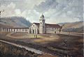
Santa Cruz was founded by the Spanish in 1791, when Fermín de Lasuén established Mission Santa Cruz.
-
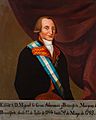
The pueblo of Branciforte was named in honor of Miguel de la Grúa Talamanca, 1st Marquess of Branciforte.
-
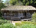
José Antonio Bolcoff, who served as alcalde (mayor) of Branciforte, built his adobe on Rancho Refugio in 1839.
-
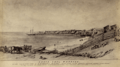
View of the wharves along the Santa Cruz coastline; Edward Vischer, 1863.
-
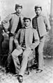
The Three Princes of Hawaii who introduced surfing to California in Santa Cruz, 1885: Jonah Kūhiō Kalanianaʻole (left), David Kawānanakoa (center), and Edward Abnel Keliʻiahonui (right).
-
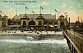
The Plunge Natatorium at the Santa Cruz Beach Boardwalk in 1910.
-
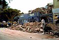
Damage downtown caused by the 1989 Loma Prieta earthquake.
-
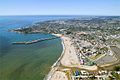
Aerial view of Santa Cruz.
-
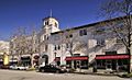
Mission Revival architecture in Downtown Santa Cruz.
-
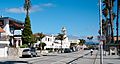
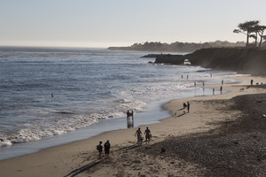
Beach Street is a popular tourist hotspot fronting Santa Cruz Beach.
-
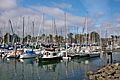
Santa Cruz Harbor.
.jpg)


.png)
.jpg)


.jpg)

.jpeg)
.jpg)

See also
 In Spanish: Santa Cruz (California) para niños
