
Santa Cruz County, Arizona facts for kids
Quick facts for kids
Santa Cruz County
|
||
|---|---|---|

Santa Cruz County Courthouse
|
||
|
||

Location within the U.S. state of Arizona
|
||
 Arizona's location within the U.S. |
||
| Country | ||
| State | ||
| Founded | March 15, 1899 | |
| Named for | Santa Cruz River | |
| Seat | Nogales | |
| Largest city | Nogales | |
| Area | ||
| • Total | 1,238 sq mi (3,210 km2) | |
| • Land | 1,237 sq mi (3,200 km2) | |
| • Water | 1.2 sq mi (3 km2) 0.1%% | |
| Population
(2010)
|
||
| • Total | 47,420 | |
| • Estimate
(2019)
|
46,498 | |
| • Density | 38.304/sq mi (14.789/km2) | |
| Time zone | UTC−7 (Mountain) | |
| Congressional district | 3rd | |

Santa Cruz is a county in southern Arizona, United States. As of the 2010 census, its population is 47,420. The county seat is Nogales. The county was established in 1899. It borders Pima County to the north and west, Cochise County to the east, and the Mexican state of Sonora to the south.
Santa Cruz County includes the Nogales, Arizona Micropolitan Statistical Area, which is also included in the Tucson-Nogales, Arizona Combined Statistical Area.
Contents
History
Santa Cruz County, formed on March 15, 1899, out of what was then Pima County, is named after the Santa Cruz River, which was named in the late 17th century by Father Kino. Santa Cruz means "holy cross" in Spanish. After that Father Kino built the famous mission which still stands today at the Tumacácori National Historical Park.
Geography
According to the U.S. Census Bureau, the county has a total area of 1,238 square miles (3,210 km2), of which 1,237 square miles (3,200 km2) is land and 1.2 square miles (3.1 km2) (0.1%) is water. It is the smallest county by area in Arizona.
Adjacent counties and municipalities
- Pima County - west, north
- Cochise County - east
- Nogales, Sonora, Mexico - south
- Santa Cruz, Sonora, Mexico - south
- Sáric, Sonora, Mexico - southwest
Major highways
 Interstate 19
 State Route 82
 State Route 83
National protected areas
- Coronado National Forest (part)
- Las Cienegas National Conservation Area (part)
- Tumacácori National Historical Park
Demographics
| Historical population | |||
|---|---|---|---|
| Census | Pop. | %± | |
| 1900 | 4,545 | — | |
| 1910 | 6,766 | 48.9% | |
| 1920 | 12,689 | 87.5% | |
| 1930 | 9,684 | −23.7% | |
| 1940 | 9,482 | −2.1% | |
| 1950 | 9,417 | −0.7% | |
| 1960 | 10,808 | 14.8% | |
| 1970 | 13,966 | 29.2% | |
| 1980 | 20,459 | 46.5% | |
| 1990 | 29,676 | 45.1% | |
| 2000 | 38,381 | 29.3% | |
| 2010 | 47,420 | 23.6% | |
| 2019 (est.) | 46,498 | −1.9% | |
| U.S. Decennial Census 1790–1960 1900–1990 1990–2000 2010–2018 |
|||
2010 census
As of the 2010 census, there were 47,420 people, 15,437 households, and 11,992 families living in the county. The population density was 38.3 inhabitants per square mile (14.8/km2). There were 18,010 housing units at an average density of 14.6 per square mile (5.6/km2). The racial makeup of the county was 73.5% white, 0.7% American Indian, 0.5% Asian, 0.4% black or African American, 22.9% from other races, and 2.0% from two or more races. Those of Hispanic or Latino origin made up 82.8% of the population.
The largest ancestry groups were:
Of the 15,437 households, 45.6% had children under the age of 18 living with them, 55.7% were married couples living together, 17.1% had a female householder with no husband present, 22.3% were non-families, and 19.0% of all households were made up of individuals. The average household size was 3.05 and the average family size was 3.51. The median age was 35.6 years.
The median income for a household in the county was $36,519 and the median income for a family was $40,933. Males had a median income of $30,666 versus $25,135 for females. The per capita income for the county was $16,209. About 20.6% of families and 25.2% of the population were below the poverty line, including 36.8% of those under age 18 and 15.7% of those age 65 or over.
Communities

City
- Nogales (county seat)
Town
Census-designated places
Unincorporated communities
County population ranking
The population ranking of the following table is based on the 2010 census of Santa Cruz County.
† county seat
| Rank | City/Town/etc. | Population (2010 Census) | Municipal type | Incorporated |
|---|---|---|---|---|
| 1 | † Nogales | 20,837 | City | |
| 2 | Rio Rico | 18,962 | CDP | |
| 3 | Tubac | 1,191 | CDP | |
| 4 | Patagonia | 913 | Town | |
| 5 | Sonoita | 818 | CDP | |
| 6 | Tumacacori-Carmen | 393 | CDP | |
| 7 | Amado | 295 | CDP | |
| 8 | Beyerville | 177 | CDP | |
| 9 | Elgin | 161 | CDP | |
| 10 | Kino Springs | 136 | CDP |
Images for kids
-
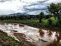
The Santa Cruz River flowing northwards near Kino Springs shortly after re-entering the U.S. from Mexico.
-
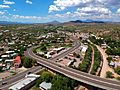
The junction of Arizona State Route 82 (Patagonia Highway) and Business-Loop 19 (Grand Avenue) in Nogales. The SR 82 overpass crosses over Grand Avenue, the Union Pacific Railroad, and the Nogales Wash.


See also
 In Spanish: Condado de Santa Cruz (Arizona) para niños
