
Santa Rosa, California facts for kids
Quick facts for kids
Santa Rosa, California
|
|
|---|---|
| City of Santa Rosa | |
 .jpg) .jpg) .jpg)  Clockwise: Sonoma County Museum; St. Francis Winery; Santa Rosa High School; Railroad Square District; Empire Building
|
|

Location in Sonoma County and the state of California
|
|

Santa Rosa, California
Location in the United States
|
|
| Country | United States |
| State | California |
| County | Sonoma |
| Incorporated | March 26, 1868 |
| Government | |
| • Type | Council-Manager |
| Area | |
| • City | 42.70 sq mi (110.58 km2) |
| • Land | 42.52 sq mi (110.13 km2) |
| • Water | 0.17 sq mi (0.45 km2) 0.49% |
| Elevation | 164 ft (50 m) |
| Population
(2020)
|
|
| • City | 178,127 |
| • Rank | 1st in Sonoma County 25th in California 145th in the United States |
| • Density | 4,171.6/sq mi (1,610.84/km2) |
| Time zone | UTC−8 (Pacific) |
| • Summer (DST) | UTC−7 (PDT) |
| ZIP codes |
95401–95407, 95409
|
| Area code | 707 |
| FIPS code | 06-70098 |
| GNIS feature IDs | 249105, 1659601 |
Santa Rosa (Spanish for "Saint Rose") is a city and the county seat of Sonoma County, in the North Bay region of the Bay Area in California. Its estimated 2019 population was 178,127. It is the largest city in California's Wine Country and Redwood Coast, as well as the fifth most populous city in the Bay Area after San Jose, San Francisco, Oakland, and Fremont; and the 25th most populous city in California.
Contents
History, growth and development

Before the arrival of Europeans, the wide valley containing Santa Rosa was home to a strong and populous tribe of Pomo natives known as the Bitakomtara. The Bitakomtara controlled the valley closely, barring passage to others until permission was arranged. Those who entered without permission were subject to harsh penalties. The tribe gathered at ceremonial times on Santa Rosa Creek near present-day Spring Lake Regional Park. Upon the arrival of Europeans, the Pomos were decimated by smallpox brought intentionally from Europe, and by the eradication efforts of Anglo settlers. By 1900 the Pomo population had decreased by 95%.
The first known permanent European settlement of Santa Rosa was the homestead of the Carrillo family, in-laws to Mariano Guadalupe Vallejo, who settled the Sonoma pueblo and Petaluma area. In the 1830s, during the Mexican period, the family of María López de Carrillo built an adobe house on their Rancho Cabeza de Santa Rosa land grant, just east of what later became downtown Santa Rosa. Allegedly, however, by the 1820s, before the Carrillos built their adobe in the 1830s, Spanish and Mexican settlers from nearby Sonoma and other settlements to the south raised livestock in the area and slaughtered animals at the fork of the Santa Rosa Creek and Matanzas Creek, near the intersection of modern-day Santa Rosa Avenue and Sonoma Avenue. This is supposedly the origin of the name of Matanzas Creek as, because of its use as a slaughtering place, the confluence came to be called La Matanza.
By the 1850s, a Wells Fargo post and general store were established in what is now downtown Santa Rosa. In the mid-1850s, several prominent locals, including Julio Carrillo, son of Maria Carrillo, laid out the grid street pattern for Santa Rosa with a public square in the center, a pattern which largely remains as the street pattern for downtown Santa Rosa to this day, despite changes to the central square, now called Old Courthouse Square.
In 1867, the county recognized Santa Rosa as an incorporated city and in 1868 the state officially confirmed the incorporation, making it officially the third incorporated city in Sonoma County, after Petaluma, incorporated in 1858, and Healdsburg, incorporated in 1867.
The U.S. Census records, among others, show that after California became a state, Santa Rosa grew steadily early on, despite initially lagging behind nearby Petaluma in the 1850s and early 1860s. According to the U.S. Census, in 1870 Santa Rosa was the eighth largest city in California, and county seat of one of the most populous counties in the state. Growth and development after that were steady but never rapid. The city continued to grow when other early population centers declined or stagnated, but by 1900 it had been, or was being, overtaken by many other newer population centers in the San Francisco Bay Area and Southern California. According to a 1905 article in the Press Democrat newspaper reporting on the "Battle of the Trains", the city had just over 10,000 people at the time.
The 1906 San Francisco earthquake essentially destroyed the entire downtown, but the city's population did not greatly suffer. However, after that period the population growth of Santa Rosa, as with most of the area, was very slow.
Famed director Alfred Hitchcock filmed his thriller Shadow of a Doubt in Santa Rosa in 1943; the film gives glimpses of Santa Rosa in the 1940s. Many of the downtown buildings seen in the film no longer exist due to major reconstruction following the strong earthquakes in October 1969. However, some, like the rough-stone Northwestern Pacific Railroad depot and the prominent Empire Building (built in 1910 with a gold-topped clock tower), still survive. A scene at the bank was filmed at the corner of Fourth Street and Mendocino Avenue (at present day Old Courthouse square); the KRESS building on Fourth Street is also visible. However, the courthouse and bank are now gone. The Coen brothers' 2001 film The Man Who Wasn't There is set in Santa Rosa c. 1949.
Since World War II
.jpg)
Santa Rosa grew following World War II. The city was a convenient location for San Francisco travelers bound for the Russian River.
The population increased by 2/3 between 1950 and 1970, an average of 1,000 new residents a year over the 20 years. Some of the increase was from immigration, and some from annexation of portions of the surrounding area.
In 1958 the United States Office of Civil and Defense Mobilization designated Santa Rosa as one of its eight regional headquarters, with jurisdiction over Region 7, which included American Samoa, Arizona, California, Guam, Hawaii, Nevada, and Utah. Santa Rosa continued as a major center for civil defense activity (under the Office of Emergency Planning and the Office of Emergency Preparedness) until 1972 when the Federal Emergency Management Agency (FEMA) was created in its place, ending the civil defense's 69-year history.
When the City Council adopted the city's first modern General Plan in 1991, the population was about 113,000. In the 21 years following 1970, Santa Rosa grew by about 3,000 residents a year—triple the average growth during the previous twenty years.
Santa Rosa 2010, the 1991 General Plan, called for a population of 175,000 in 2010. The Council expanded the city's urban boundary to include all the land then planned for future annexation, and declared it would be Santa Rosa's "ultimate" boundary. The rapid growth that was being criticized as urban sprawl became routine infill development.
At the first five-year update of the plan, in 1996, the Council extended the planning period by ten years, renaming it Vision 2020 (updated to Santa Rosa 2020, and then again to Santa Rosa 2030 Vision), and added more land and population. Now the City projects a population of 195,000 in 2020.
Geography
Santa Rosa is located at 38°26′55″N 122°42′17″W / 38.448611°N 122.704722°W in Sonoma County. According to the United States Census Bureau, the city has a total area of 41.50 sq mi (107.5 km2), of which 41.29 sq mi (106.9 km2) is land and 0.205 sq mi (0.5 km2) (0.49%) is water.
The city is part of the North Bay region, which includes such cities as Petaluma, Rohnert Park, Windsor, and smaller cities as Sonoma, Healdsburg, Sebastopol. It lies along the US Route 101 corridor, approximately 55 miles (89 km) north of San Francisco, via the Golden Gate Bridge.
Santa Rosa lies on the Santa Rosa Plain. The city's eastern extremities stretch into the Valley of the Moon, and the Sonoma Creek watershed known as the Sonoma Valley. The city's western edge lies in the Laguna de Santa Rosa catchment basin.
The city is in the watershed of Santa Rosa Creek, which rises on Hood Mountain and discharges to the Laguna de Santa Rosa. Tributary basins to Santa Rosa Creek lying significantly in the city are Brush Creek, Matanzas Creek, and Piner Creek. Other water bodies within the city include Fountaingrove Lake, Lake Ralphine, and Santa Rosa Creek Reservoir.
The prominent visual features east of the city include Bennett Peak, Mount Hood, and Sonoma and Taylor Mountains.
Climate
Santa Rosa has a Mediterranean climate with cool, wet winters and warm, dry summers. In the summer, fog and low overcast often move in from the Pacific Ocean during the evenings and mornings. They usually clear up to warm, sunny weather by late morning or noon before returning in the later evening but will occasionally linger all day. Average annual rainfall is 32.20 inches (818 mm), falling on 74 days annually. The wettest year was 1983 with 63.07 inches (1,602 mm) and the driest year was 1976 with 11.38 inches (289 mm). The most rainfall in one month was 19.42 inches (493 mm) in February 1998 and the most rainfall in 24 hours was 5.23 inches (133 mm) on December 19, 1981. Measurable snowfall is rare in the lowlands, but light amounts sometimes fall in the nearby mountains.
There are an average of 28.9 days with highs of 90 °F (32 °C) or more and an average of 30.2 days with lows reaching the freezing mark. The record high was 113 °F (45 °C) on July 11, 1913, and the record low was 9 °F (−13 °C) on December 25, 1924.
| Climate data for Santa Rosa, California (1981–2010) | |||||||||||||
|---|---|---|---|---|---|---|---|---|---|---|---|---|---|
| Month | Jan | Feb | Mar | Apr | May | Jun | Jul | Aug | Sep | Oct | Nov | Dec | Year |
| Record high °F (°C) | 85 (29) |
93 (34) |
91 (33) |
98 (37) |
104 (40) |
109 (43) |
113 (45) |
107 (42) |
110 (43) |
105 (41) |
92 (33) |
83 (28) |
113 (45) |
| Average high °F (°C) | 59.0 (15.0) |
63.2 (17.3) |
66.6 (19.2) |
70.4 (21.3) |
74.5 (23.6) |
80.1 (26.7) |
82.2 (27.9) |
82.8 (28.2) |
83.2 (28.4) |
77.9 (25.5) |
66.9 (19.4) |
59.0 (15.0) |
72.2 (22.3) |
| Average low °F (°C) | 39.2 (4.0) |
41.3 (5.2) |
43.0 (6.1) |
44.8 (7.1) |
48.3 (9.1) |
51.7 (10.9) |
52.4 (11.3) |
52.6 (11.4) |
51.5 (10.8) |
48.3 (9.1) |
42.8 (6.0) |
38.9 (3.8) |
46.2 (7.9) |
| Record low °F (°C) | 15 (−9) |
20 (−7) |
24 (−4) |
26 (−3) |
27 (−3) |
30 (−1) |
39 (4) |
30 (−1) |
30 (−1) |
24 (−4) |
21 (−6) |
9 (−13) |
9 (−13) |
| Average rainfall inches (mm) | 5.93 (151) |
6.02 (153) |
4.53 (115) |
1.82 (46) |
1.28 (33) |
.23 (5.8) |
.01 (0.25) |
.07 (1.8) |
.35 (8.9) |
1.73 (44) |
4.04 (103) |
6.19 (157) |
32.2 (818.75) |
| Average rainy days (≥ 0.01 in) | 13 | 11 | 10 | 7 | 4 | 1 | 0 | 1 | 2 | 5 | 9 | 11 | 74 |
Seismicity
Santa Rosa lies atop the Healdsburg-Rodgers Creek segment of the Hayward-Rodgers Creek Fault System. The Working Group on California Earthquake Probabilities estimated a minimum 27 percent chance of a magnitude 6.7 or greater earthquake on this segment by 2037.
On April 14, 2005, the United States Geological Survey released a map detailing the results of a new tool that measures ground shaking during an earthquake. The map determined that the 1906 San Francisco earthquake was most powerful in an area between Santa Rosa and what is now Sebastopol, causing more damage in Santa Rosa (for its size) than any other city affected.
On October 1, 1969, two earthquakes of magnitudes 5.6 and 5.7 shook Santa Rosa, damaging about 100 structures. They were the strongest quakes to affect the city since 1906. The epicenters were about two miles (3 km) north of Santa Rosa.
Nature and wildlife
Due to its population, much of Santa Rosa's remaining undisturbed area is on its urban fringe. However, the principal wildlife corridors of Santa Rosa Creek and its tributaries flow right through the heart of the town. Great blue herons, great egrets, snowy egrets and black-crowned herons nest in the trees of the median strip on West Ninth Street as well as along Santa Rosa Creek and downtown. Deer often are spotted roaming the neighborhoods nearer the eastern hills, as deep into town as Franklin Avenue and the McDonald area; rafters of wild turkeys are relatively common in some areas; and mountain lions are occasionally observed within city limits. Raccoons and opossums are a common sight throughout the city, while foxes, and rabbits may be regularly seen in the more rural areas. In addition, the city borders and then wraps around the northern end of Trione Annadel State Park, which itself extends into the Sonoma Mountains and Sonoma Valley. Trione Annadel State Park also adjoins Spring Lake County Park and Howarth Park, forming one contiguous park system that enables visitors to venture into wild native habitats.
Neighborhoods

Santa Rosa can be seen as divided into four quadrants: Northeast, Southeast, Southwest, and Northwest. U.S. Route 101 runs roughly north and south through the city, and divides it into east and west sides. State Route 12 runs roughly east and west, and divides the city into north and south sides.
Neighborhoods include:
- Bennett Valley
- Burbank Gardens Historic District
- Cherry Street Historic District
- Coffey Park
- Fountain Grove
- Dutton Ave
- Hidden Valley
- Holland Heights
- Juilliard Park
- Junior College
- Lomita Heights
- McDonald Mansion Historic District
- Montecito Heights
- Montgomery Village
- Moorland Avenue
- North Junior College
- North West Santa Rosa
- Oakmont Village
- Olive Park
- Ridgway Historic District
- Rincon Valley
- Roseland
- Santa Rosa Avenue
- South Park
- St. Rose Historic District
- Stonegate
- Town & Country/Grace Tract
- West End Arts and Theater District
- West End Historic District
- West Junior College
Demographics
| Historical population | |||
|---|---|---|---|
| Census | Pop. | %± | |
| 1860 | 1,623 | — | |
| 1870 | 2,898 | 78.6% | |
| 1880 | 3,616 | 24.8% | |
| 1890 | 5,220 | 44.4% | |
| 1900 | 6,673 | 27.8% | |
| 1910 | 7,817 | 17.1% | |
| 1920 | 8,758 | 12.0% | |
| 1930 | 10,636 | 21.4% | |
| 1940 | 12,605 | 18.5% | |
| 1950 | 17,902 | 42.0% | |
| 1960 | 31,027 | 73.3% | |
| 1970 | 50,006 | 61.2% | |
| 1980 | 82,658 | 65.3% | |
| 1990 | 113,313 | 37.1% | |
| 2000 | 147,595 | 30.3% | |
| 2010 | 167,815 | 13.7% | |
| 2020 | 178,127 | 6.1% | |
| source: | |||
<graph>{ "version": 2, "width": 590, "height": 238, "data": [ { "name": "table", "values": [ { "x": 1860, "y": 1623 }, { "x": 1870, "y": 2898 }, { "x": 1880, "y": 3616 }, { "x": 1890, "y": 5220 }, { "x": 1900, "y": 6673 }, { "x": 1910, "y": 7817 }, { "x": 1920, "y": 8758 }, { "x": 1930, "y": 10636 }, { "x": 1940, "y": 12605 }, { "x": 1950, "y": 17902 }, { "x": 1960, "y": 31027 }, { "x": 1970, "y": 50006 }, { "x": 1980, "y": 82658 }, { "x": 1990, "y": 113313 }, { "x": 2000, "y": 147595 }, { "x": 2010, "y": 167815 } ] } ], "scales": [ { "name": "x", "type": "ordinal", "range": "width", "zero": false, "domain": { "data": "table", "field": "x" } }, { "name": "y", "type": "linear", "range": "height", "nice": true, "domain": { "data": "table", "field": "y" } } ], "axes": [ { "type": "x", "scale": "x" }, { "type": "y", "scale": "y" } ], "marks": [ { "type": "rect", "from": { "data": "table" }, "properties": { "enter": { "x": { "scale": "x", "field": "x" }, "y": { "scale": "y", "field": "y" }, "y2": { "scale": "y", "value": 0 }, "fill": { "value": "steelblue" }, "width": { "scale": "x", "band": "true", "offset": -1 } } } } ] }</graph>A graph of the population growth of Santa Rosa (to 2010).
2010
The 2010 United States Census reported that Santa Rosa had a population of 167,815. The population density was 4,043.8 people per square mile (1,561.3/km2). The racial makeup of Santa Rosa was: 119,158 White (59.7% non-Hispanic white), 4,079 (2.4%) African American, 2,808 (1.7%) Native American, 8,746 (5.2%) Asian (1.0% Filipino, 1.0% Chinese, 0.8% Vietnamese, 0.6% Indian, 0.5% Cambodian, 0.5% Laotian, 0.3% Japanese, 0.3% Korean, 0.1% Thai, 0.1% Nepalese), 810 (0.5%) Pacific Islander (0.2% Fijian, 0.1% Samoan, 0.1% Hawaiian, 0.1% Guamanian), 23,723 (14.1%) from other races, 8,491 (5.1%) from two or more races. Hispanic or Latino of any race were 47,970 persons (28.6%). Among the Hispanic population, 98% of Santa Rosa is Mexican, 0.8% Salvadoran, and 0.4% Puerto Rican.
The Census reported that 164,405 people (98.0% of the population) lived in households, 1,697 (1.0%) lived in non-institutionalized group quarters, and 1,713 (1.0%) were institutionalized.
There were 63,590 households, out of which 20,633 (32.4%) had children under the age of 18 living in them, 27,953 (44.0%) were opposite-sex married couples living together, 7,663 (12.1%) had a female householder with no husband present, 3,615 (5.7%) had a male householder with no wife present. There were 5,020 (7.9%) unmarried opposite-sex partnerships, and 757 (1.2%) same-sex married couples or partnerships. 18,021 households (28.3%) were made up of individuals, and 7,474 (11.8%) had someone living alone who was 65 years of age or older. The average household size was 2.59. There were 39,231 families (61.7% of all households); the average family size was 3.18.
In terms of age cohorts, there were 39,217 people (23.4%) under the age of 18, 15,982 people (9.5%) aged 18 to 24, 46,605 people (27.8%) aged 25 to 44, 43,331 people (25.8%) aged 45 to 64, and 22,680 people (13.5%) who were 65 years of age or older. The median age was 36.7 years. For every 100 females, there were 95.2 males. For every 100 females age 18 and over, there were 92.2 males.
There were 67,396 housing units at an average density of 1,624.0 per square mile (627.0/km2), of which 34,427 (54.1%) were owner-occupied, and 29,163 (45.9%) were occupied by renters. The homeowner vacancy rate was 2.0%; the rental vacancy rate was 5.0%. 87,244 people (52.0% of the population) lived in owner-occupied housing units and 77,161 people (46.0%) lived in rental housing units.
As of 2011[update], there are an estimated 4,539 homeless people living in Sonoma County, many of whom live in Santa Rosa.
Santa Rosa's Hispanic population, mainly of Mexican descent, while spread out through the city, is concentrated within the western part of Santa Rosa. The highest percentage of Hispanic residents in Santa Rosa is in the Apple Valley Lane/Papago Court neighborhood, at 87%.
The Southeast Asian communities, mainly Vietnamese, Laotian, and Cambodian, are concentrated within the western Santa Rosa neighborhoods of Bellevue Ranch, Roseland, and West Steele areas. The northeast neighborhoods of Skyhawk and Fountaingrove have the most populous Chinese communities.
2000

As of the census of 2000, there were 63,153 households, of which 30.9% had children under the age of 18 living with them, 46.9% were married couples living together, 11.0% had a female householder with no husband present, and 37.3% were non-families. 27.8% of all households were made up of individuals, and 11.9% had someone living alone who was 65 years of age or older. The average household size was 2.57 and the average family size was 3.14.
In terms of age cohorts, 24.3% of the population was under the age of 18, 9.5% was from 18 to 24, 30.0% from 25 to 44, 22.3% from 45 to 64, and 13.9% were 65 years of age or older. The median age was 36 years. For every 100 females, there were 95.4 males. For every 100 females age 18 and over, there were 91.8 males.
The median income for a household in the city was $50,931, and the median income for a family was $59,659. Males had a median income of $40,420 versus $30,597 for females. The per capita income for the city was $24,495. 8.5% of the population and 5.1% of families were below the poverty line. Out of the total population, 9.5% of those under the age of 18 and 4.7% of those 65 and older were living below the poverty line.
Homelessness
There are at least 2,700 homeless people in Sonoma County. Around 1,500 are in Santa Rosa, about one percent of the city. Downtown Santa Rosa, including its outskirts and the area south of the Santa Rosa Mall (Wilson and Morgan Street) and Mendocino Avenue area, South Park/Fairgrounds area, Santa Rosa Avenue, West Steele Lane, and the Joe Rodota Trail/Stony Point districts and neighborhoods have been concentrations of homeless people since the 2000s. Homeless services can be found in the Wilson Street area.
City image

Horticulturalist Luther Burbank lived in Santa Rosa for more than 50 years. He said of Sonoma County, "I firmly believe, from what I have seen, that this is the chosen spot of all this earth as far as Nature is concerned."
For many years the city's slogan was "The City Designed For Living." In 2007 the Santa Rosa Chamber of Commerce adopted a new slogan, "California's Cornucopia".
History resources
The Sonoma State University Library, in Rohnert Park, holds the Gaye LeBaron Collection: 700 file folders of her research notes and primary source materials, containing some 10,000 documents.
Council goals/projects
The city council in 2013 adopted a set of "Goals and Strategic Objectives" through 2015 comprising six main goals. A "strong, sustainable" economy topped the list; other goals include showing leadership in environmental and cultural issues, and promoting "partnerships between neighborhoods, community organizations, schools, and the City."
Sister cities
 Cherkasy, Ukraine
 Jeju City, South Korea
 Los Mochis, Mexico
Libraries
The Sonoma County Library offers a Central Library in downtown Santa Rosa, a Northwest branch at Coddingtown Mall, and a Rincon Valley branch in east Santa Rosa. The Library is a member of the North Bay Cooperative Library System. The Santa Rosa Central Library, the largest branch of the Sonoma County Library system, has a Local History and Genealogy Annex, located behind the Central Library.
The Sonoma County Public Law Library is located at the Sonoma County Courthouse.
At Santa Rosa Junior College, the four-story Frank P. Doyle Library is a state-of-the-art facility. It houses the Library, Media Services, and Academic Computing Departments, as well as the college art gallery, tutorial center and Center for New Media, a multimedia production facility for SRJC faculty.
Museums
Within the city

- Charles M. Schulz Museum
- Luther Burbank Home and Gardens
- Sonoma County Museum
Nearby
- California Indian Museum and Cultural Center
- The Pacific Coast Air Museum is located on the southeast corner of the Charles M. Schulz Sonoma County Airport, next to the airplane hangar used in the 1963 Hollywood all-star comedy movie, It's a Mad, Mad, Mad, Mad World.
Infrastructure
Law enforcement
The Santa Rosa Police Department currently has 259 employees, of which 172 are sworn peace officers. Its budget is more than $40 million, comprising more than one third of the city's General Fund budget. Police shootings in 2007 led to calls for an independent civilian police review board.
Fire department
The Santa Rosa Fire Department provides fire protection and emergency medical services.
The Santa Rosa Fire Department, like many departments across the United States, made its start as a volunteer organization on February 12, 1861. Decades later in 1894 the department made its transition to a paid organization. In 1906 a massive 7.8 magnitude earthquake destroyed most of Santa Rosa. The department grew to 100 firefighters in 1983 with the addition of the city of Roseland to the SRFD responsibility area. Many members of the department serve as part of the California Task Force 4, one of the eight FEMA Urban Search and Rescue Task Forces throughout the state. The team, which is deployed as part of the nation's response to disasters both within and outside of the United States, specializes in dealing with large-scale disasters.
Transportation
Road
The city sprawls along U.S. Route 101, about an hour north of San Francisco and the Golden Gate Bridge. Sonoma County Transit provides local bus service in the city. Into the 1950s, the Southern Pacific Railroad offered substitute bus service from Crockett in the northwestern edge of the San Francisco Bay.
Rail
Sonoma–Marin Area Rail Transit (SMART) brought passenger railway back to Santa Rosa for the first time in 59 years, in 2017. It operates two railway stations within the city limits: Guerneville Road and Railroad Square. Trains serve locations as far south as San Rafael; SMART opened on August 25, 2017, Into the 1950s, the Northwestern Pacific Railroad operated a passenger train from Eureka, through Santa Rosa, to San Rafael at the north edge of the Bay.
Air
Charles M. Schulz–Sonoma County Airport located just north of Santa Rosa is served by United, American, Alaska, and Sun Country airlines. Nonstop flights are available to San Francisco, Los Angeles, San Diego, Santa Ana, Portland, Seattle, Minneapolis, Las Vegas, Denver, Dallas, and Phoenix. Sonoma County Airport Express buses also connect Santa Rosa with Oakland International Airport and San Francisco International Airport.
Motor-minimal travel
The Prince Memorial Greenway is a developed bicycle and pedestrian path along Santa Rosa Creek through downtown and out to the west of town. Near Railroad Square, it connects directly to the Joe Rodota Trail, a paved path which goes to Sebastopol. Santa Rosa is on the path of the partially-developed Great Redwood Trail which will run "from San Francisco Bay in Marin County to Humboldt Bay in the north."
Performing and visual arts
The performing arts in Santa Rosa are represented by the Sonoma County Philharmonic, the Summer Repertory Theatre, the Santa Rosa Symphony, and the 6th Street Playhouse. Santa Rosa is the home of the North Bay Theater Group, an alliance of some 40 theater companies, theater departments and individual performance companies from five North Bay counties.
The Sonoma County Philharmonic performs at the Santa Rosa High School Performing Arts Auditorium. It is a 65-member all-volunteer orchestra that has presented hundreds of free and low-cost concerts throughout Sonoma County over the past 15 years. The orchestra is made up of professional-level local musicians who volunteer their time.
Summer Repertory Theater (SRT) is a complete and extensive practicum in all aspects of stage production. The program combines professional directing, design, and production staff with outstanding students in acting, design, technical theater, dance, music, and management. The ensemble mounts five productions, which are performed in full rotating Repertory six days a week beginning in mid-June. Company members put theory to the test and learn to work in a professional system.
The 85-year-old Santa Rosa Symphony Orchestra performs at Green Music Center in Rohnert Park, a new venue with traditional "shoebox" acoustics. Its education department supports four youth ensembles and provides classical music education to students across Sonoma County. Bruno Ferrandis serves as music director, replacing Jeffrey Kahane who held the post for ten years.
The visual arts are represented by the Sonoma County Museum and numerous independent art galleries. The Arts Council of Sonoma County is based at the museum.
Economy
Forbes Magazine ranked the Santa Rosa metropolitan area 185th out of 200 on its 2007 list of Best Places For Business And Careers. It was second on the list five years earlier. It was downgraded because of an increase in the cost of doing business, and reduced job growth—both blamed on increases in the cost of housing.
Top employers

According to the city's 2015 Comprehensive Annual Financial Report, the city's top employers are:
| # | Employer | Employees |
|---|---|---|
| 1 | County of Sonoma | 4,058 |
| 2 | Kaiser Permanente | 2,555 |
| 3 | Sutter Medical Center of Santa Rosa | 1,797 |
| 4 | St. Joseph Health System | 1,740 |
| 5 | Santa Rosa Junior College | 1,589 |
| 6 | Santa Rosa School District | 1,502 |
| 7 | City of Santa Rosa | 1,250 |
| 8 | Keysight/Agilent Technologies | 1,200 |
| 9 | Amy's Kitchen | 870 |
| 10 | Medtronic Aortic and Peripheral Disease Management | 840 |
Santa Rosa is also home to notable smaller businesses such as Moonlight Brewing Company, Russian River Brewing Company and ATIV Software.
Retail
As of 2014, Santa Rosa has 12 neighborhood shopping centers and 17 commercial districts, including three sizeable shopping malls: Santa Rosa Plaza, with more than 100 merchants; Coddingtown Mall, with over 40; and Montgomery Village, an open-air mall with more than 70 shops, a supermarket, five banks, and a satellite U.S. Post Office.
Education
Colleges
- Empire College
- Santa Rosa Junior College
- University of San Francisco (USF) – Santa Rosa
School districts
- Bellevue Union
- Bennett Valley Union
- Mark West Union
- Oak Grove Union
- Piner-Olivet Union
- Rincon Valley Union
- Roseland Public Schools
- Santa Rosa City Schools
- Wright Union School District
Private schools
- Cardinal Newman High School (9–12)
- Redwood Adventist Academy (K-12)
- Rincon Valley Christian School (K-12)
- Sonoma Academy (9–12)
- St. Eugene's cathedral school
- St. Luke's Elementary School
- St. Rose Elementary School
- Sonoma Country Day School (K-8)
- Summerfield Waldorf School (K-12)
- Stuart School (K-8)
Notable people
Images for kids
-

María Ygnacia López de Carrillo, a Californio ranchera and founder of Santa Rosa
-
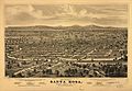
Panoramic map of Santa Rosa from 1871
-
The Empire Building at Old Courthouse Square, downtown Santa Rosa
-
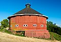
The historic Fountaingrove Round Barn, previously found at the southwestern base of Fountaingrove, was lost to fire in 2017.
-
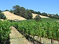
While the most expansive vineyards in Sonoma County lie within the Alexander, Russian River and Sonoma Valleys, Santa Rosa is home to several vineyards such as this one near Fountain Grove.
-
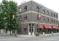
The Hotel La Rose, built in 1907, is a functioning historic hotel in downtown Santa Rosa.
-
The Charles M. Schulz Museum and Research Center is on the corner of West Steele Lane and Hardies Lane, next to Snoopy's Home Ice skating rink.
-
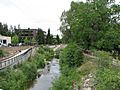
Prince Memorial Greenway is a bicycle and pedestrian path through downtown Santa Rosa.
-
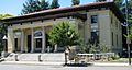
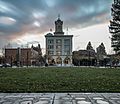
The Sonoma County Museum on 7th St., Downtown Santa Rosa. Completed in 1910, it was originally the Post Office and Federal Building.
-
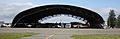
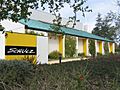
Airplane hangar used in the film It's a Mad, Mad, Mad, Mad World
-
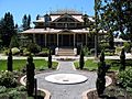
McDonald Mansion, Santa Rosa, exterior used in Pollyanna
.jpg)


See also
 In Spanish: Santa Rosa (California) para niños
