
Santiago Rodríguez Province facts for kids
Quick facts for kids Santiago Rodríguez |
||
| Province | ||
|
||
| Country | ||
|---|---|---|
| Development region | Cibao Noroeste (IV) | |
| Capital | San Ignacio de Sabaneta | |
| - elevation | 127 m (417 ft) | |
| - coordinates | 19°29′0″N 71°21′0″W / 19.48333°N 71.35000°W | |
| Area | 1,147.5 km² (443 sq mi) | |
| Population | 99,044 (2014) | |
| Density | 86 /km² (223 /sq mi) | |
| Province since | 1948 | |
| Subdivisions | 3 municipalities 0 municipal districts |
|
| Congresspersons | 1 Senator 2 Deputies |
|
| Timezone | EST (UTC-4) | |
| Area code | 1-809 1-829 1-849 | |
| ISO 3166-2 | DO-26 | |

Santiago Rodríguez is a province of the Dominican Republic. It is in the northwestern part of the country. Its capital city is San Ignacio de Sabaneta.
The province was created in 1948.
Contents
Name
Santiago Rodríguez was an officer of the Dominican army when the Dominican-Haitian War. He is one of the founder of the city of Sabaneta. He was an important military leader during the initial stages of the Restoration War (1863-1865).
History
The town of San Ignacio de Sabaneta was founded in 1844 and it was made a municipality of the Santiago province in 1854 and then of the Monte Cristi Province province in 1879. In 1948, it became a province.
Monción was a municipality of Montecristi since 1907. In 1996, Villa Los Almácigos became a municipality.
Location
Santiago Rodríguez is in the region known as Línea Noroeste ("Northwestern Line"). The province has the Monte Cristi and Valverde provinces to the north, the Santiago province to the east, the San Juan and Elías Piña provinces to the south and the Dajabón province to the west.
 |
Monte Cristi | Valverde | |
|
| Dajabón | Santiago | |||
| Elías Piña | San Juan |
Population
In 2014 (last national census), there were 99,044 people living in the Santiago Rodríguez province, and 27,559 (27.8%) living in towns and cities. The population density was 86.3 persons/km².
Its population represents 1.05% of the total population of the country and the province is ranked as the 30th (out of 31 plus the National District) more populated province.
As of 2016[update], the total estimated propulation of the province is 1,015,397 inhabitants.
The largest city of the province is San Ignacio de Sabaneta, its head municipality or capital, with an urban population (in 2014) of 15,648 inhabitants.
Geography
The Santiago province has a total area of 1,147.5 km2 (443.1 sq mi). It has 2.4% of the area of the Dominican Republic and it is ranked as the 22nd (out of 31 plus the National District) largest province.
The altitude of the provincial capital, San Ignacio de Sabaneta, is 127 m (417 ft) above sea level.
The Cordillera Central ("Central mountain chain") is in the southern part of the province, and the Sierra Samba (or Sierra Zamba), a chain of low hills, runs across the northern half.
The main rivers are Guayubín and Mao, both tributaries of the Yaque del Norte river.
Climate
The climate of the province is a tropical climate, hot most of the year, but it is cooler in the mountains.
Municipalities
There are 3 municipalities and none municipal districts (M.D.) in the province.

| Municipality (code) |
Municipal Districts (code) | Population (2010) |
Area (km2) |
Density | Altitude (m) |
|---|---|---|---|---|---|
| San Ignacio de Sabaneta (260101) | 34,540 | 801.4 | 43.1 | 127 | |
| Sabaneta (260100) | 34,540 | 801.4 | 43.1 | ||
| Villa Los Almácigos (260201) | 11,183 | 207.2 | 54.0 | 211 | |
| Villa Los Almácigos (260200) | 11,183 | 207.2 | 54.0 | ||
| Monción (260301) | 11,753 | 138.9 | 84.6 | 367 | |
| Monción (260300)) | 11,753 | 138.9 | 84.6 | ||
| Santiago Rodríguez (260000) | 99,044 | 1,147.5 | 86.3 | ||
Economy
The only economic activity of importance is farming.
Images for kids
-

Santiago Rodríguez
-
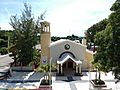
Church of San Antonio, Moncion, Dominican Republic.


See also
 In Spanish: Provincia de Santiago Rodríguez para niños
