
Sargent County, North Dakota facts for kids
Quick facts for kids
Sargent County
|
|
|---|---|

|
|

Location within the U.S. state of North Dakota
|
|
 North Dakota's location within the U.S. |
|
| Country | |
| State | |
| Founded | April 9, 1883 (created) October 8, 1883 (organized) |
| Named for | H. E. Sargent |
| Seat | Forman |
| Largest city | Gwinner |
| Area | |
| • Total | 867 sq mi (2,250 km2) |
| • Land | 859 sq mi (2,220 km2) |
| • Water | 8.4 sq mi (22 km2) 1.0% |
| Population
(2020)
|
|
| • Total | 3,862 |
| • Estimate
(2021)
|
3,829 |
| • Density | 4.4544/sq mi (1.7199/km2) |
| Time zone | UTC−6 (Central) |
| • Summer (DST) | UTC−5 (CDT) |
| Congressional district | At-large |
Sargent County is a county in the U.S. state of North Dakota. As of the 2020 census, the population was 3,862. Its county seat is Forman.
Contents
History

In 1997 the Brampton Lutheran Church (originally built in 1908) was moved to Sletta near Radøy in Norway and reconstructed there. It is now called Emigrantkirka (Emigrant Church).
The Sargent County Courthouse, a Beaux Arts-style building built in 1910, is listed on the U.S. National Register of Historic Places.
Geography
According to the U.S. Census Bureau, the county has a total area of 867 square miles (2,250 km2), of which 859 square miles (2,220 km2) is land and 8.4 square miles (22 km2) (1.0%) is water.
Major highways
 North Dakota Highway 11
 North Dakota Highway 13
 North Dakota Highway 32
Adjacent counties
- Ransom County (north)
- Richland County (east)
- Marshall County, South Dakota (south)
- Brown County, South Dakota (southwest)
- Dickey County (west)
- LaMoure County, North Dakota (northwest)
National protected areas
- Storm Lake National Wildlife Refuge
- Tewaukon National Wildlife Refuge
- Wild Rice Lake National Wildlife Refuge
Demographics
| Historical population | |||
|---|---|---|---|
| Census | Pop. | %± | |
| 1890 | 5,076 | — | |
| 1900 | 6,039 | 19.0% | |
| 1910 | 9,202 | 52.4% | |
| 1920 | 9,655 | 4.9% | |
| 1930 | 9,298 | −3.7% | |
| 1940 | 8,693 | −6.5% | |
| 1950 | 7,616 | −12.4% | |
| 1960 | 6,856 | −10.0% | |
| 1970 | 5,937 | −13.4% | |
| 1980 | 5,512 | −7.2% | |
| 1990 | 4,549 | −17.5% | |
| 2000 | 4,366 | −4.0% | |
| 2010 | 3,829 | −12.3% | |
| 2020 | 3,862 | 0.9% | |
| 2021 (est.) | 3,829 | 0.0% | |
| U.S. Decennial Census 1790–1960 1900–1990 1990–2000 2010–2020 |
|||
2010 census
As of the 2010 census, there were 3,829 people, 1,675 households and 1,113 families in the county. The population density was 4.46/sqmi (1.72/km2). There were 2,004 housing units at an average density of 2.33/sqmi (0.90/km2). The racial makeup of the county was 98.0% white, 0.5% American Indian, 0.2% Asian, 0.1% Pacific islander, 0.1% black or African American, 0.3% from other races, and 0.7% from two or more races. Those of Hispanic or Latino origin made up 1.3% of the population. In terms of ancestry, 51.3% were German, 35.9% were Norwegian, 11.8% were Swedish, 8.4% were Irish, and 3.0% were American.
Of the 1,675 households, 27.1% had children under the age of 18 living with them, 57.3% were married couples living together, 4.7% had a female householder with no husband present, 33.6% were non-families, and 30.2% of all households were made up of individuals. The average household size was 2.26 and the average family size was 2.79. The median age was 45.9 years.
The median income for a household in the county was $49,318 and the median income for a family was $59,531. Males had a median income of $43,594 versus $30,152 for females. The per capita income for the county was $26,553. About 5.7% of families and 7.8% of the population were below the poverty line, including 10.5% of those under age 18 and 10.4% of those age 65 or over.
Communities
Cities
Townships
- Bowen
- Brampton
- Denver
- Dunbar
- Forman
- Hall
- Harlem
- Herman
- Jackson
- Kingston
- Marboe
- Milnor
- Ransom
- Rutland
- Sargent
- Shuman
- Southwest
- Taylor
- Tewaukon
- Verner
- Vivian
- Weber
- Whitestone Hill
- Willey
Census-designated place
Unincorporated community
Images for kids
-
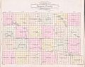
Outline map of Sargent County, North Dakota, 1909

See also
 In Spanish: Condado de Sargent para niños
