
Sarnen facts for kids
Quick facts for kids
Sarnen
|
||
|---|---|---|
|
||
| Country | Switzerland | |
| Canton | Obwalden | |
| District | n.a. | |
| Area | ||
| • Total | 73.12 km2 (28.23 sq mi) | |
| Elevation | 473 m (1,552 ft) | |
| Population
(Dec 2020 )
|
||
| • Total | 10,514 | |
| • Density | 143.791/km2 (372.42/sq mi) | |
| Postal code |
6060-6061
|
|
| Surrounded by | Alpnach, Entlebuch (LU), Flühli (LU), Giswil, Hasle (LU), Kerns, Sachseln | |

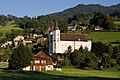
Sarnen is a small historic town, a municipality, and the capital of the canton of Obwalden situated on the northern shores of Lake Sarnen (German: Sarnersee) in Switzerland. It has a population of just over 10,000 and is surrounded by countryside and mountains. Sarnen is located 20 km south of Lucerne.
The official language of Sarnen is (the Swiss variety of Standard) German, but the main spoken language is the local variant of the Alemannic Swiss German dialect.
Contents
History
Stone Age and Bronze Age finds show that the Sarnen valley was inhabited from the earliest times. Over the years Sarnen developed into an important trading center.
Geography

Sarnen is situated at an altitude of 471 m (1,545 ft) on the northern shore of Lake Sarnen (German: Sarnersee) along the outflow of the Sarner Aa. Lake Sarnen covers approximately an area of 7.5 km2 (2.9 sq mi). The town is surrounded by mountain chains and a protected bog can be found nearby. The most well-known mountain close to Sarnen is Mount Pilatus with an elevation of 2,132 m (6,995 ft).
Sarnen has an area, (as of the 2004/09 survey) of 73.12 km2 (28.23 sq mi). Of this area, about 39.0% is used for agricultural purposes, while 50.7% is forested. Of the rest of the land, 6.0% is settled (buildings or roads) and 4.3% is unproductive land. In the 2004/09 survey a total of 260 ha (640 acres) or about 3.6% of the total area was covered with buildings, an increase of 78 ha (190 acres) over the 1980/81 amount. Of the agricultural land, 46 ha (110 acres) is used for orchards and vineyards, 1,554 ha (3,840 acres) is fields and grasslands and 1,665 ha (4,110 acres) consists of alpine grazing areas. Since 1980/81 the amount of agricultural land has decreased by 172 ha (430 acres). Over the same time period the amount of forested land has increased by 27 ha (67 acres). Rivers and lakes cover 111 ha (270 acres) in the municipality.
The municipality is made up of 5 sections; Sarnen (population 5,984), Stalden (pop. 1,072), Wilen (pop. 1,234), Kägiswil (pop. 1,214) and Ramersberg (pop. 294).
Images for kids
-
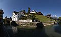
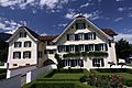
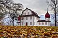
Houses around the Landenberg hill.
-
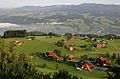
Flüeli-Ranft village above Sarnen.
-
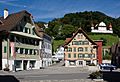
Dorfplatz
-
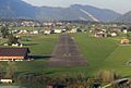
Kägiswil landing strip near Sarnen
-
Ossuary of St. Michael
-
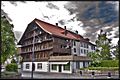
Double house am Grund
-
Double house Grundacher
-
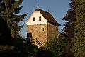
Hexenturm
-
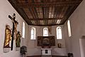
Catholic parish church of St. Peter and Paul
-
Kollegiumskirche of St. Martin
-
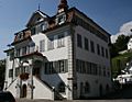
Rathaus of Obwalden
-
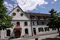
The Frauenkloster
-
Landenberg Armory
-
State Archives of Obwalden


See also
 In Spanish: Sarnen para niños
