Scott County, Iowa facts for kids
Quick facts for kids
Scott County
|
||
|---|---|---|
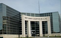
Scott County Courthouse
|
||
|
||
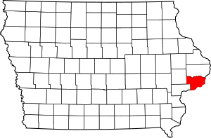
Location within the U.S. state of Iowa
|
||
 Iowa's location within the U.S. |
||
| Country | ||
| State | ||
| Founded | 1837 | |
| Named for | Winfield Scott | |
| Seat | Davenport | |
| Largest city | Davenport | |
| Area | ||
| • Total | 468 sq mi (1,210 km2) | |
| • Land | 458 sq mi (1,190 km2) | |
| • Water | 10 sq mi (30 km2) 2.2% | |
| Population
(2020)
|
||
| • Total | 174,669 | |
| • Density | 373.2/sq mi (144.10/km2) | |
| Time zone | UTC−6 (Central) | |
| • Summer (DST) | UTC−5 (CDT) | |
| Congressional district | 2nd | |
Scott County is a county located in the U.S. state of Iowa. As of the 2020 census, the population was 174,669, making it the third-most populous county in Iowa. The county seat is Davenport.
Scott County is included in the Davenport–Moline-Rock Island, IA–IL Metropolitan Statistical Area.
Contents
History
The first American settlement in the area now known as Scott County was Clark's Ferry or Clark's Landing (now Buffalo) in 1833. Other early towns included Davenport (now the county seat and largest city) and the town of Rockingham (which ceased to exist in 1847). The area was fully surveyed in 1837, and the county was established by the Wisconsin territorial legislature in that same year. Scott County is named for General Winfield Scott, who was the presiding officer at the signing of the peace treaty ending the Black Hawk War.
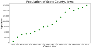
By 1900 the population of the county was 51,500, and by 1950 it was over 100,000. Scott County now comprises part of the Quad City region, which includes the cities of Davenport and Bettendorf (in Iowa) and Rock Island, Moline and East Moline (in Illinois).
The present Scott County Courthouse was completed in 1955 and expanded along with the jail in 2007. The old section of the Scott County Jail was listed on the National Register of Historic Places in 1983.
Geography
According to the U.S. Census Bureau, the county has a total area of 468 square miles (1,210 km2), of which 458 square miles (1,190 km2) is land and 10 square miles (26 km2) (2.2%) is water.
Major highways
 Interstate 74
 Interstate 80
 Interstate 280
 U.S. Highway 6
 U.S. Highway 61
 U.S. Highway 67
 Iowa Highway 22
 Iowa Highway 130
Adjacent counties
- Clinton County (north)
- Rock Island County, Illinois (east & south)
- Muscatine County (southwest)
- Cedar County (northwest)
Demographics
| Historical population | |||
|---|---|---|---|
| Census | Pop. | %± | |
| 1850 | 5,986 | — | |
| 1860 | 25,959 | 333.7% | |
| 1870 | 38,599 | 48.7% | |
| 1880 | 41,266 | 6.9% | |
| 1890 | 43,164 | 4.6% | |
| 1900 | 51,558 | 19.4% | |
| 1910 | 60,000 | 16.4% | |
| 1920 | 73,952 | 23.3% | |
| 1930 | 77,332 | 4.6% | |
| 1940 | 84,748 | 9.6% | |
| 1950 | 100,698 | 18.8% | |
| 1960 | 119,067 | 18.2% | |
| 1970 | 142,687 | 19.8% | |
| 1980 | 160,022 | 12.1% | |
| 1990 | 150,973 | −5.7% | |
| 2000 | 158,668 | 5.1% | |
| 2010 | 165,224 | 4.1% | |
| 2020 | 174,669 | 5.7% | |
| U.S. Decennial Census 1790-1960 1900-1990 1990-2000 2010-2019 |
|||
The US Census Bureau estimated Scott County's population at 170,385 in 2013, fourth fastest-growing out of Iowa's 99 counties after Dallas County, a western suburb of Des Moines: Johnson, Polk, followed by Warren County being the top five.
2020 census
The 2020 census recorded a population of 174,669 in the county, with a population density of 373.8768/sq mi (144.3546/km2). 92.61% of the population reported being of one race. 72.51% were non-Hispanic White, 8.08% were Black, 6.92% were Hispanic, 0.33% were Native American, 2.78% were Asian, 0.03% were Native Hawaiian or Pacific Islander and 9.33% were some other race or more than one race. There were 77,771 housing units, of which 71,628 were occupied.
2010 census
The 2010 census recorded a population of 165,224 in the county, with a population density of 360.806/sq mi (139.308/km2). There were 71,835 housing units, of which 66,765 were occupied.
Communities
Cities
Census-designated place
Other unincorporated communities
- Big Rock
- Desmond Acres
- Westdale
Townships
- Allens Grove
- Blue Grass
- Buffalo
- Butler
- Cleona
- Davenport (City)
- Hickory Grove
- Le Claire
- Liberty
- Lincoln
- Pleasant Valley
- Princeton
- Sheridan
- Winfield
Former township
Population ranking
The population ranking of the following table is based on the 2010 census of Scott County.
† county seat
| Rank | City/Town/etc. | Municipal type | Population (2010 Census) |
|---|---|---|---|
| 1 | † Davenport | City | 99,685 |
| 2 | Bettendorf | City | 33,217 |
| 3 | Eldridge | City | 5,651 |
| 4 | Le Claire | City | 3,765 |
| 5 | Park View | CDP | 2,389 |
| 6 | Durant (partially in Cedar and Muscatine Counties) | City | 1,832 |
| 7 | Walcott (partially in Muscatine County) | City | 1,629 |
| 8 | Blue Grass (partially in Muscatine County) | City | 1,452 |
| 9 | Buffalo | City | 1,270 |
| 10 | Princeton | City | 886 |
| 11 | Long Grove | City | 808 |
| 12 | Riverdale | City | 405 |
| 13 | Donahue | City | 346 |
| 14 | McCausland | City | 291 |
| 15 | Dixon | City | 247 |
| 16 | Maysville | City | 176 |
| 17 | New Liberty | City | 137 |
| 18 | Panorama Park | City | 129 |
| 19 | Desmond Acres | City | 97 |
Education
Public school districts in Scott County include:
- Bettendorf Community School District, Bettendorf
- Calamus–Wheatland Community School District, Wheatland
- Davenport Community School District, Davenport
- Durant Community School District, Durant
- North Scott Community School District, Eldridge
- Pleasant Valley Community School District, Riverdale, Bettendorf, LeClaire
Higher education institutions
- Scott Community College is located in Riverdale
- Saint Ambrose University is located in Davenport
See also
 In Spanish: Condado de Scott (Iowa) para niños


