
Sebastopol, New South Wales facts for kids
Quick facts for kids SebastopolNew South Wales |
|
|---|---|

Entering Sebastopol
|
|

Sebastopol
Location in New South Wales
|
|
| Postcode(s) | 2666 |
| Elevation | 299 m (981 ft) |
| Location |
|
| LGA(s) | Temora Shire |
| County | Clarendon |
| State electorate(s) | Cootamundra |
| Federal Division(s) | Riverina |
Sebastopol is a village community in the north east part of the Riverina. It is situated by road, about 15 kilometres south of Temora and 19 kilometres north of Junee Reefs.
The village is located by signage on the Goldfields Way. Other than rural dwellings surrounding the village the only sign of a more prosperous past is a dilapidated building well past its prime and a well constructed brick Presbyterian church on the nearby Mimosa Road close to the intersection of Henrys Road.
It was named after Sevastopol, the site of an important battle during the Crimean War. Gold was mined there from around 1870. Sebastopol Post Office opened on 7 March 1870 and closed in 1973. Sebastopol had a school from 1871 to 1949.
-
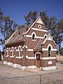
St Stephen's Church Sebastopol
-
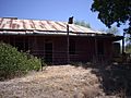
Ruins at Sebastopol


