
Shadwell, West Yorkshire facts for kids
Quick facts for kids Shadwell |
|
|---|---|
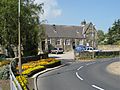
 Main Street: Red Lion and Post Office |
|

Shadwell
|
|
| Population | 1,849 (2011 census) |
| Civil parish |
|
| Metropolitan borough | |
| Metropolitan county | |
| Region | |
| Country | England |
| Sovereign state | United Kingdom |
| Post town | LEEDS |
| Postcode district | LS17 |
| Dialling code | 0113 |
| Police | West Yorkshire |
| Fire | West Yorkshire |
| Ambulance | Yorkshire |
| EU Parliament | Yorkshire and the Humber |
| UK Parliament |
|
Shadwell is a village and civil parish in north-east Leeds, West Yorkshire, England. The village is 6 miles (9.7 km) to the north east of Leeds city centre.
It sits in the Harewood ward of Leeds City Council and Elmet and Rothwell parliamentary constituency. The village is in the LS17 postal code and is served by the Shadwell Parish Council.
Shadwell borders with areas including Alwoodley, Roundhay, Whinmoor and Moortown and is being increasingly referred to simply as an area or suburb of Leeds but retains its many village traditions. It had a population of 1,864 in 2001, reducing to 1,849 at the 2011 Census.
History
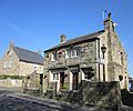
The first written proof of Shadwell's existence is in 1086 in William the Conqueror's Domesday Book, where it is called Scadewelle. Shadwell is thought to be named after the numerous trees that once covered the village with shade and the many wells that were once in use throughout the village. The village pub "The Red Lion" is located between two wells which were originally used to gather water for the brewing process.
Shadwell was historically a township in the ancient parish of Thorner in the West Riding of Yorkshire. Roundhay Grange, originally a grange of Kirkstall Abbey, was a detached part of the township. In 1866 the township became a separate civil parish, but in 1912 the parish was abolished and absorbed into Leeds.
In 1974 Shadwell became part of the enlarged City of Leeds in the new county of West Yorkshire. In 2002 the civil parish was reconstituted, with an elected parish council.
Amenities

The village has two churches (the Church of England St Paul's, and Shadwell Methodist Chapel), a primary school, The Red Lion pub, the Village Hall, a social club, a tennis club, a golf club and six shops (clothing shop, beauty shop, dry cleaner, fish and chip shop, post-office/newsagent and a hairdresser). The library, which has operated independently since 2013, is a Grade II Listed Building which served as the Methodist Chapel from 1814 to 1892. There is also a cricket club. Shadwell United is a junior football club which trains at the primary school. There are thriving Scouts, Cubs, Beavers, Guides and Ranger groups. There is a stone millennium wheel on Main Street, Shadwell.
Slaid Hill
Slaid Hill is an area of Leeds which is within the manor or traditional estate of Shadwell, but is about half a mile west of Shadwell village with clear countryside between them, and the Shadwell name sign between. Slaid Hill is within the Alwoodley Council Ward, whereas Shadwell village is within the Harewood ward.
Today, Shadwell Parish excludes most of Slaid Hill, but includes the estate to the south of Shadwell Lane and east of Roundhay Park Lane. The 1881 Census makes it clear that the district of Shadwell extended to the west end of Shadwell Lane and to the Moortown Ring Road in the South. In addition Shadwell Grange is a large house and farm in Slaid Hill, with a view over the Moortown Ring Road. It is a Grade II listed building.
-
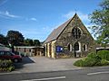
Shadwell Village Hall
-
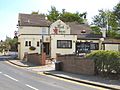
Red Lion
-
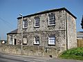
Shadwell Library
-
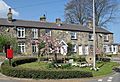
Millennium Wheel and cottages
-
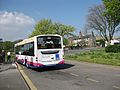
Terminus for the 7S Bus Leeds-Shadwell
-
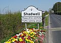
Sign going from Slaid Hill to Shadwell
-
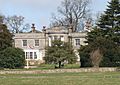
Shadwell Grange viewed from the Leeds Ring Road
-
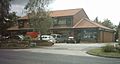
One of the parades of Shops in Slaid Hill


Location grid
 |
Wike | |
||
| Alwoodley | Scarcroft | |||
| Roundhay |
- The ancient parish of Thorner: historical and genealogical information at GENUKI (Shadwell was in this parish).
Images for kids
-
Methodist Church
-
Fish and chip shop


See also
 In Spanish: Shadwell (Yorkshire del Oeste) para niños
