Shannon County, Missouri facts for kids
Quick facts for kids
Shannon County
|
|
|---|---|

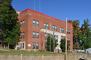
Shannon County courthouse in Eminence
|
|

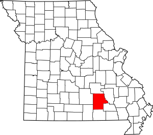
Location within the U.S. state of Missouri
|
|
 Missouri's location within the U.S. |
|
| Country | |
| State | |
| Founded | January 29, 1841 |
| Named for | George Shannon |
| Seat | Eminence |
| Largest city | Winona |
| Area | |
| • Total | 1,004 sq mi (2,600 km2) |
| • Land | 1,004 sq mi (2,600 km2) |
| • Water | 0.2 sq mi (0.5 km2) 0.02% |
| Population
(2020)
|
|
| • Total | 7,031 |
| • Density | 7.003/sq mi (2.7039/km2) |
| Time zone | UTC−6 (Central) |
| • Summer (DST) | UTC−5 (CDT) |
| Congressional district | 8th |
Shannon County is a county in the southern portion of the U.S. state of Missouri. As of the 2020 census, the population was 7,031. Its county seat is Eminence. The county was officially organized on January 29, 1841, and was named in honor of George F. "Peg-Leg" Shannon, a member of the Lewis and Clark Expedition. It is the second-largest county by area in Missouri.
Missouri's first copper mine was opened in Shannon County in 1846 and Missouri's only manganese mine was opened here during World War II.
As of the 2000 census, Shannon County ranked 78th on the list of counties with the lowest per capita income and 46th on the list of counties with the lowest median household incomes in the United States, making it the poorest county in Missouri.
Contents
History
The Great Tri-State Tornado of March 18, 1925 appears to have begun in Moore Township; most likely as constituent tornadoes of a tornado family preceding the infamous very long tack tornado that went on to kill 695 people across southeastern Missouri, southern Illinois, and southwestern Indiana over the next several hours.
Geography
According to the U.S. Census Bureau, the county has a total area of 1,004 square miles (2,600 km2), of which 1,004 square miles (2,600 km2) is land and 0.2 square miles (0.52 km2) (0.02%) is water.
Adjacent counties
- Dent County (north)
- Reynolds County (east)
- Carter County (southeast)
- Oregon County (south)
- Howell County (southwest)
- Texas County (west)
Major highways
National protected areas
- Mark Twain National Forest (part)
- Ozark National Scenic Riverways (part)
Demographics
| Historical population | |||
|---|---|---|---|
| Census | Pop. | %± | |
| 1850 | 1,199 | — | |
| 1860 | 2,284 | 90.5% | |
| 1870 | 2,339 | 2.4% | |
| 1880 | 3,441 | 47.1% | |
| 1890 | 8,898 | 158.6% | |
| 1900 | 11,247 | 26.4% | |
| 1910 | 11,443 | 1.7% | |
| 1920 | 11,865 | 3.7% | |
| 1930 | 10,894 | −8.2% | |
| 1940 | 11,831 | 8.6% | |
| 1950 | 8,377 | −29.2% | |
| 1960 | 7,087 | −15.4% | |
| 1970 | 7,196 | 1.5% | |
| 1980 | 7,885 | 9.6% | |
| 1990 | 7,613 | −3.4% | |
| 2000 | 8,324 | 9.3% | |
| 2010 | 8,441 | 1.4% | |
| 2020 | 7,031 | −16.7% | |
| U.S. Decennial Census 1790–1960 1900–1990 1990–2000 2010–2015 |
|||
As of the census of 2000, there were 8,324 people, 3,319 households, and 2,356 families residing in the county. The population density was 3/km2 (8/mi2). There were 3,862 housing units at an average density of 1/km2 (4/mi2). The racial makeup of the county was 95.05% White, 0.17% Black or African American, 1.83% Native American, 0.05% Asian, 0.02% Pacific Islander, 0.19% from other races, and 2.69% from two or more races. Approximately 0.93% of the population were Hispanic or Latino of any race. Among the major first ancestries reported in Shannon County were 38.3% American, 13.4% Irish, 11.8% German, and 9.7% English.
There were 3,319 households, out of which 32.50% had children under the age of 18 living with them, 58.80% were married couples living together, 8.20% had a female householder with no husband present, and 29.00% were non-families. 25.80% of all households were made up of individuals, and 12.60% had someone living alone who was 65 years of age or older. The average household size was 2.49 and the average family size was 2.97.
In the county, the population was spread out, with 26.40% under the age of 18, 7.20% from 18 to 24, 26.10% from 25 to 44, 25.30% from 45 to 64, and 15.00% who were 65 years of age or older. The median age was 39 years. For every 100 females there were 95.30 males. For every 100 females age 18 and over, there were 92.60 males.
The median income for a household in the county was $24,835, and the median income for a family was $30,102. Males had a median income of $21,917 versus $16,024 for females. The per capita income for the county was $13,127. About 21.00% of families and 26.90% of the population were below the poverty line, including 35.10% of those under age 18 and 20.20% of those age 65 or over.
Religion
According to the Association of Religion Data Archives County Membership Report (2000), Shannon County is a part of the Bible Belt with evangelical Protestantism being the majority religion. The most predominant denominations among residents in Shannon County who adhere to a religion are Southern Baptists (56.22%), Methodists (12.03%), and Christian Churches & Churches of Christ (10.84%).
Communities
Cities
- Birch Tree
- Eminence (county seat)
- Summersville
- Winona
Census-designated place
Other unincorporated places
Education
Of adults 25 years of age and older, 44.9% possesses a high school diploma or higher while 9.6% holds a bachelor's degree or higher as their highest educational attainment.
Public Schools
-
- Eminence Elementary School (PK-06)
- Eminence High School (07-12)
- Winona Elementary School (PK-08)
- Winona High School (09-12)
Public libraries
- Birch Tree City Library
- Eminence Public Library
- Winona Public Library
See also
 In Spanish: Condado de Shannon (Misuri) para niños

