
Shap facts for kids
Quick facts for kids Shap |
|
|---|---|
 Shap Market Cross |
|

Shap
|
|
| Population | 1,264 (2011) |
| OS grid reference | NY563150 |
| Civil parish |
|
| District | |
| Shire county | |
| Region | |
| Country | England |
| Sovereign state | United Kingdom |
| Post town | PENRITH |
| Postcode district | CA10 |
| Dialling code | 01931 |
| Police | Cumbria |
| Fire | Cumbria |
| Ambulance | North West |
| EU Parliament | North West England |
| UK Parliament |
|
Shap is a linear village and civil parish located among fells and isolated dales in Eden district, Cumbria, England. The village lies along the A6 road and the West Coast Main Line, and is near to the M6 motorway. It is situated 10 miles (16 km) from Penrith and about 15 miles (24 km) from Kendal, in the historic county of Westmorland.
Images for kids
-
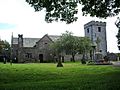
St. Michael's Church
-
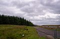
Shap Summit


See also
 In Spanish: Shap para niños

All content from Kiddle encyclopedia articles (including the article images and facts) can be freely used under Attribution-ShareAlike license, unless stated otherwise. Cite this article:
Shap Facts for Kids. Kiddle Encyclopedia.