
Sharon, Queensland facts for kids
Quick facts for kids SharonQueensland |
|||||||||||||||
|---|---|---|---|---|---|---|---|---|---|---|---|---|---|---|---|

Sharon
Location in Queensland
|
|||||||||||||||
| Population | 1,316 (2016 census) | ||||||||||||||
| • Density | 26.97/km2 (69.9/sq mi) | ||||||||||||||
| Postcode(s) | 4670 | ||||||||||||||
| Area | 48.8 km2 (18.8 sq mi) | ||||||||||||||
| Time zone | AEST (UTC+10:00) | ||||||||||||||
| Location |
|
||||||||||||||
| LGA(s) | Bundaberg Region | ||||||||||||||
| State electorate(s) | Burnett | ||||||||||||||
| Federal Division(s) | Flynn | ||||||||||||||
|
|||||||||||||||
Sharon is a rural locality in the Bundaberg Region, Queensland, Australia. In the 2016 census, Sharon had a population of 1,316 people.
Contents
History

The locality is named after the Sharon plain in Israel.
Heritage listings

Sharon has the following heritage listings:
Education
Sharon State School is a government primary (Prep-6) school for boys and girls at 18 Sharon School Road (24°52′21″S 152°15′48″E / 24.8724°S 152.2633°E). In 2018, the school had an enrolment of 116 students with 10 teachers (8 full-time equivalent) and 8 non-teaching staff (5 full-time equivalent).
There are no secondary schools in Sharon. The nearest government secondary school is Bundaberg North State High School in Bundaberg North to the north-east.
Images for kids
-
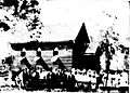
Opening of the Church of England at Sharon, circa February 1935

