Sharpsville, Pennsylvania facts for kids
Quick facts for kids
Sharpsville, Pennsylvania
|
|
|---|---|
|
Borough
|
|

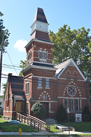
First Universalist Church, a historic site in the borough
|
|

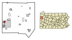
Location of Sharpsville in Mercer County, Pennsylvania.
|
|
| Country | United States |
| State | Pennsylvania |
| County | Mercer |
| Established | 1874 |
| Area | |
| • Total | 1.40 sq mi (3.63 km2) |
| • Land | 1.39 sq mi (3.60 km2) |
| • Water | 0.01 sq mi (0.03 km2) |
| Elevation
(center of borough)
|
1,000 ft (300 m) |
| Highest elevation
(southeast corner of borough)
|
1,140 ft (350 m) |
| Lowest elevation | 870 ft (270 m) |
| Population
(2010)
|
|
| • Total | 4,415 |
| • Estimate
(2019)
|
4,074 |
| • Density | 2,928.83/sq mi (1,130.82/km2) |
| Time zone | UTC-4 (EST) |
| • Summer (DST) | UTC-5 (EDT) |
| Zip code |
16150
|
| Area code(s) | 724 |
| Website | www.sharpsville.org |
Sharpsville is a borough in Mercer County, Pennsylvania, United States, along the Shenango River. The population was 4,074 as of 2019 (In a Census Bureau estimate). It is part of the Youngstown-Warren-Boardman, OH-PA Metropolitan Statistical Area.
Contents
History
The First Universalist Church of Sharpsville and Jonas J. Pierce House are listed on the National Register of Historic Places.
Geography
Sharpsville is located at 41°15′32″N 80°28′54″W / 41.25889°N 80.48167°W (41.259005, -80.481791).
According to the United States Census Bureau, the borough has a total area of 1.4 square miles (3.6 km2), of which 1.4 square miles (3.6 km2) is land and 0.04 square miles (0.10 km2) (1.42%) is water.
Demographics
| Historical population | |||
|---|---|---|---|
| Census | Pop. | %± | |
| 1880 | 1,824 | — | |
| 1890 | 2,330 | 27.7% | |
| 1900 | 2,970 | 27.5% | |
| 1910 | 3,634 | 22.4% | |
| 1920 | 4,674 | 28.6% | |
| 1930 | 5,194 | 11.1% | |
| 1940 | 5,129 | −1.3% | |
| 1950 | 5,414 | 5.6% | |
| 1960 | 6,061 | 12.0% | |
| 1970 | 6,126 | 1.1% | |
| 1980 | 5,375 | −12.3% | |
| 1990 | 4,729 | −12.0% | |
| 2000 | 4,500 | −4.8% | |
| 2010 | 4,415 | −1.9% | |
| 2022 (est.) | 3,930 | −11.0% | |
| Sources: | |||
As of the census of 2022, there were 3,930 people, 1,971 households and 804 families residing in the borough. The population density was 2,825 per square mile (1,250.0/km2). There were 2,016 housing units at an average density of 1,453.4 per square mile (560.0/km2). The racial makeup of the borough was 97.53% White, 1.22% African American, 0.91% Asian, and 0.34% from two or more races. Hispanic or Latino of any race were 0.6% of the population.
There were 1,971 households, of which 40.8% were married couples living together, 14.9% had a female householder with no husband present, 4% had a male householder with no wife present, and 40.4% were non-families. The average household size was 2.11 and the average family size was 2.77.
In the borough the population was spread out, with 28.9% under the age of 20, 24.8% from 21 to 40, 29.6% from 41 to 60, and 16.9% from 60 to 80+. The median age was 44.5 years, for males it is 42.5, and females 47.2. The sex ratio is 2,269 female at 54.4%, and male at 1,899 at 45.6%.
The median income for a household in the borough was $46,523, and the median income for a family was $65,000. Males had a median income of $41,900 versus $31,439 for females. The per capita income for the borough was $29,830. About 12.6% of the population were below the poverty line, including 25% of those under age 18 and 4% of those age 65 or over.
Notable people
- Carmen Argenziano – actor
- Marvin Pierce – president of American magazine publisher McCall Corporation, and father of United States First Lady Barbara Pierce Bush
- Brian L. Stafford – 20th Director of the United States Secret Service
See also
 In Spanish: Sharpsville (Pensilvania) para niños


