
Sheridan County, North Dakota facts for kids
Quick facts for kids
Sheridan County
|
|
|---|---|

Sheridan County Courthouse (McClusky, North Dakota)
|
|

Location within the U.S. state of North Dakota
|
|
 North Dakota's location within the U.S. |
|
| Country | |
| State | |
| Founded | January 4, 1873 (created) December 24, 1908 (organized) |
| Named for | Philip Henry Sheridan |
| Seat | McClusky |
| Largest city | McClusky |
| Area | |
| • Total | 1,006 sq mi (2,610 km2) |
| • Land | 972 sq mi (2,520 km2) |
| • Water | 33 sq mi (90 km2) 3.3% |
| Population
(2020)
|
|
| • Total | 1,265 |
| • Estimate
(2021)
|
1,268 |
| • Density | 1.2575/sq mi (0.4855/km2) |
| Time zone | UTC−6 (Central) |
| • Summer (DST) | UTC−5 (CDT) |
| Congressional district | At-large |
Sheridan County is a county located in the U.S. state of North Dakota. As of the 2020 census, the population was 1,265, making it the third-least populous county in North Dakota. Its county seat is McClusky.
Contents
Geography
According to the U.S. Census Bureau, the county has a total area of 1,006 square miles (2,610 km2), of which 972 square miles (2,520 km2) is land and 33 square miles (85 km2) (3.3%) is water.
Major highways
 U.S. Highway 52
 North Dakota Highway 14
 North Dakota Highway 53
 North Dakota Highway 200
Adjacent counties
- McHenry County (north)
- Pierce County (northeast)
- Wells County (east)
- Kidder County (southeast)
- Burleigh County (south)
- McLean County (west)
National protected area
- Sheyenne Lake National Wildlife Refuge
Demographics
| Historical population | |||
|---|---|---|---|
| Census | Pop. | %± | |
| 1910 | 8,103 | — | |
| 1920 | 7,935 | −2.1% | |
| 1930 | 7,373 | −7.1% | |
| 1940 | 6,616 | −10.3% | |
| 1950 | 5,253 | −20.6% | |
| 1960 | 4,350 | −17.2% | |
| 1970 | 3,232 | −25.7% | |
| 1980 | 2,819 | −12.8% | |
| 1990 | 2,148 | −23.8% | |
| 2000 | 1,710 | −20.4% | |
| 2010 | 1,321 | −22.7% | |
| 2020 | 1,265 | −4.2% | |
| 2021 (est.) | 1,268 | −4.0% | |
| U.S. Decennial Census 1790-1960 1900-1990 1990-2000 2010-2020 |
|||
2010 census
As of the 2010 census, there were 1,321 people, 645 households, and 417 families in the county. The population density was 1.36/sqmi (0.52/km2). There were 894 housing units at an average density of 0.92/sqmi (0.36/km2). The racial makeup of the county was 96.7% white, 1.1% American Indian, 0.3% black or African American, 0.2% Pacific islander, 0.2% Asian, 0.4% from other races, and 1.2% from two or more races. Those of Hispanic or Latino origin made up 1.2% of the population. In terms of ancestry, 70.1% were German, 14.2% were Norwegian, 6.3% were English, 6.0% were Russian, and 1.8% were American.
Of the 645 households, 17.5% had children under the age of 18 living with them, 54.3% were married couples living together, 5.7% had a female householder with no husband present, 35.3% were non-families, and 33.0% of all households were made up of individuals. The average household size was 2.05 and the average family size was 2.55. The median age was 53.4 years.
The median income for a household in the county was $37,727 and the median income for a family was $43,906. Males had a median income of $30,833 versus $24,583 for females. The per capita income for the county was $24,286. About 15.0% of families and 18.9% of the population were below the poverty line, including 31.1% of those under age 18 and 19.7% of those age 65 or over.
Communities
Cities
Townships
- Berlin
- Boone
- Denhoff
- Edgemont
- Fairview
- Goodrich
- Highland
- Lincoln Dale
- Martin
- Mauch
- McClusky
- Pickard
- Prophets
- Rosenfield
- Strassburg
Defunct townships
- Holmes
- New Germantown
Census-designated place
Images for kids
-
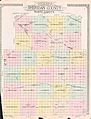
Outline map of Sheridan County, North Dakota, 1914

See also
 In Spanish: Condado de Sheridan (Dakota del Norte) para niños
