
Sherwood, Oregon facts for kids
Quick facts for kids
Sherwood, Oregon
|
|
|---|---|

Building in downtown
|
|
| Nickname(s):
Smockville
|
|
| Motto(s):
Home of the Tualatin River National Wildlife Refuge
|
|

Location in Oregon
|
|
| Country | United States |
| State | Oregon |
| County | Washington |
| Incorporated | 1893 |
| Government | |
| • Type | Council-manager |
| Area | |
| • Total | 4.61 sq mi (11.95 km2) |
| • Land | 4.61 sq mi (11.95 km2) |
| • Water | 0.00 sq mi (0.00 km2) |
| Elevation | 193 ft (59 m) |
| Population
(2010)
|
|
| • Total | 18,194 |
| • Estimate
(2019)
|
19,879 |
| • Density | 4,309.34/sq mi (1,663.72/km2) |
| Time zone | UTC−8 (Pacific) |
| • Summer (DST) | UTC−7 (Pacific) |
| ZIP code |
97140
|
| Area code(s) | 503, 971 |
| FIPS code | 41-67100 |
| GNIS feature ID | 1126877 |
| Website | www.ci.sherwood.or.us |

Sherwood is a city in Washington County, Oregon, United States. Located in the southeast corner of the county, it is a residential community in the Tualatin Valley, southwest of Portland. As of the 2010 census, Sherwood had a population of 18,194 residents. The city's population for 2019 was estimated to be 19,879 by the U.S. Census. Sherwood was first incorporated in 1893 as a town. Originally named Smockville after its founder, James Christopher Smock, the town was given its current name by local businessman Robert Alexander in 1891, who likely named it after his hometown of Sherwood, Michigan.
Contents
History
What is now the Sherwood area was originally inhabited by the Atfalati band of the Kalapuya nation. The first significant wave of United States emigrants arrived in 1842. Native Americans were relocated to reservations after the Donation Land Claim Act of 1850–55 gave American citizens exclusive ownership of these lands. The relocation process took place under the guidance of a series of federal employees, most notably Superintendent of Indian Affairs Joel Palmer, who was severely criticized for his humane treatment of the tribes.
The California Gold Rush of 1849 caused a dramatic shift in the area's economy. of both cities.

The name "Sherwood" arose from a declination of naming the town "Smock Ville" after its co-founders James Christopher and Mary Ellen Smock. In 1885, the Smocks gave a right-of-way on their property to the Portland and Willamette Valley Railway. The Smocks platted the town in 1889, the same year rail service began. Tradition has it that no one, not even the town's founders, liked the name "Smock Ville," and so a public meeting was held to rename the town. Robert Alexander, who was both a local resident and prominent businessman, suggested the name "Sherwood." According to post office records, Alexander was from Sherwood, Michigan, and also said the forest which surrounded the city was like Sherwood Forest in England. The U.S. Postal Department began sending mail to the Town of Sherwood, Oregon on July 5, 1891. Smock was the first postmaster. The Town of Sherwood was incorporated under Oregon Senate Bill 36 in 1893.
The main industry in the 1890s was a pressed brick yard which closed in 1896, a victim of the deep recession of 1893. The Klondike Gold Rush of 1897 revived Sherwood's economy.
The population of the city in 1911 was 350 within a 1-square-mile (2.6 km2) city limit. The city has since expanded to nearly 4.5 square miles (12 km2).
Geography
According to the United States Census Bureau, the city has a total area of 4.31 square miles (11.16 km2), all land.
| Climate data for Sherwood, Oregon | |||||||||||||
|---|---|---|---|---|---|---|---|---|---|---|---|---|---|
| Month | Jan | Feb | Mar | Apr | May | Jun | Jul | Aug | Sep | Oct | Nov | Dec | Year |
| Average high °F (°C) | 49 (9) |
53 (12) |
58 (14) |
63 (17) |
69 (21) |
75 (24) |
81 (27) |
81 (27) |
77 (25) |
65 (18) |
54 (12) |
47 (8) |
64 (18) |
| Average low °F (°C) | 35 (2) |
35 (2) |
38 (3) |
41 (5) |
46 (8) |
50 (10) |
54 (12) |
54 (12) |
50 (10) |
43 (6) |
38 (3) |
34 (1) |
43 (6) |
| Average precipitation inches (mm) | 6.11 (155) |
4.62 (117) |
4.06 (103) |
2.99 (76) |
2.29 (58) |
1.77 (45) |
.56 (14) |
.64 (16) |
1.39 (35) |
3.12 (79) |
6.36 (162) |
6.82 (173) |
40.73 (1,033) |
Demographics
| Historical population | |||
|---|---|---|---|
| Census | Pop. | %± | |
| 1900 | 111 | — | |
| 1910 | 115 | 3.6% | |
| 1920 | 320 | 178.3% | |
| 1930 | 382 | 19.4% | |
| 1940 | 447 | 17.0% | |
| 1950 | 575 | 28.6% | |
| 1960 | 680 | 18.3% | |
| 1970 | 1,396 | 105.3% | |
| 1980 | 2,386 | 70.9% | |
| 1990 | 3,093 | 29.6% | |
| 2000 | 11,791 | 281.2% | |
| 2010 | 18,194 | 54.3% | |
| 2019 (est.) | 19,879 | 9.3% | |
| Sources: | |||

2010 census
As of the census of 2010, there were 18,194 people, 6,316 households, and 4,857 families living in the city. The population density was 4,221.3 inhabitants per square mile (1,629.9/km2). There were 6,569 housing units at an average density of 1,524.1 per square mile (588.5/km2). The racial makeup of the city was 88.5% White, 0.8% African American, 0.5% Native American, 3.5% Asian, 0.3% Pacific Islander, 2.7% from other races, and 3.7% from two or more races. Hispanic or Latino of any race were 7.0% of the population.
There were 6,316 households, of which 49.6% had children under the age of 18 living with them, 63.5% were married couples living together, 9.7% had a female householder with no husband present, 3.6% had a male householder with no wife present, and 23.1% were non-families. 19.0% of all households were made up of individuals, and 6.7% had someone living alone who was 65 years of age or older. The average household size was 2.88 and the average family size was 3.31.
The median age in the city was 34.3 years. 33.6% of residents were under the age of 18; 5% were between the ages of 18 and 24; 32.9% were from 25 to 44; 21.6% were from 45 to 64; and 6.8% were 65 years of age or older. The gender makeup of the city was 48.9% male and 51.1% female.
The median income for a household in the city was $82,579, and the median income for a family was $90,492. Males had a median income of $66,052 versus $47,013 for females. The per capita income for the city was $31,047. About 2.2% of families and 4.1% of the population were below the poverty line, including 3.8% of those under age 18 and 1.0% of those age 65 or over.
Infrastructure and services
Sherwood is within the Tri-County Metropolitan Transportation District of Oregon (TriMet), the Portland metropolitan area's primary transit agency. TriMet bus lines 93, 94 and 97 provide service to Sherwood; line 94 is an express route running through to downtown Portland. Additionally, the Yamhill County Transit Area's routes 44, 45x and 46s connect Sherwood with Newberg, McMinnville, and other points in Yamhill County, which are outside the boundaries of the TriMet district.
Fire protection and emergency medical services are provided through Tualatin Valley Fire and Rescue.
Notable people
- Del Baker, former Major League Baseball player and manager
- Jim Benning, general manager of the Vancouver Canucks
- Dave Edstrom, former Olympic decathlete
- Rich Fellers (born 1959), Olympic equestrian
- A.C. Gibbs, second Governor of Oregon
- Iain Harrison, competitive shooter
- Glenn Olds, politician
- Jiggs Parrott, baseball player
- Thomas H. Parrott, musician
- Tom Parrott, baseball player
- Ilsa Paulson, former professional long-distance runner
- Bud Podbielan, baseball player
- Adley Rutschman, baseball player, #1 pick in the 2019 MLB draft
- Mark Smith, fantasy gamebook author
- Daniela Solís, soccer player
- Chuck Sun, former professional motocross racer
Images for kids
-
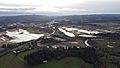
Sherwood from Above - Further down 99W
-

Sherwood's Abandoned Railroad Tracks
-
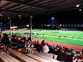
SHS Football Game
-

Gay bike lane in Sherwood, across from the high school.
-
The Sherwood Public Library, in downtown


See also
 In Spanish: Sherwood (Oregón) para niños
