
Siagne facts for kids
Quick facts for kids Siagne |
|
| River | |
 The canyon of the Siagne river
|
|
| Country | France |
|---|---|
| Region | Provence-Alpes-Côte d'Azur |
| Departments | Alpes-Maritimes, Var |
| Tributaries | |
| - left | Vallon de Nans, Moucharonne |
| - right | Siagnole, Biançon |
| Cities | Mandelieu-la-Napoule, Pégomas, La Roquette-sur-Siagne |
| Source | Audibergue mountain |
| - location | Escragnolles, Alpes-Maritimes, Provence-Alpes-Côte d'Azur, France |
| - elevation | 1,367 m (4,485 ft) |
| - coordinates | 43°43′43″N 6°50′15″E / 43.72861°N 6.83750°E |
| Mouth | Mediterranean Sea |
| - location | Mandelieu-la-Napoule, Alpes-Maritimes, Provence-Alpes-Côte d'Azur, France |
| - elevation | 0 m (0 ft) |
| - coordinates | 43°31′51″N 6°56′59″E / 43.53083°N 6.94972°E |
| Length | 44.3 km (28 mi) |
| Basin | 556 km² (215 sq mi) |
| Discharge | for Pégomas |
| - average | 8.75 m³/s (309 cu ft/s) |
The Siagne is a short river that flows through the Var and Alpes-Maritimes departments, in southeastern France.
Geography
The Siagne river has a length of 44.3 km (28 mi) and a drainage basin with an area of approximately 556 km2 (215 sq mi).
Its average yearly discharge (volume of water which passes through a section of the river per unit of time) is 8.75 cubic metres per second at Pégomas, near Cannes.
Course
The Siagne starts on the south side of the Audibergue mountain, in the commune of Escragnolles, Alpes-Maritimes department, at an elevation of about 1,367 m (4,485 ft). It then flows to the southwest through the departments of Alpes-Maritimes and Var. For much of its length, it forms the border between the two departments.
Finally, the river flows into the Mediterranean Sea at the city of Mandelieu-la-Napoule.
The Siagne flows through 2 departments and 13 communes, in one region:
- Alpes-Maritimes department: Escragnolles, Saint-Vallier-de-Thiey, Saint-Cézaire-sur-Siagne, Le Tignet, Peymeinade, Mandelieu-la-Napoule, Auribeau-sur-Siagne, Pégomas, La Roquette-sur-Siagne
- Var: Mons, Callian, Montauroux, Tanneron
Main tributaries
The main tributaries of the Siagne river are:
|
Left tributaries:
|
Right tributaries:
|
Gallery
-
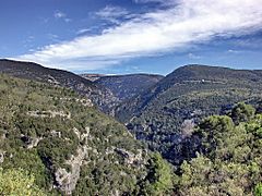
Gorges of the Siagne
-
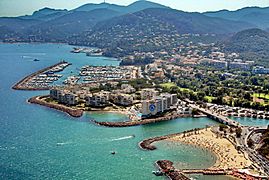
Mouth of the Siagne in Mandelieu-la-Napoule
-
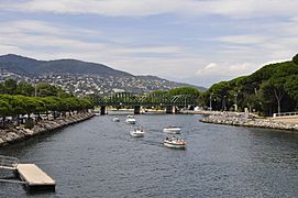
Mouth of the Siagne in Mandelieu-la-Napoule


Related pages
See also
 In Spanish: Río Siagne para niños
